No Photo
Property Record
2800 Liberty Dr, Northampton, PA 18067


NEARBY LISTINGS FOR SALE OR LEASE
Property Detail
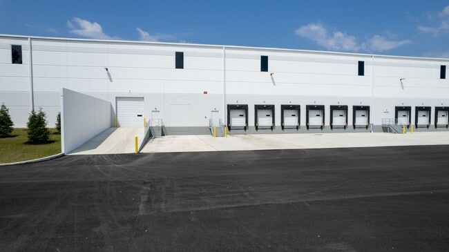
2800 Liberty Dr
L4 9 8-3 0501
Century Commerce Center
Industrialpark
Northampton
X
Pennsylvania
42095C0228E
29.22 AC
2025
Lehigh Valley
2025
Philadelphia
016400
Allentown-Bethlehem-Easton, PA-NJ
316,786 SF
DEMOGRAPHICS near 2800 Liberty Dr
1 Mile
3 Mile
5 Mile
2024 Total Population
945
27,967
72,389
2029 Population
939
28,119
72,818
Pop Growth 2024-2029
(0.63%)
+ 0.54%
+ 0.59%
Average Age
44
43
43
2024 Total Households
369
11,422
28,995
HH Growth 2024-2029
(0.54%)
+ 0.60%
+ 0.60%
Median Household Inc
$97,781
$73,943
$74,728
Avg Household Size
2.50
2.40
2.50
2024 Avg HH Vehicles
2.00
2.00
2.00
Median Home Value
$282,116
$232,004
$245,006
Median Year Built
1976
1968
1970
Nearby Places
Map Layers
Map Styles
 Street
 Aerial
- Restaurants
- Banks
- Shops
- Fitness
- Groceries
PUBLIC TRANSPORTATION
AIRPORT
Lehigh Valley International
DRIVE
WALK
Distance
Lehigh Valley International
11 min
4.5 mi
Freight Ports
Port of Philadelphia
DRIVE
WALK
Distance
Port of Philadelphia
96 min
71.1 mi
SALE & LEASE HISTORY
LISTING DATE
SALE/LEASE

Sep 25, 2016
For Lease
Sep 19, 2019
For Lease
Nearby Properties
Address
Land Use
TOTAL SIZE
Lot Size
Zoning
Address
Land Use
TOTAL SIZE
Lot Size
Zoning
453,600 SF
32.57 AC
PIO
Address
Land Use
TOTAL SIZE
Lot Size
Zoning
1,046,625 SF
69.55 AC
RS
Address
Land Use
TOTAL SIZE
Lot Size
Zoning
956,444 SF
I
Address
Land Use
TOTAL SIZE
Lot Size
Zoning
85.20 AC
I2
Address
Land Use
TOTAL SIZE
Lot Size
Zoning
1,050,392 SF
218.15 AC
RS
Address
Land Use
TOTAL SIZE
Lot Size
Zoning
605,893 SF
I
Address
Land Use
TOTAL SIZE
Lot Size
Zoning
105,219 SF
47.10 AC
RA
Address
Land Use
TOTAL SIZE
Lot Size
Zoning
164,816 SF
48.85 AC
R1
Address
Land Use
TOTAL SIZE
Lot Size
Zoning
292,700 SF
21.68 AC
RS
Address
Land Use
TOTAL SIZE
Lot Size
Zoning
262,476 SF
30.77 AC
I2
Address
Land Use
TOTAL SIZE
Lot Size
Zoning
65,524 SF
22.48 AC
I
Address
Land Use
TOTAL SIZE
Lot Size
Zoning
3,522 SF
20.74 AC
R3
Address
Land Use
TOTAL SIZE
Lot Size
Zoning
11,040 SF
4.18 AC
C-1
Address
Land Use
TOTAL SIZE
Lot Size
Zoning
301,097 SF
14.19 AC
I
Address
Land Use
TOTAL SIZE
Lot Size
Zoning
56,720 SF
4.17 AC
C-1
Address
Land Use
TOTAL SIZE
Lot Size
Zoning
15,750 SF
5.10 AC
R-6
Address
Land Use
TOTAL SIZE
Lot Size
Zoning
9,068 SF
6.10 AC
R-4
Address
Land Use
TOTAL SIZE
Lot Size
Zoning
1,815 SF
29.80 AC
R-6
Address
Land Use
TOTAL SIZE
Lot Size
Zoning
2,339 SF
202.96 AC
OS-2
Address
Land Use
TOTAL SIZE
Lot Size
Zoning
44,041 SF
1.21 AC
R-5A
Address
Land Use
TOTAL SIZE
Lot Size
Zoning
12,376 SF
4.04 AC
R-5A
Address
Land Use
TOTAL SIZE
Lot Size
Zoning
123,343 SF
8.52 AC
I
Address
Land Use
TOTAL SIZE
Lot Size
Zoning
23,887 SF
13.91 AC
AR
Address
Land Use
TOTAL SIZE
Lot Size
Zoning
39,641 SF
7.55 AC
OS-2
Address
Land Use
TOTAL SIZE
Lot Size
Zoning
10,448 SF
3.65 AC
R-6
Address
Land Use
TOTAL SIZE
Lot Size
Zoning
16,226 SF
216.75 AC
RS
Address
Land Use
TOTAL SIZE
Lot Size
Zoning
5,064 SF
3.31 AC
R-3A
Address
Land Use
TOTAL SIZE
Lot Size
Zoning
3,578 SF
5.21 AC
I-1
Address
Land Use
TOTAL SIZE
Lot Size
Zoning
7,601 SF
2.36 AC
R-5A
The World's #1 Commercial Real Estate Marketplace
Connect with us
© 2026 CoStar Group
The information above has been obtained from sources believed reliable. While we do not doubt its accuracy we have not verified it and make no guarantee, warranty or representation about it. It is your responsibility to independently confirm its accuracy and completeness. Any projections, opinions, assumptions, or estimates used are for example only and do not represent the current or future performance of the property. The value of this transaction to you depends on tax and other factors which should be evaluated by your tax, financial, and legal advisors. You and your advisors should conduct a careful, independent investigation of the property to determine to your satisfaction the suitability of the property for your needs.