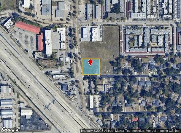
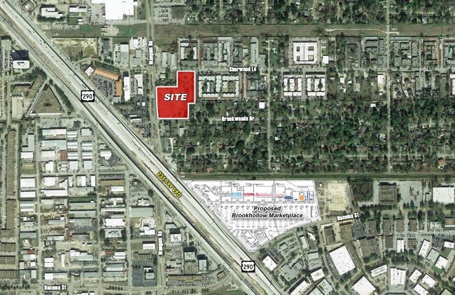
Property Record
2800 Mangum Rd, Houston, TX 77092


Current Lease Availabilities
NEARBY LISTINGS FOR SALE OR LEASE
-
-
-
-
-
-
-
-
-
No Photo
-
-
-
-
-
-
-
-
-
-
-
-
-
-
-
-
-
-
-
-
-
-
View all Houston listings for lease on LoopNet.com
Property Detail
2800 Mangum Rd
Houston-The Woodlands-Sugar Land, TX
Brook-Woods Estates
0760210010001
LTS 1 & 2 BLK 1 BROOK-WOODS ESTATES
Commercialacreage
Harris
X
Texas
48201C0655M
1,2
2024
0.82 AC
2025
Northwest Near
530102
Houston
DEMOGRAPHICS near 2800 Mangum Rd
1 Mile
3 Mile
5 Mile
2024 Total Population
13,257
139,590
403,519
2029 Population
13,830
144,467
418,142
Pop Growth 2024-2029
+ 4.32%
+ 3.49%
+ 3.62%
Average Age
36
37
38
2024 Total Households
5,648
56,628
170,564
HH Growth 2024-2029
+ 4.14%
+ 3.57%
+ 3.77%
Median Household Inc
$40,631
$72,743
$76,432
Avg Household Size
2.30
2.40
2.30
2024 Avg HH Vehicles
2.00
2.00
2.00
Median Home Value
$322,473
$411,824
$420,534
Median Year Built
1976
1978
1984
Nearby Places
- Restaurants
- Banks
- Shops
- Fitness
- Groceries
PUBLIC TRANSPORTATION
COMMUTER RAIL
Houston (Sunset Limited - Amtrak)
DRIVE
WALK
Distance
Houston (Sunset Limited - Amtrak)
14 min
8.4 mi
AIRPORT
William P Hobby
DRIVE
WALK
Distance
William P Hobby
35 min
20.8 mi
George Bush Intcntl/Houston
DRIVE
WALK
Distance
George Bush Intcntl/Houston
28 min
22.4 mi
Freight Ports
Port of Houston
DRIVE
WALK
Distance
Port of Houston
26 min
17.6 mi
Nearby Properties
Address
Land Use
TOTAL SIZE
Lot Size
Zoning
Address
Land Use
TOTAL SIZE
Lot Size
Zoning
563,626 SF
4.71 AC
Address
Land Use
TOTAL SIZE
Lot Size
Zoning
224,114 SF
4.24 AC
Address
Land Use
TOTAL SIZE
Lot Size
Zoning
714,049 SF
25.73 AC
Address
Land Use
TOTAL SIZE
Lot Size
Zoning
324,709 SF
4 AC
Address
Land Use
TOTAL SIZE
Lot Size
Zoning
366,386 SF
10.85 AC
Address
Land Use
TOTAL SIZE
Lot Size
Zoning
375,693 SF
9.16 AC
Address
Land Use
TOTAL SIZE
Lot Size
Zoning
605,420 SF
7.51 AC
Address
Land Use
TOTAL SIZE
Lot Size
Zoning
350,655 SF
16.76 AC
Address
Land Use
TOTAL SIZE
Lot Size
Zoning
279,934 SF
8 AC
Address
Land Use
TOTAL SIZE
Lot Size
Zoning
721,788 SF
10.14 AC
Address
Land Use
TOTAL SIZE
Lot Size
Zoning
379,725 SF
2.84 AC
Address
Land Use
TOTAL SIZE
Lot Size
Zoning
292,292 SF
10.36 AC
Address
Land Use
TOTAL SIZE
Lot Size
Zoning
270,845 SF
10.75 AC
Address
Land Use
TOTAL SIZE
Lot Size
Zoning
443,228 SF
3.15 AC
Address
Land Use
TOTAL SIZE
Lot Size
Zoning
478,524 SF
5.68 AC
Address
Land Use
TOTAL SIZE
Lot Size
Zoning
750,156 SF
22.95 AC
Address
Land Use
TOTAL SIZE
Lot Size
Zoning
322,880 SF
2.61 AC
Address
Land Use
TOTAL SIZE
Lot Size
Zoning
363,503 SF
12.81 AC
Address
Land Use
TOTAL SIZE
Lot Size
Zoning
402,433 SF
2.77 AC
Address
Land Use
TOTAL SIZE
Lot Size
Zoning
378,225 SF
11.51 AC
Address
Land Use
TOTAL SIZE
Lot Size
Zoning
280,241 SF
1.90 AC
Address
Land Use
TOTAL SIZE
Lot Size
Zoning
418,456 SF
5.72 AC
Address
Land Use
TOTAL SIZE
Lot Size
Zoning
394,910 SF
15.04 AC
Address
Land Use
TOTAL SIZE
Lot Size
Zoning
185,068 SF
21.92 AC
Address
Land Use
TOTAL SIZE
Lot Size
Zoning
229,369 SF
4 AC
Address
Land Use
TOTAL SIZE
Lot Size
Zoning
304,557 SF
4.90 AC
Address
Land Use
TOTAL SIZE
Lot Size
Zoning
198,259 SF
19.57 AC
Address
Land Use
TOTAL SIZE
Lot Size
Zoning
228,804 SF
3.28 AC
Address
Land Use
TOTAL SIZE
Lot Size
Zoning
265,830 SF
14.53 AC
Address
Land Use
TOTAL SIZE
Lot Size
Zoning
259,716 SF
6.31 AC
The World's #1 Commercial Real Estate Marketplace
Connect with us
© 2025 CoStar Group
The information above has been obtained from sources believed reliable. While we do not doubt its accuracy we have not verified it and make no guarantee, warranty or representation about it. It is your responsibility to independently confirm its accuracy and completeness. Any projections, opinions, assumptions, or estimates used are for example only and do not represent the current or future performance of the property. The value of this transaction to you depends on tax and other factors which should be evaluated by your tax, financial, and legal advisors. You and your advisors should conduct a careful, independent investigation of the property to determine to your satisfaction the suitability of the property for your needs.