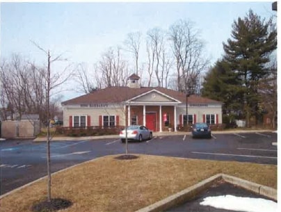
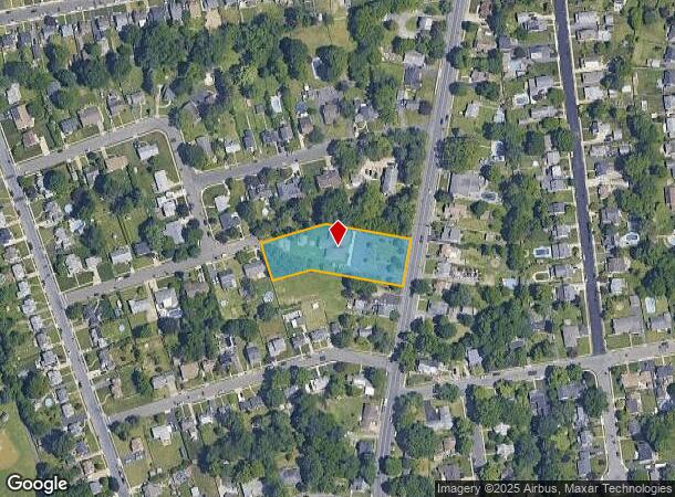
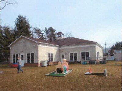
Property Record
2800 Mer-Quaker Branch Rd, Hamilton, NJ 08619
NEARBY LISTINGS FOR SALE OR LEASE
Property Detail
2800 Mer-Quaker Branch Rd
03-01692-0000-00007
01117-
Publicschool
Mercer
X
New Jersey
34021C0227F
7
2024
1.04 AC
2025
Trenton
002902
Northern New Jersey
4,424 SF
Trenton, NJ
DEMOGRAPHICS near 2800 Mer-Quaker Branch Rd
1 Mile
3 Mile
5 Mile
2024 Total Population
10,159
82,448
230,069
2029 Population
9,945
80,963
226,801
Pop Growth 2024-2029
(2.11%)
(1.80%)
(1.42%)
Average Age
45
42
40
2024 Total Households
3,951
31,511
84,642
HH Growth 2024-2029
(2.20%)
(1.88%)
(1.50%)
Median Household Inc
$100,482
$91,249
$77,336
Avg Household Size
2.50
2.50
2.60
2024 Avg HH Vehicles
2.00
2.00
2.00
Median Home Value
$277,766
$278,227
$264,913
Median Year Built
1958
1965
1960
Nearby Places
Map Layers
Map Styles
 Street
 Aerial
- Restaurants
- Banks
- Shops
- Fitness
- Groceries
PUBLIC TRANSPORTATION
COMMUTER RAIL
Hamilton (Northeast Corridor Line - NJ Transit Commuter Rail (NJ Transit))
DRIVE
WALK
Distance
Hamilton (Northeast Corridor Line - NJ Transit Commuter Rail (NJ Transit))
5 min
1.9 mi
Trenton Transit Center (Njt) (Northeast Corridor Line - NJ Transit Commuter Rail (NJ Transit), R7 - NJ Transit Commuter Rail (NJ Transit), River LINE - NJ Transit Commuter Rail (NJ Transit))
DRIVE
WALK
Distance
Trenton Transit Center (Njt) (Northeast Corridor Line - NJ Transit Commuter Rail (NJ Transit), R7 - NJ Transit Commuter Rail (NJ Transit), River LINE - NJ Transit Commuter Rail (NJ Transit))
10 min
4.4 mi
AIRPORT
Trenton Mercer
DRIVE
WALK
Distance
Trenton Mercer
19 min
13.1 mi
Freight Ports
Port of Philadelphia
DRIVE
WALK
Distance
Port of Philadelphia
48 min
37.5 mi
Nearby Properties
Address
Land Use
TOTAL SIZE
Lot Size
Zoning
Address
Land Use
TOTAL SIZE
Lot Size
Zoning
40.83 AC
E
Address
Land Use
TOTAL SIZE
Lot Size
Zoning
70.44 AC
MX-1
Address
Land Use
TOTAL SIZE
Lot Size
Zoning
Address
Land Use
TOTAL SIZE
Lot Size
Zoning
56.45 AC
EGI
Address
Land Use
TOTAL SIZE
Lot Size
Zoning
18.33 AC
Address
Land Use
TOTAL SIZE
Lot Size
Zoning
17.84 AC
HC
Address
Land Use
TOTAL SIZE
Lot Size
Zoning
Address
Land Use
TOTAL SIZE
Lot Size
Zoning
44.83 AC
I
Address
Land Use
TOTAL SIZE
Lot Size
Zoning
21.17 AC
I
Address
Land Use
TOTAL SIZE
Lot Size
Zoning
9.63 AC
RD
Address
Land Use
TOTAL SIZE
Lot Size
Zoning
27.50 AC
R7
Address
Land Use
TOTAL SIZE
Lot Size
Zoning
Address
Land Use
TOTAL SIZE
Lot Size
Zoning
47.84 AC
HC
Address
Land Use
TOTAL SIZE
Lot Size
Zoning
Address
Land Use
TOTAL SIZE
Lot Size
Zoning
15.80 AC
C
Address
Land Use
TOTAL SIZE
Lot Size
Zoning
28.36 AC
E
Address
Land Use
TOTAL SIZE
Lot Size
Zoning
Address
Land Use
TOTAL SIZE
Lot Size
Zoning
156,128 SF
6.33 AC
RB
Address
Land Use
TOTAL SIZE
Lot Size
Zoning
Address
Land Use
TOTAL SIZE
Lot Size
Zoning
Address
Land Use
TOTAL SIZE
Lot Size
Zoning
Address
Land Use
TOTAL SIZE
Lot Size
Zoning
17,500 SF
18.14 AC
HC
Address
Land Use
TOTAL SIZE
Lot Size
Zoning
9.31 AC
HC
Address
Land Use
TOTAL SIZE
Lot Size
Zoning
16.62 AC
Address
Land Use
TOTAL SIZE
Lot Size
Zoning
14,574 SF
20.23 AC
R10
Address
Land Use
TOTAL SIZE
Lot Size
Zoning
Address
Land Use
TOTAL SIZE
Lot Size
Zoning
12.17 AC
AT
Address
Land Use
TOTAL SIZE
Lot Size
Zoning
21.91 AC
R10
Address
Land Use
TOTAL SIZE
Lot Size
Zoning
16,199 SF
11.80 AC
REO4
Address
Land Use
TOTAL SIZE
Lot Size
Zoning
22.39 AC
I
The World's #1 Commercial Real Estate Marketplace
Connect with us
© 2025 CoStar Group
The information above has been obtained from sources believed reliable. While we do not doubt its accuracy we have not verified it and make no guarantee, warranty or representation about it. It is your responsibility to independently confirm its accuracy and completeness. Any projections, opinions, assumptions, or estimates used are for example only and do not represent the current or future performance of the property. The value of this transaction to you depends on tax and other factors which should be evaluated by your tax, financial, and legal advisors. You and your advisors should conduct a careful, independent investigation of the property to determine to your satisfaction the suitability of the property for your needs.