No Photo
Property Record
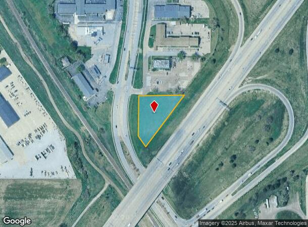
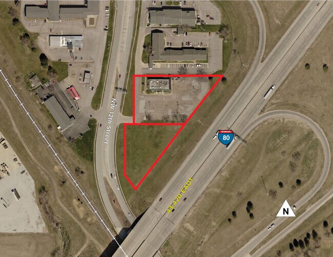
2800 N 12Th St, Lincoln, NE 68521

NEARBY LISTINGS FOR SALE OR LEASE
Property Detail
2800 N 12Th St
Lincoln, NE
6Th Principal Meridian
11-15-100-001-000
S15, T10, R6, 6TH PRINCIPAL MERIDIAN, IRREGULAR TRACT LOT 55 NW
Commercialacreage
Lancaster
X
Nebraska
31109C0305F
55
2024
1.05 AC
2025
North Central
003002
Lincoln
DEMOGRAPHICS near 2800 N 12Th St
1 Mile
3 Mile
5 Mile
2024 Total Population
4,869
60,297
148,855
2029 Population
5,025
62,542
154,441
Pop Growth 2024-2029
+ 3.20%
+ 3.72%
+ 3.75%
Average Age
34
33
35
2024 Total Households
1,697
21,759
59,121
HH Growth 2024-2029
+ 3.24%
+ 4.12%
+ 4.05%
Median Household Inc
$42,979
$51,787
$49,933
Avg Household Size
2.80
2.40
2.30
2024 Avg HH Vehicles
2.00
2.00
2.00
Median Home Value
$168,898
$192,461
$186,259
Median Year Built
1990
1991
1976
Nearby Places
Map Layers
Map Styles
 Street
 Aerial
- Restaurants
- Banks
- Shops
- Fitness
- Groceries
PUBLIC TRANSPORTATION
COMMUTER RAIL
DRIVE
WALK
Distance
6 min
3.3 mi
AIRPORT
Lincoln
DRIVE
WALK
Distance
Lincoln
3 min
1.3 mi
SALE & LEASE HISTORY
LISTING DATE
SALE/LEASE

Aug 02, 2021
For Lease
Nearby Properties
Address
Land Use
TOTAL SIZE
Lot Size
Zoning
Address
Land Use
TOTAL SIZE
Lot Size
Zoning
30,018 SF
100.37 AC
R3
Address
Land Use
TOTAL SIZE
Lot Size
Zoning
134,835 SF
1.22 AC
B4
Address
Land Use
TOTAL SIZE
Lot Size
Zoning
131,328 SF
2.07 AC
P
Address
Land Use
TOTAL SIZE
Lot Size
Zoning
301,402 SF
35.38 AC
H3
Address
Land Use
TOTAL SIZE
Lot Size
Zoning
65,430 SF
1.12 AC
B4
Address
Land Use
TOTAL SIZE
Lot Size
Zoning
182,668 SF
2.07 AC
B4
Address
Land Use
TOTAL SIZE
Lot Size
Zoning
35,233 SF
28.52 AC
NULL
Address
Land Use
TOTAL SIZE
Lot Size
Zoning
72,047 SF
1.03 AC
B4
Address
Land Use
TOTAL SIZE
Lot Size
Zoning
216,894 SF
1.47 AC
B4
Address
Land Use
TOTAL SIZE
Lot Size
Zoning
708,074 SF
66.04 AC
I1
Address
Land Use
TOTAL SIZE
Lot Size
Zoning
217,115 SF
2.03 AC
B4
Address
Land Use
TOTAL SIZE
Lot Size
Zoning
190,000 SF
158.97 AC
I1
Address
Land Use
TOTAL SIZE
Lot Size
Zoning
189,854 SF
2.07 AC
P
Address
Land Use
TOTAL SIZE
Lot Size
Zoning
287,193 SF
6.62 AC
B4
Address
Land Use
TOTAL SIZE
Lot Size
Zoning
92,418 SF
0.79 AC
B4
Address
Land Use
TOTAL SIZE
Lot Size
Zoning
180,578 SF
1.32 AC
P
Address
Land Use
TOTAL SIZE
Lot Size
Zoning
56,867 SF
22.10 AC
NULL
Address
Land Use
TOTAL SIZE
Lot Size
Zoning
32,110 SF
9.64 AC
B2
Address
Land Use
TOTAL SIZE
Lot Size
Zoning
22,552 SF
16.68 AC
NULL
Address
Land Use
TOTAL SIZE
Lot Size
Zoning
27,398 SF
7.78 AC
R3
Address
Land Use
TOTAL SIZE
Lot Size
Zoning
523.53 AC
I1
Address
Land Use
TOTAL SIZE
Lot Size
Zoning
141,120 SF
21 AC
O3
Address
Land Use
TOTAL SIZE
Lot Size
Zoning
119,655 SF
2.28 AC
B4
Address
Land Use
TOTAL SIZE
Lot Size
Zoning
63,003 SF
1.22 AC
O3
Address
Land Use
TOTAL SIZE
Lot Size
Zoning
228,960 SF
11.04 AC
I2
Address
Land Use
TOTAL SIZE
Lot Size
Zoning
47,017 SF
0.92 AC
B4
Address
Land Use
TOTAL SIZE
Lot Size
Zoning
23,881 SF
0.80 AC
B4
Address
Land Use
TOTAL SIZE
Lot Size
Zoning
121,860 SF
6.51 AC
P
Address
Land Use
TOTAL SIZE
Lot Size
Zoning
317,607 SF
20.81 AC
I2
The World's #1 Commercial Real Estate Marketplace
Connect with us
© 2026 CoStar Group
The information above has been obtained from sources believed reliable. While we do not doubt its accuracy we have not verified it and make no guarantee, warranty or representation about it. It is your responsibility to independently confirm its accuracy and completeness. Any projections, opinions, assumptions, or estimates used are for example only and do not represent the current or future performance of the property. The value of this transaction to you depends on tax and other factors which should be evaluated by your tax, financial, and legal advisors. You and your advisors should conduct a careful, independent investigation of the property to determine to your satisfaction the suitability of the property for your needs.