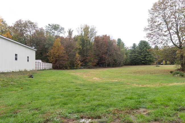
Property Record
2800 State Route 49, West Monroe, NY 13167
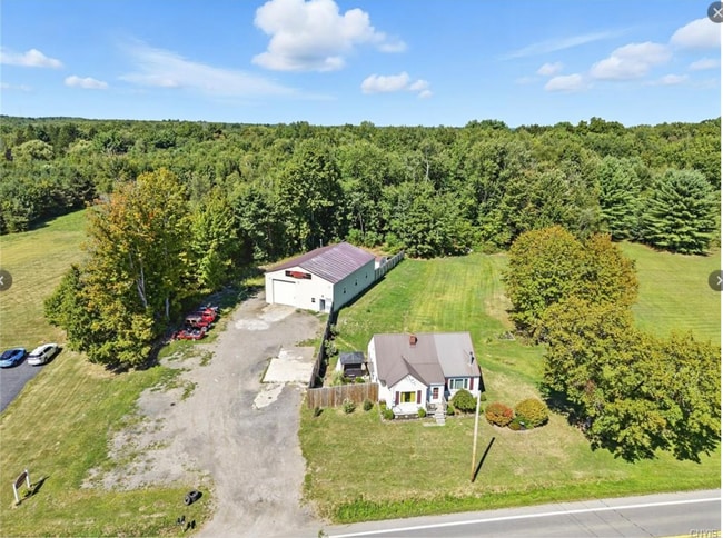

This Property Is For Sale
Current Lease Availabilities
Property Detail
2800 State Route 49
356000-277-000-0001-009-000-0000
LOT 98 005-023-000
Autorepair
Oswego
CI
New York
B and X Area of moderate flood hazard, usually the area between the limits of the 100-year and 500-year floods.
9.000
2025
5 AC
2025
Oswego County
020704
Syracuse
1,446 SF
Syracuse, NY
NEARBY LISTINGS FOR SALE OR LEASE
DEMOGRAPHICS near 2800 State Route 49
1 mile
3 mile
5 mile
2025 Total Population
372
5,959
16,773
2030 Population
370
5,948
16,734
Pop Growth 2025-2030
(0.54%)
(0.18%)
(0.23%)
Average Age
44
43
43
2025 Total Households
154
2,506
6,857
HH Growth 2025-2030
(0.65%)
0.00%
(0.22%)
Median Household Inc
$96,153
$83,754
$91,566
Avg Household Size
2.30
2.30
2.40
2025 Avg HH Vehicles
2.00
2.00
2.00
Median Home Value
$207,143
$200,832
$209,960
Median Year Built
1977
1980
1983
Nearby Places
Map Layers
Map Styles
 Street
 Aerial
Layers
 Traffic
 Biking
Places
Listings with unknown addresses are not visible on the map
- Restaurants
- Banks
- Shops
- Fitness
- Groceries
PUBLIC TRANSPORTATION
AIRPORT
Syracuse Hancock International
Drive
Walk
Distance
Syracuse Hancock International
21 min
15.1 mi
Freight Ports
Albany, NY Port
Drive
Walk
Distance
Albany, NY Port
185 min
147.9 mi
Nearby Properties
Address
Land Use
TOTAL SIZE
Lot Size
Zoning
Address
Land Use
TOTAL SIZE
Lot Size
Zoning
97,288 SF
62.96 AC
05
Address
Land Use
TOTAL SIZE
Lot Size
Zoning
150,670 SF
31.81 AC
CR
Address
Land Use
TOTAL SIZE
Lot Size
Zoning
145,896 SF
58.25 AC
02 - SINGL
Address
Land Use
TOTAL SIZE
Lot Size
Zoning
924 SF
51.62 AC
CR
Address
Land Use
TOTAL SIZE
Lot Size
Zoning
50,512 SF
4.50 AC
05 - COMME
Address
Land Use
TOTAL SIZE
Lot Size
Zoning
32,640 SF
4.48 AC
Address
Land Use
TOTAL SIZE
Lot Size
Zoning
1,344 SF
61.57 AC
RUR
Address
Land Use
TOTAL SIZE
Lot Size
Zoning
23,168 SF
3.19 AC
05 - COMME
Address
Land Use
TOTAL SIZE
Lot Size
Zoning
4,416 SF
5.37 AC
03 - MULTI
Address
Land Use
TOTAL SIZE
Lot Size
Zoning
1,900 SF
144.90 AC
01 - NOT Z
Address
Land Use
TOTAL SIZE
Lot Size
Zoning
6,000 SF
10.07 AC
CI
Address
Land Use
TOTAL SIZE
Lot Size
Zoning
10,162 SF
21.86 AC
02 - SINGL
Address
Land Use
TOTAL SIZE
Lot Size
Zoning
22,113 SF
5.20 AC
02 - SINGL
Address
Land Use
TOTAL SIZE
Lot Size
Zoning
25,420 SF
3.42 AC
02 - SINGL
Address
Land Use
TOTAL SIZE
Lot Size
Zoning
3,200 SF
6.39 AC
CI
Address
Land Use
TOTAL SIZE
Lot Size
Zoning
19,028 SF
5.55 AC
Address
Land Use
TOTAL SIZE
Lot Size
Zoning
1,360 SF
28.10 AC
Address
Land Use
TOTAL SIZE
Lot Size
Zoning
10,640 SF
1.56 AC
02 - SINGL
Address
Land Use
TOTAL SIZE
Lot Size
Zoning
14,034 SF
11.96 AC
Address
Land Use
TOTAL SIZE
Lot Size
Zoning
10,856 SF
2.94 AC
03 - MULTI
Address
Land Use
TOTAL SIZE
Lot Size
Zoning
6,600 SF
282.70 AC
RES
Address
Land Use
TOTAL SIZE
Lot Size
Zoning
7.57 AC
R1
Address
Land Use
TOTAL SIZE
Lot Size
Zoning
3,600 SF
0.92 AC
Address
Land Use
TOTAL SIZE
Lot Size
Zoning
16,332 SF
2.44 AC
Address
Land Use
TOTAL SIZE
Lot Size
Zoning
4,232 SF
1.77 AC
Address
Land Use
TOTAL SIZE
Lot Size
Zoning
1.43 AC
01 - NOT Z
Address
Land Use
TOTAL SIZE
Lot Size
Zoning
4,140 SF
41.19 AC
WH
Address
Land Use
TOTAL SIZE
Lot Size
Zoning
7,995 SF
28.10 AC
Address
Land Use
TOTAL SIZE
Lot Size
Zoning
9,948 SF
5.86 AC
CR
Address
Land Use
TOTAL SIZE
Lot Size
Zoning
The World's #1 Commercial Real Estate Marketplace
Connect with us
© 2026 CoStar Group
The information above has been obtained from sources believed reliable. While we do not doubt its accuracy we have not verified it and make no guarantee, warranty or representation about it. It is your responsibility to independently confirm its accuracy and completeness. Any projections, opinions, assumptions, or estimates used are for example only and do not represent the current or future performance of the property. The value of this transaction to you depends on tax and other factors which should be evaluated by your tax, financial, and legal advisors. You and your advisors should conduct a careful, independent investigation of the property to determine to your satisfaction the suitability of the property for your needs.