Property Record
2800 Palisades Dr, Corona, CA 92878


Save to a Folder
{{folder.Name}}
{{folder.ListingIds.length}} Properties
{{folder.ListingIds.length}} Property
Create a New Folder
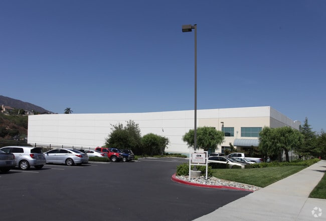
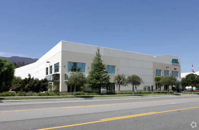
Property Detail
2800 Palisades Dr
Riverside-San Bernardino-Ontario, CA
3.43 ACRES IN PAR 8 PM 196/019 PM 28932
102-820-008
Riverside
Lightindustrial
California
AE The base floodplain where base flood elevations are provided. AE Zones are now used on new format FIRMs instead of A1-A30 Zones.
8
2024
3.43 AC
2025
Corona/Eastvale
041912
Inland Empire (California)
30,317 SF
NEARBY LISTINGS FOR SALE OR LEASE
DEMOGRAPHICS near 2800 Palisades Dr
1 mile
3 mile
5 mile
2025 Total Population
8,724
60,089
150,360
2030 Population
8,858
61,055
152,554
Pop Growth 2025-2030
+ 1.54%
+ 1.61%
+ 1.46%
Average Age
39
37
38
2025 Total Households
2,878
17,878
43,111
HH Growth 2025-2030
+ 0.94%
+ 1.09%
+ 0.95%
Median Household Inc
$115,519
$102,899
$111,738
Avg Household Size
3.00
3.20
3.30
2025 Avg HH Vehicles
2.00
2.00
2.00
Median Home Value
$743,605
$715,471
$741,649
Median Year Built
1987
1983
1986
Nearby Places
Map Layers
Map Styles
 Street
 Aerial
Layers
 Traffic
 Biking
Places
Listings with unknown addresses are not visible on the map
- Restaurants
- Banks
- Shops
- Fitness
- Groceries
PUBLIC TRANSPORTATION
COMMUTER RAIL
West Corona (91 Line - Southern California Regional Rail Authority (Metrolink), Inland Empire-Orange County Line - Southern California Regional Rail Authority (Metrolink))
Drive
Walk
Distance
West Corona (91 Line - Southern California Regional Rail Authority (Metrolink), Inland Empire-Orange County Line - Southern California Regional Rail Authority (Metrolink))
5 min
1.5 mi
North Main Corona (91 Line - Southern California Regional Rail Authority (Metrolink), Inland Empire-Orange County Line - Southern California Regional Rail Authority (Metrolink))
Drive
Walk
Distance
North Main Corona (91 Line - Southern California Regional Rail Authority (Metrolink), Inland Empire-Orange County Line - Southern California Regional Rail Authority (Metrolink))
8 min
4.3 mi
AIRPORT
Ontario International
Drive
Walk
Distance
Ontario International
29 min
19.6 mi
John Wayne/Orange County
Drive
Walk
Distance
John Wayne/Orange County
33 min
24.9 mi
Long Beach (Daugherty Field)
Drive
Walk
Distance
Long Beach (Daugherty Field)
49 min
39.4 mi
Nearby Properties
Address
Land Use
TOTAL SIZE
Lot Size
Zoning
Address
Land Use
TOTAL SIZE
Lot Size
Zoning
91,619 SF
12.54 AC
HDR
Address
Land Use
TOTAL SIZE
Lot Size
Zoning
29,695 SF
18.71 AC
R3
Address
Land Use
TOTAL SIZE
Lot Size
Zoning
263,872 SF
12.87 AC
Address
Land Use
TOTAL SIZE
Lot Size
Zoning
245,658 SF
15.38 AC
PD
Address
Land Use
TOTAL SIZE
Lot Size
Zoning
182,066 SF
9.31 AC
Address
Land Use
TOTAL SIZE
Lot Size
Zoning
357,900 SF
18.93 AC
Address
Land Use
TOTAL SIZE
Lot Size
Zoning
311,297 SF
13.39 AC
Address
Land Use
TOTAL SIZE
Lot Size
Zoning
482,479 SF
26.14 AC
M2
Address
Land Use
TOTAL SIZE
Lot Size
Zoning
63,130 SF
10.20 AC
R3
Address
Land Use
TOTAL SIZE
Lot Size
Zoning
203,476 SF
10.40 AC
C3
Address
Land Use
TOTAL SIZE
Lot Size
Zoning
110,334 SF
11 AC
NCD
Address
Land Use
TOTAL SIZE
Lot Size
Zoning
95,028 SF
5.44 AC
Address
Land Use
TOTAL SIZE
Lot Size
Zoning
321,700 SF
15.01 AC
M2
Address
Land Use
TOTAL SIZE
Lot Size
Zoning
185,736 SF
9.90 AC
Address
Land Use
TOTAL SIZE
Lot Size
Zoning
98,000 SF
5.17 AC
Address
Land Use
TOTAL SIZE
Lot Size
Zoning
724,238 SF
34.31 AC
Address
Land Use
TOTAL SIZE
Lot Size
Zoning
150,375 SF
7.11 AC
Address
Land Use
TOTAL SIZE
Lot Size
Zoning
188,875 SF
9.37 AC
Address
Land Use
TOTAL SIZE
Lot Size
Zoning
229,318 SF
10.63 AC
RR
Address
Land Use
TOTAL SIZE
Lot Size
Zoning
242,670 SF
7.71 AC
Address
Land Use
TOTAL SIZE
Lot Size
Zoning
146,339 SF
7.43 AC
RR
Address
Land Use
TOTAL SIZE
Lot Size
Zoning
68,913 SF
3.72 AC
Address
Land Use
TOTAL SIZE
Lot Size
Zoning
57,200 SF
3.48 AC
Address
Land Use
TOTAL SIZE
Lot Size
Zoning
48,560 SF
9.74 AC
Address
Land Use
TOTAL SIZE
Lot Size
Zoning
139,078 SF
1.67 AC
M1
Address
Land Use
TOTAL SIZE
Lot Size
Zoning
113,740 SF
5.82 AC
Address
Land Use
TOTAL SIZE
Lot Size
Zoning
173,427 SF
7.73 AC
M2
Address
Land Use
TOTAL SIZE
Lot Size
Zoning
135,449 SF
5.35 AC
M1
The World's #1 Commercial Real Estate Marketplace
Connect with us
© 2026 CoStar Group
The information above has been obtained from sources believed reliable. While we do not doubt its accuracy we have not verified it and make no guarantee, warranty or representation about it. It is your responsibility to independently confirm its accuracy and completeness. Any projections, opinions, assumptions, or estimates used are for example only and do not represent the current or future performance of the property. The value of this transaction to you depends on tax and other factors which should be evaluated by your tax, financial, and legal advisors. You and your advisors should conduct a careful, independent investigation of the property to determine to your satisfaction the suitability of the property for your needs.