Property Record
2800 Renfro Rd, Bakersfield, CA 93314

Property Detail
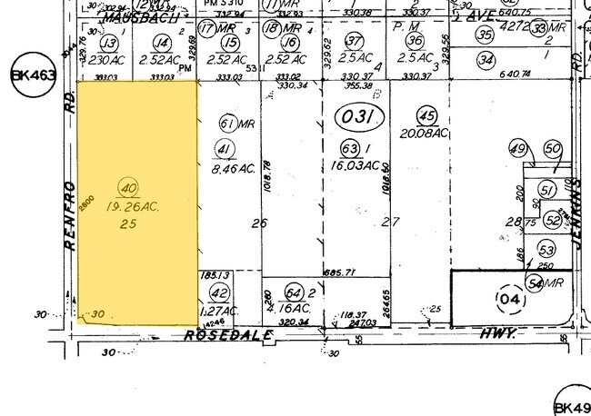
2800 Renfro Rd
464-031-40-00-4
SECTION 23 , TOWNSHIP 29 , RANGE 26 , QUARTER
Industrialacreage
KERN
M-1
California
B and X Area of moderate flood hazard, usually the area between the limits of the 100-year and 500-year floods.
19.26 AC
2024
Northwest Bakersfield
2025
Bakersfield
003824
Bakersfield-Delano, CA
14,556 SF
NEARBY LISTINGS FOR SALE OR LEASE
DEMOGRAPHICS near 2800 Renfro Rd
1 mile
3 mile
5 mile
2025 Total Population
8,471
62,128
124,361
2030 Population
8,505
62,838
126,773
Pop Growth 2025-2030
+ 0.40%
+ 1.14%
+ 1.94%
Average Age
39
37
38
2025 Total Households
2,766
19,797
41,408
HH Growth 2025-2030
+ 0.18%
+ 1.00%
+ 1.88%
Median Household Inc
$114,400
$122,842
$119,513
Avg Household Size
3.00
3.10
2.90
2025 Avg HH Vehicles
2.00
2.00
2.00
Median Home Value
$622,900
$472,162
$462,995
Median Year Built
2001
2001
2000
Nearby Places
Map Layers
Map Styles
 Street
 Aerial
Layers
 Traffic
 Biking
Places
Listings with unknown addresses are not visible on the map
- Restaurants
- Banks
- Shops
- Fitness
- Groceries
PUBLIC TRANSPORTATION
COMMUTER RAIL
Bakersfield (San Joaquins - Amtrak)
Drive
Walk
Distance
Bakersfield (San Joaquins - Amtrak)
18 min
9.7 mi
AIRPORT
Meadows Field
Drive
Walk
Distance
Meadows Field
22 min
11.5 mi
Freight Ports
The Port of Hueneme
Drive
Walk
Distance
The Port of Hueneme
164 min
129.2 mi
Nearby Properties
Address
Land Use
TOTAL SIZE
Lot Size
Zoning
Address
Land Use
TOTAL SIZE
Lot Size
Zoning
319,531 SF
17.66 AC
R3
Address
Land Use
TOTAL SIZE
Lot Size
Zoning
7,008 SF
46 AC
R1
Address
Land Use
TOTAL SIZE
Lot Size
Zoning
51,517 SF
8.11 AC
CO
Address
Land Use
TOTAL SIZE
Lot Size
Zoning
86,729 SF
8.59 AC
C2
Address
Land Use
TOTAL SIZE
Lot Size
Zoning
1,860 SF
7.86 AC
Address
Land Use
TOTAL SIZE
Lot Size
Zoning
237,350 SF
25.31 AC
C2
Address
Land Use
TOTAL SIZE
Lot Size
Zoning
17,376 SF
25.71 AC
R1
Address
Land Use
TOTAL SIZE
Lot Size
Zoning
5,450 SF
4.54 AC
R-2
Address
Land Use
TOTAL SIZE
Lot Size
Zoning
41,217 SF
4.33 AC
C-2 PCD
Address
Land Use
TOTAL SIZE
Lot Size
Zoning
9.16 AC
Address
Land Use
TOTAL SIZE
Lot Size
Zoning
11,127 SF
2.62 AC
R-2
Address
Land Use
TOTAL SIZE
Lot Size
Zoning
50,547 SF
5.17 AC
C2 PD
Address
Land Use
TOTAL SIZE
Lot Size
Zoning
Address
Land Use
TOTAL SIZE
Lot Size
Zoning
9,535 SF
2.58 AC
C2
Address
Land Use
TOTAL SIZE
Lot Size
Zoning
8,361 SF
3.42 AC
C2
Address
Land Use
TOTAL SIZE
Lot Size
Zoning
Address
Land Use
TOTAL SIZE
Lot Size
Zoning
22,290 SF
23.55 AC
E
Address
Land Use
TOTAL SIZE
Lot Size
Zoning
18,954 SF
2.23 AC
R-2
Address
Land Use
TOTAL SIZE
Lot Size
Zoning
47,190 SF
3.61 AC
C2
Address
Land Use
TOTAL SIZE
Lot Size
Zoning
18,954 SF
2.57 AC
R-2
Address
Land Use
TOTAL SIZE
Lot Size
Zoning
3,110 SF
17 AC
M1
Address
Land Use
TOTAL SIZE
Lot Size
Zoning
Address
Land Use
TOTAL SIZE
Lot Size
Zoning
11,127 SF
1.85 AC
R-2
Address
Land Use
TOTAL SIZE
Lot Size
Zoning
6,426 SF
4.09 AC
Address
Land Use
TOTAL SIZE
Lot Size
Zoning
1.16 AC
C-2 PD
Address
Land Use
TOTAL SIZE
Lot Size
Zoning
15,052 SF
1.28 AC
C-2
Address
Land Use
TOTAL SIZE
Lot Size
Zoning
16,704 SF
2.12 AC
R-S
Address
Land Use
TOTAL SIZE
Lot Size
Zoning
0.95 AC
C-2 PD
Address
Land Use
TOTAL SIZE
Lot Size
Zoning
9,600 SF
8.76 AC
M3
Address
Land Use
TOTAL SIZE
Lot Size
Zoning
4.98 AC
R1
The World's #1 Commercial Real Estate Marketplace
Connect with us
© 2026 CoStar Group
The information above has been obtained from sources believed reliable. While we do not doubt its accuracy we have not verified it and make no guarantee, warranty or representation about it. It is your responsibility to independently confirm its accuracy and completeness. Any projections, opinions, assumptions, or estimates used are for example only and do not represent the current or future performance of the property. The value of this transaction to you depends on tax and other factors which should be evaluated by your tax, financial, and legal advisors. You and your advisors should conduct a careful, independent investigation of the property to determine to your satisfaction the suitability of the property for your needs.