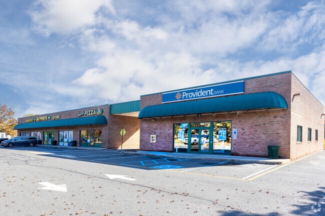
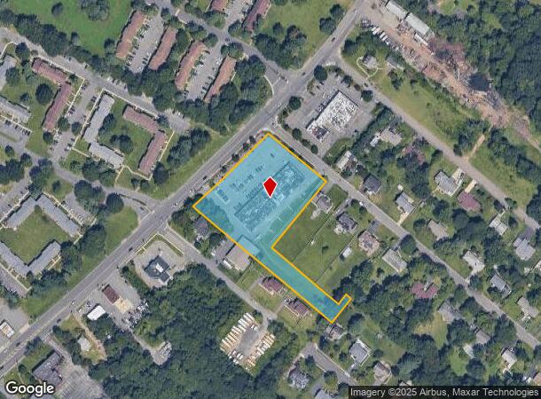
Property Record
2800 Route 27, North Brunswick, NJ 08902

Current Lease Availabilities
NEARBY LISTINGS FOR SALE OR LEASE
Property Detail
2800 Route 27
14-00002-0000-00002-05
2.93 AC
Regionalshoppingcenterormallwithanchorstore
Middlesex
X
New Jersey
34023C0109F
2.5
2024
2.93 AC
2025
Brunswick
006204
Northern New Jersey
19,350 SF
New York-Jersey City-White Plains, NY-NJ
DEMOGRAPHICS near 2800 Route 27
1 Mile
3 Mile
5 Mile
2024 Total Population
11,955
62,656
161,376
2029 Population
11,948
62,495
160,508
Pop Growth 2024-2029
(0.06%)
(0.26%)
(0.54%)
Average Age
39
39
39
2024 Total Households
4,485
22,380
54,923
HH Growth 2024-2029
(0.13%)
(0.33%)
(0.52%)
Median Household Inc
$105,520
$111,180
$110,416
Avg Household Size
2.60
2.70
2.80
2024 Avg HH Vehicles
2.00
2.00
2.00
Median Home Value
$419,394
$424,470
$422,539
Median Year Built
1983
1985
1982
Nearby Places
Map Layers
Map Styles
 Street
 Aerial
- Restaurants
- Banks
- Shops
- Fitness
- Groceries
PUBLIC TRANSPORTATION
COMMUTER RAIL
Jersey Avenue (Northeast Corridor Line - NJ Transit Commuter Rail (NJ Transit))
DRIVE
WALK
Distance
Jersey Avenue (Northeast Corridor Line - NJ Transit Commuter Rail (NJ Transit))
11 min
4.5 mi
New Brunswick (Northeast Corridor Line - NJ Transit Commuter Rail (NJ Transit))
DRIVE
WALK
Distance
New Brunswick (Northeast Corridor Line - NJ Transit Commuter Rail (NJ Transit))
16 min
6.0 mi
AIRPORT
Newark Liberty International
DRIVE
WALK
Distance
Newark Liberty International
44 min
33.7 mi
Nearby Properties
Address
Land Use
TOTAL SIZE
Lot Size
Zoning
Address
Land Use
TOTAL SIZE
Lot Size
Zoning
99.79 AC
B-I
Address
Land Use
TOTAL SIZE
Lot Size
Zoning
31.07 AC
ERR
Address
Land Use
TOTAL SIZE
Lot Size
Zoning
543,945 SF
48.46 AC
B-I
Address
Land Use
TOTAL SIZE
Lot Size
Zoning
2,530 SF
20.05 AC
R10B
Address
Land Use
TOTAL SIZE
Lot Size
Zoning
34.75 AC
CR
Address
Land Use
TOTAL SIZE
Lot Size
Zoning
27.23 AC
CR
Address
Land Use
TOTAL SIZE
Lot Size
Zoning
103.93 AC
ERR
Address
Land Use
TOTAL SIZE
Lot Size
Zoning
283,080 SF
34.62 AC
CR
Address
Land Use
TOTAL SIZE
Lot Size
Zoning
419,094 SF
49.17 AC
CR
Address
Land Use
TOTAL SIZE
Lot Size
Zoning
141,554 SF
15 AC
NB
Address
Land Use
TOTAL SIZE
Lot Size
Zoning
2,676 SF
16.50 AC
CR
Address
Land Use
TOTAL SIZE
Lot Size
Zoning
95,064 SF
14.41 AC
CR
Address
Land Use
TOTAL SIZE
Lot Size
Zoning
42.66 AC
PUD2
Address
Land Use
TOTAL SIZE
Lot Size
Zoning
192,072 SF
19.83 AC
CR
Address
Land Use
TOTAL SIZE
Lot Size
Zoning
23.39 AC
PUD2
Address
Land Use
TOTAL SIZE
Lot Size
Zoning
800 SF
9.14 AC
B-I
Address
Land Use
TOTAL SIZE
Lot Size
Zoning
4,066 SF
30.42 AC
CR
Address
Land Use
TOTAL SIZE
Lot Size
Zoning
97,470 SF
11 AC
NB
Address
Land Use
TOTAL SIZE
Lot Size
Zoning
10.55 AC
B-I
Address
Land Use
TOTAL SIZE
Lot Size
Zoning
27.47 AC
R5
Address
Land Use
TOTAL SIZE
Lot Size
Zoning
9,100 SF
9.54 AC
B-I
Address
Land Use
TOTAL SIZE
Lot Size
Zoning
6,750 SF
8 AC
B-I
Address
Land Use
TOTAL SIZE
Lot Size
Zoning
6.36 AC
R10B
Address
Land Use
TOTAL SIZE
Lot Size
Zoning
Address
Land Use
TOTAL SIZE
Lot Size
Zoning
23.63 AC
B-I
Address
Land Use
TOTAL SIZE
Lot Size
Zoning
17.13 AC
PUD2
Address
Land Use
TOTAL SIZE
Lot Size
Zoning
48.73 AC
ERR
Address
Land Use
TOTAL SIZE
Lot Size
Zoning
249 SF
19.46 AC
R6
Address
Land Use
TOTAL SIZE
Lot Size
Zoning
22.82 AC
PUD2
Address
Land Use
TOTAL SIZE
Lot Size
Zoning
9,504 SF
8.65 AC
B-I
The World's #1 Commercial Real Estate Marketplace
Connect with us
© 2025 CoStar Group
The information above has been obtained from sources believed reliable. While we do not doubt its accuracy we have not verified it and make no guarantee, warranty or representation about it. It is your responsibility to independently confirm its accuracy and completeness. Any projections, opinions, assumptions, or estimates used are for example only and do not represent the current or future performance of the property. The value of this transaction to you depends on tax and other factors which should be evaluated by your tax, financial, and legal advisors. You and your advisors should conduct a careful, independent investigation of the property to determine to your satisfaction the suitability of the property for your needs.