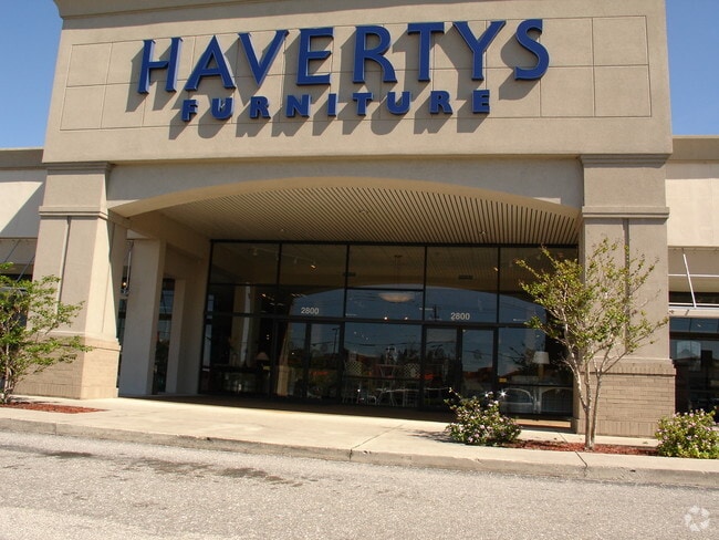
Property Record
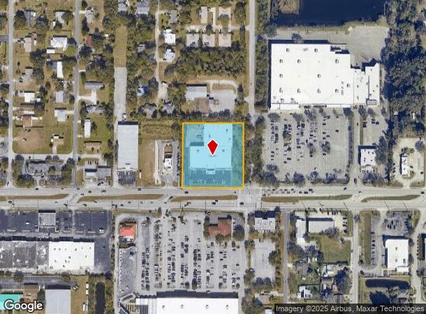
2800 W New Haven Ave, Melbourne, FL 32904
NEARBY LISTINGS FOR SALE OR LEASE
Property Detail
2800 W New Haven Ave
Palm Bay-Melbourne-Titusville, FL
Elton Hall Gdns, Resubd Of Pt Of
28-37-06-27-0000E.0-0001.00
ELTON HALL GDNS, RESUBD OF PT OF S 348.24 FT OF BLK E EX HWY R/W PAR 2.01,4.01
Storebuilding
Brevard
X
Florida
12009C0583G
1
2024
2.25 AC
2025
Brevard County
064601
Orlando
40,221 SF
DEMOGRAPHICS near 2800 W New Haven Ave
1 Mile
3 Mile
5 Mile
2024 Total Population
7,090
53,520
141,810
2029 Population
7,694
58,726
155,362
Pop Growth 2024-2029
+ 8.52%
+ 9.73%
+ 9.56%
Average Age
43
43
43
2024 Total Households
2,794
21,758
59,635
HH Growth 2024-2029
+ 8.23%
+ 9.59%
+ 9.42%
Median Household Inc
$73,773
$70,275
$57,884
Avg Household Size
2.40
2.30
2.30
2024 Avg HH Vehicles
2.00
2.00
2.00
Median Home Value
$309,213
$258,776
$231,159
Median Year Built
1981
1987
1986
Nearby Places
Map Layers
Map Styles
 Street
 Aerial
- Restaurants
- Banks
- Shops
- Fitness
- Groceries
PUBLIC TRANSPORTATION
AIRPORT
Melbourne Orlando International
DRIVE
WALK
Distance
Melbourne Orlando International
10 min
3.7 mi
Freight Ports
Port Canaveral
DRIVE
WALK
Distance
Port Canaveral
47 min
36.8 mi
Nearby Properties
Address
Land Use
TOTAL SIZE
Lot Size
Zoning
Address
Land Use
TOTAL SIZE
Lot Size
Zoning
1,245,196 SF
110.73 AC
I1
Address
Land Use
TOTAL SIZE
Lot Size
Zoning
433,669 SF
21.22 AC
AU
Address
Land Use
TOTAL SIZE
Lot Size
Zoning
506,643 SF
80 AC
RA
Address
Land Use
TOTAL SIZE
Lot Size
Zoning
380,944 SF
32.18 AC
RA
Address
Land Use
TOTAL SIZE
Lot Size
Zoning
458,852 SF
23.05 AC
GU
Address
Land Use
TOTAL SIZE
Lot Size
Zoning
391,740 SF
30 AC
Address
Land Use
TOTAL SIZE
Lot Size
Zoning
582,248 SF
65.30 AC
RA
Address
Land Use
TOTAL SIZE
Lot Size
Zoning
425,167 SF
43.33 AC
Address
Land Use
TOTAL SIZE
Lot Size
Zoning
475,791 SF
229.02 AC
M1
Address
Land Use
TOTAL SIZE
Lot Size
Zoning
265,272 SF
21.17 AC
M1
Address
Land Use
TOTAL SIZE
Lot Size
Zoning
265,062 SF
14.75 AC
M1
Address
Land Use
TOTAL SIZE
Lot Size
Zoning
384,430 SF
33.07 AC
R2
Address
Land Use
TOTAL SIZE
Lot Size
Zoning
389,175 SF
12.18 AC
Address
Land Use
TOTAL SIZE
Lot Size
Zoning
387,843 SF
27.19 AC
R3
Address
Land Use
TOTAL SIZE
Lot Size
Zoning
197,734 SF
27.99 AC
M1
Address
Land Use
TOTAL SIZE
Lot Size
Zoning
297,886 SF
32.38 AC
C-1
Address
Land Use
TOTAL SIZE
Lot Size
Zoning
261,552 SF
23.21 AC
R2
Address
Land Use
TOTAL SIZE
Lot Size
Zoning
268,487 SF
20.08 AC
RA
Address
Land Use
TOTAL SIZE
Lot Size
Zoning
280,518 SF
13.88 AC
Address
Land Use
TOTAL SIZE
Lot Size
Zoning
295,347 SF
14.61 AC
R2
Address
Land Use
TOTAL SIZE
Lot Size
Zoning
542,262 SF
51.88 AC
CP
Address
Land Use
TOTAL SIZE
Lot Size
Zoning
201,325 SF
11.41 AC
Address
Land Use
TOTAL SIZE
Lot Size
Zoning
226,121 SF
17.73 AC
Address
Land Use
TOTAL SIZE
Lot Size
Zoning
225,020 SF
24.25 AC
Address
Land Use
TOTAL SIZE
Lot Size
Zoning
74,716 SF
366.45 AC
M1
Address
Land Use
TOTAL SIZE
Lot Size
Zoning
182,494 SF
8.53 AC
CCP
Address
Land Use
TOTAL SIZE
Lot Size
Zoning
139,968 SF
23.46 AC
CRA
Address
Land Use
TOTAL SIZE
Lot Size
Zoning
205,564 SF
14.56 AC
M1
Address
Land Use
TOTAL SIZE
Lot Size
Zoning
188,927 SF
17.97 AC
CP
Address
Land Use
TOTAL SIZE
Lot Size
Zoning
175,610 SF
10.01 AC
CCP(15)
The World's #1 Commercial Real Estate Marketplace
Connect with us
© 2025 CoStar Group
The information above has been obtained from sources believed reliable. While we do not doubt its accuracy we have not verified it and make no guarantee, warranty or representation about it. It is your responsibility to independently confirm its accuracy and completeness. Any projections, opinions, assumptions, or estimates used are for example only and do not represent the current or future performance of the property. The value of this transaction to you depends on tax and other factors which should be evaluated by your tax, financial, and legal advisors. You and your advisors should conduct a careful, independent investigation of the property to determine to your satisfaction the suitability of the property for your needs.