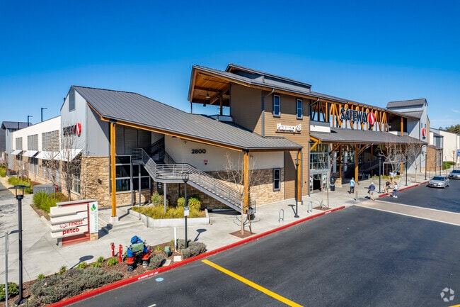
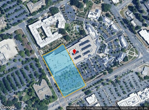
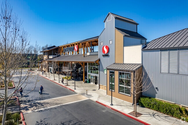
Property Record
2800 Ygnacio Valley Rd, Walnut Creek, CA 94598
NEARBY LISTINGS FOR SALE OR LEASE
Property Detail
2800 Ygnacio Valley Rd
143-170-008-5
Subdivision #9384
Regionalshoppingcenterormallwithanchorstore
T9384 L8
X
Contra Costa
06013C0292F
California
2025
4.23 AC
2025
Walnut Creek-Shadelands
338201
East Bay/Oakland
56,719 SF
Oakland-Hayward-Berkeley, CA
DEMOGRAPHICS near 2800 Ygnacio Valley Rd
1 Mile
3 Mile
5 Mile
2024 Total Population
12,066
118,332
264,072
2029 Population
12,034
117,682
262,345
Pop Growth 2024-2029
(0.27%)
(0.55%)
(0.65%)
Average Age
45
42
42
2024 Total Households
4,470
46,905
103,840
HH Growth 2024-2029
(0.25%)
(0.47%)
(0.60%)
Median Household Inc
$176,607
$125,910
$122,646
Avg Household Size
2.60
2.50
2.50
2024 Avg HH Vehicles
2.00
2.00
2.00
Median Home Value
$1,081,987
$886,886
$884,517
Median Year Built
1968
1973
1972
Nearby Places
Map Layers
Map Styles
 Street
 Aerial
- Restaurants
- Banks
- Shops
- Fitness
- Groceries
PUBLIC TRANSPORTATION
AIRPORT
Metro Oakland International
DRIVE
WALK
Distance
Metro Oakland International
39 min
27.2 mi
San Francisco International
DRIVE
WALK
Distance
San Francisco International
57 min
39.2 mi
Freight Ports
Port of Oakland
DRIVE
WALK
Distance
Port of Oakland
29 min
20.0 mi
Nearby Properties
Address
Land Use
TOTAL SIZE
Lot Size
Zoning
Address
Land Use
TOTAL SIZE
Lot Size
Zoning
Address
Land Use
TOTAL SIZE
Lot Size
Zoning
Address
Land Use
TOTAL SIZE
Lot Size
Zoning
155,176 SF
3.34 AC
Address
Land Use
TOTAL SIZE
Lot Size
Zoning
295,561 SF
3.80 AC
Address
Land Use
TOTAL SIZE
Lot Size
Zoning
337,980 SF
5.08 AC
Address
Land Use
TOTAL SIZE
Lot Size
Zoning
254,940 SF
1.61 AC
P1
Address
Land Use
TOTAL SIZE
Lot Size
Zoning
264,873 SF
2.19 AC
P1
Address
Land Use
TOTAL SIZE
Lot Size
Zoning
203,454 SF
2.33 AC
Address
Land Use
TOTAL SIZE
Lot Size
Zoning
5.52 AC
P1
Address
Land Use
TOTAL SIZE
Lot Size
Zoning
235,495 SF
2.51 AC
P1
Address
Land Use
TOTAL SIZE
Lot Size
Zoning
250,032 SF
7.95 AC
P1
Address
Land Use
TOTAL SIZE
Lot Size
Zoning
393,680 SF
2.29 AC
Address
Land Use
TOTAL SIZE
Lot Size
Zoning
157,352 SF
0.98 AC
Address
Land Use
TOTAL SIZE
Lot Size
Zoning
249,628 SF
3.64 AC
P1
Address
Land Use
TOTAL SIZE
Lot Size
Zoning
118,596 SF
1.20 AC
Address
Land Use
TOTAL SIZE
Lot Size
Zoning
192,387 SF
17.42 AC
M17
Address
Land Use
TOTAL SIZE
Lot Size
Zoning
12,864 SF
5.62 AC
Address
Land Use
TOTAL SIZE
Lot Size
Zoning
187,156 SF
5.92 AC
P1
Address
Land Use
TOTAL SIZE
Lot Size
Zoning
321,000 SF
3.26 AC
Address
Land Use
TOTAL SIZE
Lot Size
Zoning
100,627 SF
6.47 AC
Address
Land Use
TOTAL SIZE
Lot Size
Zoning
237,656 SF
7.16 AC
P1
Address
Land Use
TOTAL SIZE
Lot Size
Zoning
166,144 SF
19.22 AC
Address
Land Use
TOTAL SIZE
Lot Size
Zoning
45,744 SF
9.49 AC
Address
Land Use
TOTAL SIZE
Lot Size
Zoning
164,517 SF
3.65 AC
Address
Land Use
TOTAL SIZE
Lot Size
Zoning
109,261 SF
1.33 AC
Address
Land Use
TOTAL SIZE
Lot Size
Zoning
76,662 SF
1.37 AC
Address
Land Use
TOTAL SIZE
Lot Size
Zoning
80,813 SF
8.08 AC
Address
Land Use
TOTAL SIZE
Lot Size
Zoning
148,140 SF
4.28 AC
P1
Address
Land Use
TOTAL SIZE
Lot Size
Zoning
3,036 SF
11.11 AC
Address
Land Use
TOTAL SIZE
Lot Size
Zoning
22,152 SF
5.51 AC
The World's #1 Commercial Real Estate Marketplace
Connect with us
© 2025 CoStar Group
The information above has been obtained from sources believed reliable. While we do not doubt its accuracy we have not verified it and make no guarantee, warranty or representation about it. It is your responsibility to independently confirm its accuracy and completeness. Any projections, opinions, assumptions, or estimates used are for example only and do not represent the current or future performance of the property. The value of this transaction to you depends on tax and other factors which should be evaluated by your tax, financial, and legal advisors. You and your advisors should conduct a careful, independent investigation of the property to determine to your satisfaction the suitability of the property for your needs.