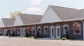
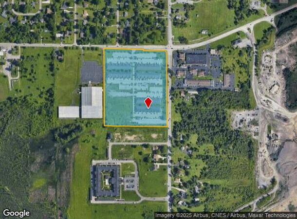
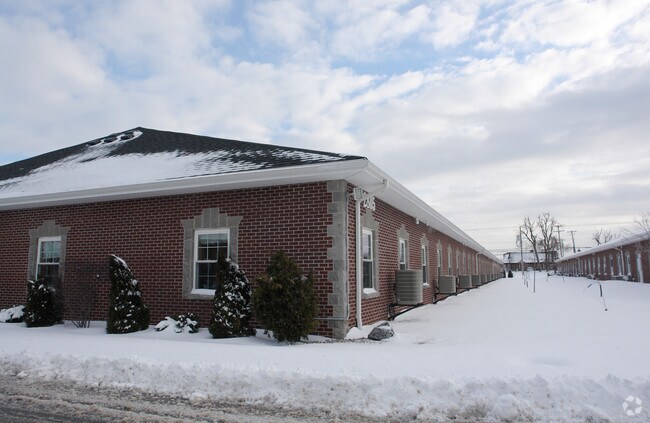
Property Record
2801 Wehrle Dr, Buffalo, NY 14221
NEARBY LISTINGS FOR SALE OR LEASE
Property Detail
2801 Wehrle Dr
145289 82.03-2-38.121
Erie
Officebuilding
New York
X
38.121
36029C0233H
13.55 AC
2024
East
2024
Buffalo/Niagara Falls
014208
Buffalo-Cheektowaga-Niagara Falls, NY
18,228 SF
DEMOGRAPHICS near 2801 Wehrle Dr
1 Mile
3 Mile
5 Mile
2024 Total Population
4,080
41,790
144,950
2029 Population
4,061
41,786
144,709
Pop Growth 2024-2029
(0.47%)
(0.01%)
(0.17%)
Average Age
44
44
44
2024 Total Households
1,775
17,480
61,735
HH Growth 2024-2029
(0.56%)
(0.09%)
(0.26%)
Median Household Inc
$89,642
$88,199
$81,334
Avg Household Size
2.20
2.30
2.30
2024 Avg HH Vehicles
2.00
2.00
2.00
Median Home Value
$247,565
$252,627
$236,713
Median Year Built
1962
1975
1967
Nearby Places
Map Layers
Map Styles
 Street
 Aerial
- Restaurants
- Banks
- Shops
- Fitness
- Groceries
PUBLIC TRANSPORTATION
COMMUTER RAIL
DRIVE
WALK
Distance
11 min
5.2 mi
DRIVE
WALK
Distance
13 min
5.7 mi
AIRPORT
Buffalo Niagara International
DRIVE
WALK
Distance
Buffalo Niagara International
9 min
4.1 mi
Niagara Falls International
DRIVE
WALK
Distance
Niagara Falls International
36 min
20.0 mi
Nearby Properties
Address
Land Use
TOTAL SIZE
Lot Size
Zoning
Address
Land Use
TOTAL SIZE
Lot Size
Zoning
868,362 SF
135.20 AC
Address
Land Use
TOTAL SIZE
Lot Size
Zoning
24,600 SF
19.20 AC
00000
Address
Land Use
TOTAL SIZE
Lot Size
Zoning
176,108 SF
20.04 AC
GB
Address
Land Use
TOTAL SIZE
Lot Size
Zoning
172,400 SF
116.50 AC
Address
Land Use
TOTAL SIZE
Lot Size
Zoning
82.29 AC
05C
Address
Land Use
TOTAL SIZE
Lot Size
Zoning
260,326 SF
22.70 AC
Address
Land Use
TOTAL SIZE
Lot Size
Zoning
203,546 SF
13.55 AC
Address
Land Use
TOTAL SIZE
Lot Size
Zoning
12,576 SF
18.15 AC
Address
Land Use
TOTAL SIZE
Lot Size
Zoning
8,296 SF
16.60 AC
Address
Land Use
TOTAL SIZE
Lot Size
Zoning
172,001 SF
23.49 AC
Address
Land Use
TOTAL SIZE
Lot Size
Zoning
7,744 SF
17.82 AC
Address
Land Use
TOTAL SIZE
Lot Size
Zoning
196,113 SF
21.09 AC
Address
Land Use
TOTAL SIZE
Lot Size
Zoning
54,109 SF
6.19 AC
OB
Address
Land Use
TOTAL SIZE
Lot Size
Zoning
6,618 SF
36.08 AC
MFMU
Address
Land Use
TOTAL SIZE
Lot Size
Zoning
19,558 SF
11.07 AC
Address
Land Use
TOTAL SIZE
Lot Size
Zoning
146,776 SF
9.19 AC
Address
Land Use
TOTAL SIZE
Lot Size
Zoning
19,640 SF
13.34 AC
00000
Address
Land Use
TOTAL SIZE
Lot Size
Zoning
320,945 SF
62.80 AC
RES
Address
Land Use
TOTAL SIZE
Lot Size
Zoning
108,824 SF
9.34 AC
Address
Land Use
TOTAL SIZE
Lot Size
Zoning
8,347 SF
14.04 AC
Address
Land Use
TOTAL SIZE
Lot Size
Zoning
5,912 SF
8.35 AC
Address
Land Use
TOTAL SIZE
Lot Size
Zoning
206,912 SF
26.41 AC
Address
Land Use
TOTAL SIZE
Lot Size
Zoning
150,539 SF
14.65 AC
05C
Address
Land Use
TOTAL SIZE
Lot Size
Zoning
96,501 SF
5.77 AC
Address
Land Use
TOTAL SIZE
Lot Size
Zoning
144,171 SF
17.40 AC
Address
Land Use
TOTAL SIZE
Lot Size
Zoning
1,760 SF
41.19 AC
05C
Address
Land Use
TOTAL SIZE
Lot Size
Zoning
134,702 SF
10.70 AC
00000
Address
Land Use
TOTAL SIZE
Lot Size
Zoning
Address
Land Use
TOTAL SIZE
Lot Size
Zoning
28,823 SF
0.66 AC
Address
Land Use
TOTAL SIZE
Lot Size
Zoning
113,828 SF
9.04 AC
The World's #1 Commercial Real Estate Marketplace
Connect with us
© 2026 CoStar Group
The information above has been obtained from sources believed reliable. While we do not doubt its accuracy we have not verified it and make no guarantee, warranty or representation about it. It is your responsibility to independently confirm its accuracy and completeness. Any projections, opinions, assumptions, or estimates used are for example only and do not represent the current or future performance of the property. The value of this transaction to you depends on tax and other factors which should be evaluated by your tax, financial, and legal advisors. You and your advisors should conduct a careful, independent investigation of the property to determine to your satisfaction the suitability of the property for your needs.