Property Record
2850 Tennyson Ave, Eugene, OR 97408

Property Detail
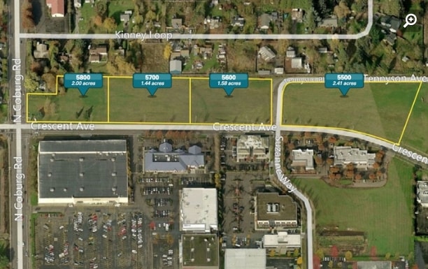
2850 Tennyson Ave
Eugene-Springfield, OR
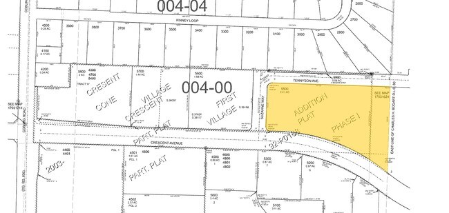
SUBDIVISION PLAT CRESCENT VILLAGE 1ST ADDITION LOT 10 TL 05500
1756855
LANE
Multifamilydwelling
Oregon
C-2
10
B and X Area of moderate flood hazard, usually the area between the limits of the 100-year and 500-year floods.
2.41 AC
2025
Lane County
2025
Portland
002204
NEARBY LISTINGS FOR SALE OR LEASE
DEMOGRAPHICS near 2850 Tennyson Ave
1 mile
3 mile
5 mile
2025 Total Population
10,402
60,061
181,200
2030 Population
10,263
59,473
180,121
Pop Growth 2025-2030
(1.34%)
(0.98%)
(0.60%)
Average Age
42
41
40
2025 Total Households
4,525
26,746
75,712
HH Growth 2025-2030
(1.39%)
(1.09%)
(0.73%)
Median Household Inc
$95,902
$74,358
$63,743
Avg Household Size
2.20
2.20
2.20
2025 Avg HH Vehicles
2.00
2.00
2.00
Median Home Value
$562,762
$494,056
$448,112
Median Year Built
1992
1984
1975
Nearby Places
Map Layers
Map Styles
 Street
 Aerial
Transit
 Traffic
 Biking
Places
Listings with unknown addresses are not visible on the map
- Restaurants
- Banks
- Shops
- Fitness
- Groceries
PUBLIC TRANSPORTATION
COMMUTER RAIL
Eugene (Amtrak Cascades - Amtrak, Coast Starlight - Amtrak)
Drive
Walk
Distance
Eugene (Amtrak Cascades - Amtrak, Coast Starlight - Amtrak)
7 min
3.7 mi
AIRPORT
Mahlon Sweet Field
Drive
Walk
Distance
Mahlon Sweet Field
17 min
9.0 mi
Freight Ports
Port of Coos Bay, OR
Drive
Walk
Distance
Port of Coos Bay, OR
157 min
112.6 mi
SALE & LEASE HISTORY
LISTING DATE
SALE/LEASE

Sep 24, 2016
For Sale
Nearby Properties
Address
Land Use
TOTAL SIZE
Lot Size
Zoning
Address
Land Use
TOTAL SIZE
Lot Size
Zoning
71.87 AC
PL
Address
Land Use
TOTAL SIZE
Lot Size
Zoning
12.42 AC
AG
Address
Land Use
TOTAL SIZE
Lot Size
Zoning
11.80 AC
PL
Address
Land Use
TOTAL SIZE
Lot Size
Zoning
16.80 AC
PL
Address
Land Use
TOTAL SIZE
Lot Size
Zoning
14.39 AC
E-1
Address
Land Use
TOTAL SIZE
Lot Size
Zoning
26.13 AC
E30
Address
Land Use
TOTAL SIZE
Lot Size
Zoning
9.59 AC
R-1
Address
Land Use
TOTAL SIZE
Lot Size
Zoning
14.54 AC
C-2
Address
Land Use
TOTAL SIZE
Lot Size
Zoning
Address
Land Use
TOTAL SIZE
Lot Size
Zoning
17.37 AC
AG
Address
Land Use
TOTAL SIZE
Lot Size
Zoning
15.95 AC
Address
Land Use
TOTAL SIZE
Lot Size
Zoning
25.78 AC
C-2
Address
Land Use
TOTAL SIZE
Lot Size
Zoning
13.55 AC
CI
Address
Land Use
TOTAL SIZE
Lot Size
Zoning
4.31 AC
C-2
Address
Land Use
TOTAL SIZE
Lot Size
Zoning
22.83 AC
PL
Address
Land Use
TOTAL SIZE
Lot Size
Zoning
Address
Land Use
TOTAL SIZE
Lot Size
Zoning
6.94 AC
PL
Address
Land Use
TOTAL SIZE
Lot Size
Zoning
8.69 AC
R-1
Address
Land Use
TOTAL SIZE
Lot Size
Zoning
12.53 AC
R-2
Address
Land Use
TOTAL SIZE
Lot Size
Zoning
5.70 AC
R-1
Address
Land Use
TOTAL SIZE
Lot Size
Zoning
14.09 AC
CI
Address
Land Use
TOTAL SIZE
Lot Size
Zoning
4.67 AC
PL
Address
Land Use
TOTAL SIZE
Lot Size
Zoning
4.85 AC
PL
Address
Land Use
TOTAL SIZE
Lot Size
Zoning
3,634 SF
6.34 AC
R-2
Address
Land Use
TOTAL SIZE
Lot Size
Zoning
5.38 AC
PL
Address
Land Use
TOTAL SIZE
Lot Size
Zoning
12.36 AC
C-1
Address
Land Use
TOTAL SIZE
Lot Size
Zoning
5.98 AC
PL
Address
Land Use
TOTAL SIZE
Lot Size
Zoning
7.38 AC
C-2
Address
Land Use
TOTAL SIZE
Lot Size
Zoning
11.77 AC
R-3
Address
Land Use
TOTAL SIZE
Lot Size
Zoning
0.97 AC
PL
The World's #1 Commercial Real Estate Marketplace
Connect with us
© 2026 CoStar Group
The information above has been obtained from sources believed reliable. While we do not doubt its accuracy we have not verified it and make no guarantee, warranty or representation about it. It is your responsibility to independently confirm its accuracy and completeness. Any projections, opinions, assumptions, or estimates used are for example only and do not represent the current or future performance of the property. The value of this transaction to you depends on tax and other factors which should be evaluated by your tax, financial, and legal advisors. You and your advisors should conduct a careful, independent investigation of the property to determine to your satisfaction the suitability of the property for your needs.