Property Record
2801 Dundee Rd, Northbrook, IL 60062


Save to a Folder
{{folder.Name}}
{{folder.ListingIds.length}} Properties
{{folder.ListingIds.length}} Property
Create a New Folder
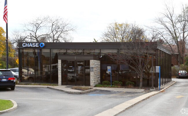
Property Detail
2801 Dundee Rd
04-08-201-033-0000
Cook
Financialbuilding
Illinois
B and X Area of moderate flood hazard, usually the area between the limits of the 100-year and 500-year floods.
0.52 AC
2023
Central North
2025
Chicago
801605
Chicago-Naperville-Elgin, IL-IN
3,762 SF
NEARBY LISTINGS FOR SALE OR LEASE
DEMOGRAPHICS near 2801 Dundee Rd
1 mile
3 mile
5 mile
2025 Total Population
8,456
72,716
210,716
2030 Population
8,528
73,483
212,989
Pop Growth 2025-2030
+ 0.85%
+ 1.05%
+ 1.08%
Average Age
44
45
44
2025 Total Households
3,087
27,501
78,803
HH Growth 2025-2030
+ 0.78%
+ 0.92%
+ 0.99%
Median Household Inc
$165,277
$152,824
$125,575
Avg Household Size
2.70
2.60
2.60
2025 Avg HH Vehicles
2.00
2.00
2.00
Median Home Value
$703,264
$646,126
$569,039
Median Year Built
1974
1974
1974
Nearby Places
Map Layers
Map Styles
 Street
 Aerial
Layers
 Traffic
 Biking
Places
Listings with unknown addresses are not visible on the map
- Restaurants
- Banks
- Shops
- Fitness
- Groceries
PUBLIC TRANSPORTATION
COMMUTER RAIL
Lake Cook Station (Milwaukee District North Line - Northeast Illinois Regional Commuter Railroad (Metra))
Drive
Walk
Distance
Lake Cook Station (Milwaukee District North Line - Northeast Illinois Regional Commuter Railroad (Metra))
5 min
1.5 mi
Northbrook Station (Milwaukee District North Line - Northeast Illinois Regional Commuter Railroad (Metra))
Drive
Walk
Distance
Northbrook Station (Milwaukee District North Line - Northeast Illinois Regional Commuter Railroad (Metra))
6 min
2.1 mi
AIRPORT
Chicago O'Hare International
Drive
Walk
Distance
Chicago O'Hare International
44 min
19.2 mi
Chicago Midway International
Drive
Walk
Distance
Chicago Midway International
52 min
31.3 mi
Nearby Properties
Address
Land Use
TOTAL SIZE
Lot Size
Zoning
Address
Land Use
TOTAL SIZE
Lot Size
Zoning
6,783,684 SF
69.84 AC
Address
Land Use
TOTAL SIZE
Lot Size
Zoning
78,600 SF
9.20 AC
Address
Land Use
TOTAL SIZE
Lot Size
Zoning
815,308 SF
12.95 AC
Address
Land Use
TOTAL SIZE
Lot Size
Zoning
708,522 SF
17.11 AC
Address
Land Use
TOTAL SIZE
Lot Size
Zoning
864,590 SF
2.64 AC
Address
Land Use
TOTAL SIZE
Lot Size
Zoning
530,208 SF
Address
Land Use
TOTAL SIZE
Lot Size
Zoning
732,143 SF
57.63 AC
Address
Land Use
TOTAL SIZE
Lot Size
Zoning
21.58 AC
Address
Land Use
TOTAL SIZE
Lot Size
Zoning
8.04 AC
Address
Land Use
TOTAL SIZE
Lot Size
Zoning
1,049,337 SF
24.57 AC
Address
Land Use
TOTAL SIZE
Lot Size
Zoning
241,179 SF
8.02 AC
Address
Land Use
TOTAL SIZE
Lot Size
Zoning
653,040 SF
7.96 AC
Address
Land Use
TOTAL SIZE
Lot Size
Zoning
301,050 SF
11.22 AC
Address
Land Use
TOTAL SIZE
Lot Size
Zoning
419,812 SF
13.88 AC
Address
Land Use
TOTAL SIZE
Lot Size
Zoning
333,202 SF
13.88 AC
Address
Land Use
TOTAL SIZE
Lot Size
Zoning
629,447 SF
3.96 AC
Address
Land Use
TOTAL SIZE
Lot Size
Zoning
534,816 SF
6.98 AC
Address
Land Use
TOTAL SIZE
Lot Size
Zoning
443,916 SF
5.61 AC
Address
Land Use
TOTAL SIZE
Lot Size
Zoning
142,300 SF
13.16 AC
Address
Land Use
TOTAL SIZE
Lot Size
Zoning
33.60 AC
Address
Land Use
TOTAL SIZE
Lot Size
Zoning
186,646 SF
26.69 AC
Address
Land Use
TOTAL SIZE
Lot Size
Zoning
394,232 SF
6.31 AC
Address
Land Use
TOTAL SIZE
Lot Size
Zoning
349,846 SF
5.11 AC
Address
Land Use
TOTAL SIZE
Lot Size
Zoning
221,786 SF
6.33 AC
Address
Land Use
TOTAL SIZE
Lot Size
Zoning
143,087 SF
11.20 AC
Address
Land Use
TOTAL SIZE
Lot Size
Zoning
189,667 SF
6.65 AC
Address
Land Use
TOTAL SIZE
Lot Size
Zoning
8,586,994 SF
10.41 AC
Address
Land Use
TOTAL SIZE
Lot Size
Zoning
2,168,130 SF
16 AC
Address
Land Use
TOTAL SIZE
Lot Size
Zoning
8.89 AC
Address
Land Use
TOTAL SIZE
Lot Size
Zoning
141,340 SF
7.18 AC
The World's #1 Commercial Real Estate Marketplace
Connect with us
© 2026 CoStar Group
The information above has been obtained from sources believed reliable. While we do not doubt its accuracy we have not verified it and make no guarantee, warranty or representation about it. It is your responsibility to independently confirm its accuracy and completeness. Any projections, opinions, assumptions, or estimates used are for example only and do not represent the current or future performance of the property. The value of this transaction to you depends on tax and other factors which should be evaluated by your tax, financial, and legal advisors. You and your advisors should conduct a careful, independent investigation of the property to determine to your satisfaction the suitability of the property for your needs.