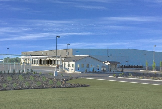
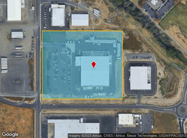
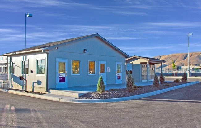
Property Record
2801 Goodman Rd, Yakima, WA 98903
NEARBY LISTINGS FOR SALE OR LEASE
Property Detail
2801 Goodman Rd
191206-32007
SECTION 06 TOWNSHIP 12 RANGE 19 QUARTER SW: N 597 FT OF W 708 FT OF PARCEL B ROS 7636224 AND APPROVED BY UNION GAP SPE 4/1/14
Transportationcommunicationsgeneral
Yakima
X
Washington
53077C1042F
9.70 AC
2025
Union Gap
2025
Yakima
001300
Yakima, WA
67,192 SF
DEMOGRAPHICS near 2801 Goodman Rd
1 Mile
3 Mile
5 Mile
2024 Total Population
2,048
37,058
99,420
2029 Population
2,065
37,083
99,891
Pop Growth 2024-2029
+ 0.83%
+ 0.07%
+ 0.47%
Average Age
37
34
36
2024 Total Households
728
12,005
35,805
HH Growth 2024-2029
+ 0.82%
(0.03%)
+ 0.49%
Median Household Inc
$43,571
$48,420
$51,018
Avg Household Size
2.70
3.00
2.60
2024 Avg HH Vehicles
2.00
2.00
2.00
Median Home Value
$159,482
$174,664
$230,666
Median Year Built
1972
1965
1970
Nearby Places
- Restaurants
- Banks
- Shops
- Fitness
- Groceries
PUBLIC TRANSPORTATION
AIRPORT
Yakima Air Trml/McAllister Field
DRIVE
WALK
Distance
Yakima Air Trml/McAllister Field
8 min
2.9 mi
Freight Ports
Port of Tacoma
DRIVE
WALK
Distance
Port of Tacoma
191 min
160.4 mi
Nearby Properties
Address
Land Use
TOTAL SIZE
Lot Size
Zoning
Address
Land Use
TOTAL SIZE
Lot Size
Zoning
390,527 SF
11.86 AC
R3
Address
Land Use
TOTAL SIZE
Lot Size
Zoning
347,665 SF
37.77 AC
B2
Address
Land Use
TOTAL SIZE
Lot Size
Zoning
208,322 SF
3.69 AC
PUB
Address
Land Use
TOTAL SIZE
Lot Size
Zoning
106,878 SF
3.46 AC
RD
Address
Land Use
TOTAL SIZE
Lot Size
Zoning
82,436 SF
11 AC
RD
Address
Land Use
TOTAL SIZE
Lot Size
Zoning
345,698 SF
3.52 AC
C1
Address
Land Use
TOTAL SIZE
Lot Size
Zoning
100,992 SF
9.15 AC
RD
Address
Land Use
TOTAL SIZE
Lot Size
Zoning
91,856 SF
9.17 AC
RD
Address
Land Use
TOTAL SIZE
Lot Size
Zoning
162,216 SF
11 AC
M1
Address
Land Use
TOTAL SIZE
Lot Size
Zoning
57,009 SF
212.58 AC
AS
Address
Land Use
TOTAL SIZE
Lot Size
Zoning
64,171 SF
48.08 AC
PUB
Address
Land Use
TOTAL SIZE
Lot Size
Zoning
158,890 SF
13.84 AC
B2
Address
Land Use
TOTAL SIZE
Lot Size
Zoning
135,634 SF
9.84 AC
C1
Address
Land Use
TOTAL SIZE
Lot Size
Zoning
325,959 SF
11.95 AC
M2
Address
Land Use
TOTAL SIZE
Lot Size
Zoning
80,374 SF
8.99 AC
C1
Address
Land Use
TOTAL SIZE
Lot Size
Zoning
114,406 SF
15.50 AC
PUB
Address
Land Use
TOTAL SIZE
Lot Size
Zoning
151,831 SF
21.08 AC
M1
Address
Land Use
TOTAL SIZE
Lot Size
Zoning
43,687 SF
3.33 AC
C1
Address
Land Use
TOTAL SIZE
Lot Size
Zoning
195,753 SF
11.66 AC
M1
Address
Land Use
TOTAL SIZE
Lot Size
Zoning
82,422 SF
4.58 AC
C1
Address
Land Use
TOTAL SIZE
Lot Size
Zoning
65,602 SF
10 AC
AS
Address
Land Use
TOTAL SIZE
Lot Size
Zoning
123,690 SF
12.02 AC
M1
Address
Land Use
TOTAL SIZE
Lot Size
Zoning
9,121 SF
0.22 AC
C1
Address
Land Use
TOTAL SIZE
Lot Size
Zoning
71,728 SF
2.96 AC
LCC
Address
Land Use
TOTAL SIZE
Lot Size
Zoning
117,962 SF
2.93 AC
BCOM
Address
Land Use
TOTAL SIZE
Lot Size
Zoning
34,271 SF
5.87 AC
B2
Address
Land Use
TOTAL SIZE
Lot Size
Zoning
138,550 SF
10.20 AC
M1
Address
Land Use
TOTAL SIZE
Lot Size
Zoning
48,952 SF
3.67 AC
SCC
Address
Land Use
TOTAL SIZE
Lot Size
Zoning
110,526 SF
9.70 AC
C1
Address
Land Use
TOTAL SIZE
Lot Size
Zoning
70,724 SF
1.34 AC
C1
The World's #1 Commercial Real Estate Marketplace
Connect with us
© 2025 CoStar Group
The information above has been obtained from sources believed reliable. While we do not doubt its accuracy we have not verified it and make no guarantee, warranty or representation about it. It is your responsibility to independently confirm its accuracy and completeness. Any projections, opinions, assumptions, or estimates used are for example only and do not represent the current or future performance of the property. The value of this transaction to you depends on tax and other factors which should be evaluated by your tax, financial, and legal advisors. You and your advisors should conduct a careful, independent investigation of the property to determine to your satisfaction the suitability of the property for your needs.