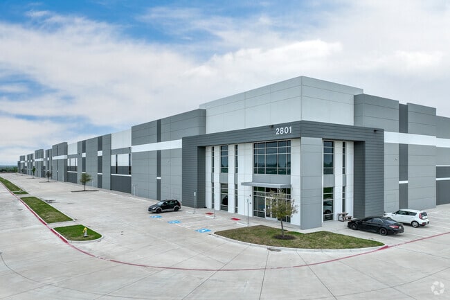
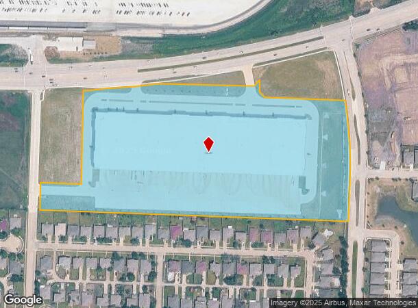
Property Record
2801 N Highway 78, Wylie, TX 75098

Current Lease Availabilities
Property Detail
2801 N Highway 78
Dallas-Fort Worth-Arlington, TX
LI 78 LOGISTICS CENTER, BLK A, LOT 1
R-12810-00A-0010-1
COLLIN
Commercialnec
Texas
PD
1
2025
18.40 AC
2025
Plano
031308
Dallas/Ft Worth
274,416 SF
NEARBY LISTINGS FOR SALE OR LEASE
DEMOGRAPHICS near 2801 N Highway 78
1 mile
3 mile
5 mile
2025 Total Population
4,163
29,933
96,831
2030 Population
4,778
34,322
111,534
Pop Growth 2025-2030
+ 14.77%
+ 14.66%
+ 15.18%
Average Age
36
37
37
2025 Total Households
1,279
9,718
30,982
HH Growth 2025-2030
+ 14.93%
+ 14.81%
+ 15.39%
Median Household Inc
$131,118
$125,868
$121,324
Avg Household Size
3.20
3.10
3.10
2025 Avg HH Vehicles
2.00
2.00
2.00
Median Home Value
$421,428
$410,587
$442,159
Median Year Built
2007
2006
2007
Nearby Places
Map Layers
Map Styles
 Street
 Aerial
Layers
 Traffic
 Biking
Places
Listings with unknown addresses are not visible on the map
- Restaurants
- Banks
- Shops
- Fitness
- Groceries
PUBLIC TRANSPORTATION
AIRPORT
Dallas Love Field
Drive
Walk
Distance
Dallas Love Field
48 min
32.2 mi
Freight Ports
Port of Shreveport
Drive
Walk
Distance
Port of Shreveport
220 min
194.1 mi
Nearby Properties
Address
Land Use
TOTAL SIZE
Lot Size
Zoning
Address
Land Use
TOTAL SIZE
Lot Size
Zoning
603,573 SF
58.20 AC
Address
Land Use
TOTAL SIZE
Lot Size
Zoning
393,054 SF
55.95 AC
Address
Land Use
TOTAL SIZE
Lot Size
Zoning
132,306 SF
7.85 AC
MF
Address
Land Use
TOTAL SIZE
Lot Size
Zoning
106,866 SF
15.69 AC
Address
Land Use
TOTAL SIZE
Lot Size
Zoning
97,898 SF
10.82 AC
Address
Land Use
TOTAL SIZE
Lot Size
Zoning
203,192 SF
17.69 AC
Address
Land Use
TOTAL SIZE
Lot Size
Zoning
128,849 SF
7.70 AC
Address
Land Use
TOTAL SIZE
Lot Size
Zoning
304,978 SF
81.51 AC
Address
Land Use
TOTAL SIZE
Lot Size
Zoning
88,580 SF
38.80 AC
Address
Land Use
TOTAL SIZE
Lot Size
Zoning
145,635 SF
12.15 AC
Address
Land Use
TOTAL SIZE
Lot Size
Zoning
151,759 SF
14.02 AC
MF
Address
Land Use
TOTAL SIZE
Lot Size
Zoning
54,240 SF
2.12 AC
MF
Address
Land Use
TOTAL SIZE
Lot Size
Zoning
33,638 SF
7.14 AC
AG
Address
Land Use
TOTAL SIZE
Lot Size
Zoning
67,031 SF
18.83 AC
Address
Land Use
TOTAL SIZE
Lot Size
Zoning
108,582 SF
10 AC
Address
Land Use
TOTAL SIZE
Lot Size
Zoning
88,452 SF
7.96 AC
Address
Land Use
TOTAL SIZE
Lot Size
Zoning
65,987 SF
4.99 AC
Address
Land Use
TOTAL SIZE
Lot Size
Zoning
74,124 SF
14.57 AC
Address
Land Use
TOTAL SIZE
Lot Size
Zoning
15,972 SF
1.96 AC
Address
Land Use
TOTAL SIZE
Lot Size
Zoning
9,952 SF
5.55 AC
PD
Address
Land Use
TOTAL SIZE
Lot Size
Zoning
14,921 SF
1.52 AC
PD
Address
Land Use
TOTAL SIZE
Lot Size
Zoning
59,150 SF
5.13 AC
Address
Land Use
TOTAL SIZE
Lot Size
Zoning
19,130 SF
2.23 AC
Address
Land Use
TOTAL SIZE
Lot Size
Zoning
24,739 SF
40.55 AC
Address
Land Use
TOTAL SIZE
Lot Size
Zoning
41.86 AC
Address
Land Use
TOTAL SIZE
Lot Size
Zoning
1 SF
48.95 AC
Address
Land Use
TOTAL SIZE
Lot Size
Zoning
2,000,000 SF
5.68 AC
Address
Land Use
TOTAL SIZE
Lot Size
Zoning
5,753 SF
2.24 AC
PD
Address
Land Use
TOTAL SIZE
Lot Size
Zoning
14,245 SF
3.74 AC
The World's #1 Commercial Real Estate Marketplace
Connect with us
© 2026 CoStar Group
The information above has been obtained from sources believed reliable. While we do not doubt its accuracy we have not verified it and make no guarantee, warranty or representation about it. It is your responsibility to independently confirm its accuracy and completeness. Any projections, opinions, assumptions, or estimates used are for example only and do not represent the current or future performance of the property. The value of this transaction to you depends on tax and other factors which should be evaluated by your tax, financial, and legal advisors. You and your advisors should conduct a careful, independent investigation of the property to determine to your satisfaction the suitability of the property for your needs.