Property Record
2801 Troxler Rd, Burlington, NC 27215

Save to a Folder
{{folder.Name}}
{{folder.ListingIds.length}} Properties
{{folder.ListingIds.length}} Property
Create a New Folder
Property Detail
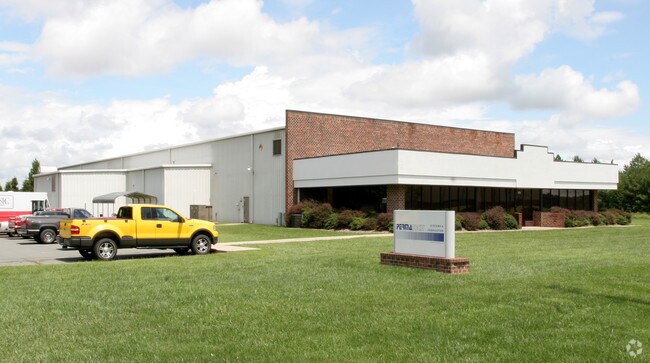
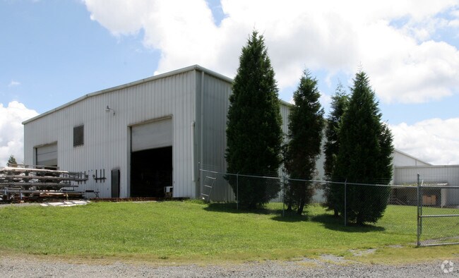
2801 Troxler Rd
112122
WILLOW SPRINGS FARM LOT 1 3-22E-23
Warehouse
Alamance
I 1
North Carolina
B and X Area of moderate flood hazard, usually the area between the limits of the 100-year and 500-year floods.
1
2025
5 AC
2025
West Burlington/Airport
021703
Greensboro/Winston-Salem
28,350 SF
Burlington, NC
NEARBY LISTINGS FOR SALE OR LEASE
DEMOGRAPHICS near 2801 Troxler Rd
1 mile
3 mile
5 mile
2025 Total Population
2,478
26,015
78,789
2030 Population
2,649
27,449
82,868
Pop Growth 2025-2030
+ 6.90%
+ 5.51%
+ 5.18%
Average Age
41
41
41
2025 Total Households
1,122
11,399
32,135
HH Growth 2025-2030
+ 7.04%
+ 5.63%
+ 5.37%
Median Household Inc
$72,224
$67,776
$65,046
Avg Household Size
2.20
2.20
2.30
2025 Avg HH Vehicles
2.00
2.00
2.00
Median Home Value
$316,514
$319,883
$280,409
Median Year Built
2002
1993
1986
Nearby Places
Map Layers
Map Styles
 Street
 Aerial
Layers
 Traffic
 Biking
Places
Listings with unknown addresses are not visible on the map
- Restaurants
- Banks
- Shops
- Fitness
- Groceries
PUBLIC TRANSPORTATION
COMMUTER RAIL
Burlington Station (Piedmont - North Carolina by Train (NC Train))
Drive
Walk
Distance
Burlington Station (Piedmont - North Carolina by Train (NC Train))
11 min
5.0 mi
AIRPORT
Piedmont Triad International
Drive
Walk
Distance
Piedmont Triad International
45 min
32.9 mi
Nearby Properties
Address
Land Use
TOTAL SIZE
Lot Size
Zoning
Address
Land Use
TOTAL SIZE
Lot Size
Zoning
350,000 SF
64.18 AC
O I
Address
Land Use
TOTAL SIZE
Lot Size
Zoning
81,153 SF
62.10 AC
X 1
Address
Land Use
TOTAL SIZE
Lot Size
Zoning
26,280 SF
14.34 AC
R 15
Address
Land Use
TOTAL SIZE
Lot Size
Zoning
41,892 SF
21.63 AC
CR
Address
Land Use
TOTAL SIZE
Lot Size
Zoning
26,280 SF
11.24 AC
CR
Address
Land Use
TOTAL SIZE
Lot Size
Zoning
51,381 SF
34.69 AC
CB
Address
Land Use
TOTAL SIZE
Lot Size
Zoning
10,368 SF
13.60 AC
MFA
Address
Land Use
TOTAL SIZE
Lot Size
Zoning
10,744 SF
24.60 AC
MF A
Address
Land Use
TOTAL SIZE
Lot Size
Zoning
27,803 SF
8.80 AC
CR
Address
Land Use
TOTAL SIZE
Lot Size
Zoning
47,520 SF
6.10 AC
B 2
Address
Land Use
TOTAL SIZE
Lot Size
Zoning
23,265 SF
20.45 AC
MF A
Address
Land Use
TOTAL SIZE
Lot Size
Zoning
135,186 SF
15.60 AC
CR
Address
Land Use
TOTAL SIZE
Lot Size
Zoning
12,600 SF
44.61 AC
Address
Land Use
TOTAL SIZE
Lot Size
Zoning
28,812 SF
15.63 AC
MFA
Address
Land Use
TOTAL SIZE
Lot Size
Zoning
84,783 SF
32.88 AC
CB
Address
Land Use
TOTAL SIZE
Lot Size
Zoning
203,832 SF
36.10 AC
B 2
Address
Land Use
TOTAL SIZE
Lot Size
Zoning
10,384 SF
16.51 AC
B2
Address
Land Use
TOTAL SIZE
Lot Size
Zoning
14,760 SF
13.07 AC
MFA
Address
Land Use
TOTAL SIZE
Lot Size
Zoning
10,604 SF
24.43 AC
R 9
Address
Land Use
TOTAL SIZE
Lot Size
Zoning
53,012 SF
18.58 AC
B 2
Address
Land Use
TOTAL SIZE
Lot Size
Zoning
90,767 SF
36.47 AC
I 1
Address
Land Use
TOTAL SIZE
Lot Size
Zoning
714,245 SF
109.43 AC
I 1
Address
Land Use
TOTAL SIZE
Lot Size
Zoning
81,726 SF
18.01 AC
R 15
Address
Land Use
TOTAL SIZE
Lot Size
Zoning
80,865 SF
76.02 AC
I 1A
Address
Land Use
TOTAL SIZE
Lot Size
Zoning
29,057 SF
10.99 AC
B2
Address
Land Use
TOTAL SIZE
Lot Size
Zoning
90,083 SF
2.33 AC
CB
Address
Land Use
TOTAL SIZE
Lot Size
Zoning
26,280 SF
9.64 AC
R15
Address
Land Use
TOTAL SIZE
Lot Size
Zoning
9,672 SF
10.77 AC
MF A
Address
Land Use
TOTAL SIZE
Lot Size
Zoning
43,680 SF
5.77 AC
Address
Land Use
TOTAL SIZE
Lot Size
Zoning
370,000 SF
24.09 AC
B 2
The World's #1 Commercial Real Estate Marketplace
Connect with us
© 2026 CoStar Group
The information above has been obtained from sources believed reliable. While we do not doubt its accuracy we have not verified it and make no guarantee, warranty or representation about it. It is your responsibility to independently confirm its accuracy and completeness. Any projections, opinions, assumptions, or estimates used are for example only and do not represent the current or future performance of the property. The value of this transaction to you depends on tax and other factors which should be evaluated by your tax, financial, and legal advisors. You and your advisors should conduct a careful, independent investigation of the property to determine to your satisfaction the suitability of the property for your needs.