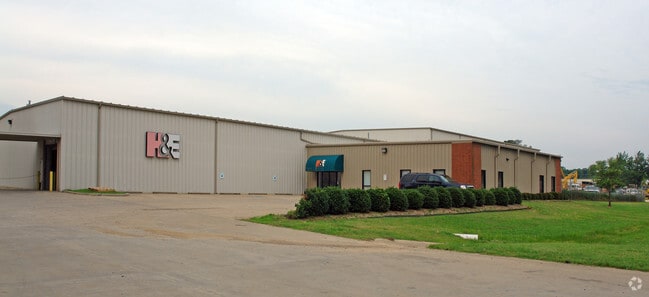
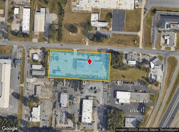
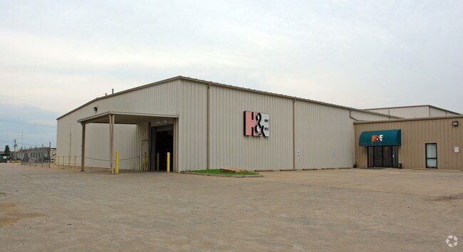
Property Record
2801 W 65Th St, Little Rock, AR 72209

NEARBY LISTINGS FOR SALE OR LEASE
Property Detail
2801 W 65Th St
Little Rock-North Little Rock-Conway, AR
L R Ind Dist
34L-339-00-074-01
PT TR 31 MPDA COM AT THE NE COR SE1/4 TH S0*16'32"W30' AL THE ELN SE1/4 TO A PT ON THE S R/W OF W 65TH ST SD PT ALSO BEING THE NE COR OF TR 31 TH N89*18'00"W450' AL SD S R/W LN TO THE POB TH CONT N89*18'00"W680.05' AL SD S R/W LN TO THE NE COR TR 57
Autorepair
Pulaski
X
Arkansas
05119C0458G
31
2025
4.69 AC
2025
Southwest
002002
Little Rock/N Little Rock
5,920 SF
DEMOGRAPHICS near 2801 W 65Th St
1 Mile
3 Mile
5 Mile
2024 Total Population
251
36,043
102,724
2029 Population
255
36,695
103,974
Pop Growth 2024-2029
+ 1.59%
+ 1.81%
+ 1.22%
Average Age
37
36
38
2024 Total Households
92
13,617
42,923
HH Growth 2024-2029
+ 1.09%
+ 2.23%
+ 1.34%
Median Household Inc
$39,999
$34,697
$41,177
Avg Household Size
2.50
2.40
2.20
2024 Avg HH Vehicles
2.00
2.00
2.00
Median Home Value
$131,250
$76,325
$118,627
Median Year Built
1979
1972
1969
Nearby Places
Map Layers
Map Styles
 Street
 Aerial
- Restaurants
- Banks
- Shops
- Fitness
- Groceries
PUBLIC TRANSPORTATION
COMMUTER RAIL
DRIVE
WALK
Distance
10 min
6.9 mi
AIRPORT
Bill and Hillary Clinton Ntl/Adams Field
DRIVE
WALK
Distance
Bill and Hillary Clinton Ntl/Adams Field
10 min
6.7 mi
Nearby Properties
Address
Land Use
TOTAL SIZE
Lot Size
Zoning
Address
Land Use
TOTAL SIZE
Lot Size
Zoning
10 SF
29.02 AC
Address
Land Use
TOTAL SIZE
Lot Size
Zoning
88,687 SF
1.67 AC
Address
Land Use
TOTAL SIZE
Lot Size
Zoning
79,751 SF
28.57 AC
Address
Land Use
TOTAL SIZE
Lot Size
Zoning
239,345 SF
19.70 AC
Address
Land Use
TOTAL SIZE
Lot Size
Zoning
34,925 SF
12.59 AC
Address
Land Use
TOTAL SIZE
Lot Size
Zoning
83,466 SF
5.46 AC
Address
Land Use
TOTAL SIZE
Lot Size
Zoning
41,652 SF
10.86 AC
Address
Land Use
TOTAL SIZE
Lot Size
Zoning
50,433 SF
22.23 AC
Address
Land Use
TOTAL SIZE
Lot Size
Zoning
24,492 SF
8.92 AC
Address
Land Use
TOTAL SIZE
Lot Size
Zoning
131,278 SF
6.37 AC
Address
Land Use
TOTAL SIZE
Lot Size
Zoning
139,410 SF
8.35 AC
Address
Land Use
TOTAL SIZE
Lot Size
Zoning
24,520 SF
10.92 AC
Address
Land Use
TOTAL SIZE
Lot Size
Zoning
6,161 SF
40.08 AC
Address
Land Use
TOTAL SIZE
Lot Size
Zoning
182,636 SF
16.86 AC
Address
Land Use
TOTAL SIZE
Lot Size
Zoning
152,350 SF
13.57 AC
Address
Land Use
TOTAL SIZE
Lot Size
Zoning
75,900 SF
20.18 AC
Address
Land Use
TOTAL SIZE
Lot Size
Zoning
35,069 SF
43.11 AC
Address
Land Use
TOTAL SIZE
Lot Size
Zoning
59,076 SF
22.27 AC
Address
Land Use
TOTAL SIZE
Lot Size
Zoning
345,000 SF
13.21 AC
Address
Land Use
TOTAL SIZE
Lot Size
Zoning
33,216 SF
12.59 AC
Address
Land Use
TOTAL SIZE
Lot Size
Zoning
41,291 SF
1.73 AC
Address
Land Use
TOTAL SIZE
Lot Size
Zoning
85,458 SF
9.86 AC
Address
Land Use
TOTAL SIZE
Lot Size
Zoning
10,629 SF
12 AC
Address
Land Use
TOTAL SIZE
Lot Size
Zoning
62,326 SF
5.84 AC
Address
Land Use
TOTAL SIZE
Lot Size
Zoning
573,416 SF
57.83 AC
Address
Land Use
TOTAL SIZE
Lot Size
Zoning
2,881 SF
14.04 AC
Address
Land Use
TOTAL SIZE
Lot Size
Zoning
58,156 SF
4.35 AC
Address
Land Use
TOTAL SIZE
Lot Size
Zoning
1,233 SF
6.19 AC
Address
Land Use
TOTAL SIZE
Lot Size
Zoning
38,640 SF
11.48 AC
Address
Land Use
TOTAL SIZE
Lot Size
Zoning
27,760 SF
9.95 AC
The World's #1 Commercial Real Estate Marketplace
Connect with us
© 2026 CoStar Group
The information above has been obtained from sources believed reliable. While we do not doubt its accuracy we have not verified it and make no guarantee, warranty or representation about it. It is your responsibility to independently confirm its accuracy and completeness. Any projections, opinions, assumptions, or estimates used are for example only and do not represent the current or future performance of the property. The value of this transaction to you depends on tax and other factors which should be evaluated by your tax, financial, and legal advisors. You and your advisors should conduct a careful, independent investigation of the property to determine to your satisfaction the suitability of the property for your needs.