Property Record
28014 Wesley Chapel Blvd, Wesley Chapel, FL 33543
NEARBY LISTINGS FOR SALE OR LEASE
-
-
-
-
27327-27424 Wesley Chapel Blvd
Wesley Chapel, FL 33544
$22.00 - $34.50 SF/YR
1,512 - 4,200 SF
Retail
-
-
-
-
View all Wesley Chapel listings for sale on LoopNet.com
Property Detail
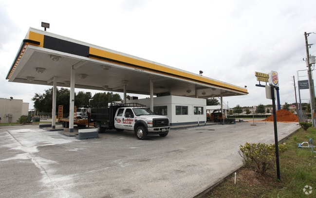
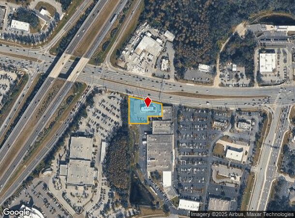
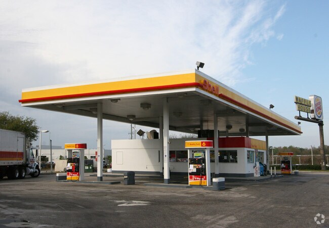
28014 Wesley Chapel Blvd
Tampa-St. Petersburg-Clearwater, FL
S.R. 54 Just East And West Of I - 75
07-26-20-0000-00300-0040
COM AT SW COR OF SW1/4 TH N01 DEG 0229W ALG WEST BDY OF SW1/4 2555.52 FT TO POINT ON SLY R/W LINE OF SR NO 54 TH S78DEG 5021E ALG SAID R/W LINE 15.35 FT FOR POB TH S78DEG 5021E 240.77 FT ALG SAID R/W LINE TH S01DEG 02 29E 157.63 FT TH S88DEG 57 31W 1
Restaurantdrivein
Pasco
AE
Florida
12101C0426F
4
2024
0.77 AC
2025
Pasco County
032106
Tampa/St Petersburg
2,886 SF
DEMOGRAPHICS near 28014 Wesley Chapel Blvd
1 Mile
3 Mile
5 Mile
2024 Total Population
4,775
40,377
99,968
2029 Population
5,775
48,813
120,562
Pop Growth 2024-2029
+ 20.94%
+ 20.89%
+ 20.60%
Average Age
38
38
38
2024 Total Households
1,651
13,888
35,041
HH Growth 2024-2029
+ 20.90%
+ 20.85%
+ 20.51%
Median Household Inc
$101,377
$103,820
$100,295
Avg Household Size
2.90
2.90
2.80
2024 Avg HH Vehicles
2.00
2.00
2.00
Median Home Value
$320,801
$327,310
$310,014
Median Year Built
2004
2004
2005
Nearby Places
Map Layers
Map Styles
 Street
 Aerial
- Restaurants
- Banks
- Shops
- Fitness
- Groceries
PUBLIC TRANSPORTATION
AIRPORT
Tampa International
DRIVE
WALK
Distance
Tampa International
40 min
30.0 mi
Freight Ports
Port of Tampa Bay
DRIVE
WALK
Distance
Port of Tampa Bay
37 min
25.7 mi
Nearby Properties
Address
Land Use
TOTAL SIZE
Lot Size
Zoning
Address
Land Use
TOTAL SIZE
Lot Size
Zoning
306,559 SF
34.59 AC
MPUD
Address
Land Use
TOTAL SIZE
Lot Size
Zoning
343,155 SF
23.92 AC
MPUD
Address
Land Use
TOTAL SIZE
Lot Size
Zoning
293,253 SF
51.11 AC
MPUD
Address
Land Use
TOTAL SIZE
Lot Size
Zoning
38,091 SF
43.42 AC
MPUD
Address
Land Use
TOTAL SIZE
Lot Size
Zoning
319,575 SF
19.80 AC
MPUD
Address
Land Use
TOTAL SIZE
Lot Size
Zoning
315,343 SF
20.80 AC
MPUD
Address
Land Use
TOTAL SIZE
Lot Size
Zoning
267,326 SF
22.50 AC
MPUD
Address
Land Use
TOTAL SIZE
Lot Size
Zoning
275,549 SF
16.24 AC
C2
Address
Land Use
TOTAL SIZE
Lot Size
Zoning
418,644 SF
105.51 AC
AR
Address
Land Use
TOTAL SIZE
Lot Size
Zoning
241,371 SF
11.48 AC
MPUD
Address
Land Use
TOTAL SIZE
Lot Size
Zoning
244,355 SF
70.12 AC
MPUD
Address
Land Use
TOTAL SIZE
Lot Size
Zoning
153,412 SF
9.77 AC
MPUD
Address
Land Use
TOTAL SIZE
Lot Size
Zoning
146,401 SF
17.78 AC
MPUD
Address
Land Use
TOTAL SIZE
Lot Size
Zoning
142,552 SF
5.69 AC
MPUD
Address
Land Use
TOTAL SIZE
Lot Size
Zoning
115,596 SF
3.83 AC
C2
Address
Land Use
TOTAL SIZE
Lot Size
Zoning
106,926 SF
89.04 AC
MPUD
Address
Land Use
TOTAL SIZE
Lot Size
Zoning
86,782 SF
12.21 AC
C2
Address
Land Use
TOTAL SIZE
Lot Size
Zoning
97,416 SF
0.94 AC
MPUD
Address
Land Use
TOTAL SIZE
Lot Size
Zoning
28,631 SF
8.84 AC
MPUD
Address
Land Use
TOTAL SIZE
Lot Size
Zoning
91,866 SF
2.70 AC
MPUD
Address
Land Use
TOTAL SIZE
Lot Size
Zoning
96,210 SF
0.85 AC
MPUD
Address
Land Use
TOTAL SIZE
Lot Size
Zoning
189,610 SF
13.68 AC
MPUD
Address
Land Use
TOTAL SIZE
Lot Size
Zoning
106,061 SF
14.01 AC
MPUD
Address
Land Use
TOTAL SIZE
Lot Size
Zoning
38,392 SF
9.54 AC
MPUD
Address
Land Use
TOTAL SIZE
Lot Size
Zoning
210,354 SF
29.03 AC
C2
Address
Land Use
TOTAL SIZE
Lot Size
Zoning
118,112 SF
10.41 AC
MF1
Address
Land Use
TOTAL SIZE
Lot Size
Zoning
93,933 SF
3.63 AC
C2
Address
Land Use
TOTAL SIZE
Lot Size
Zoning
46.78 AC
MPUD
Address
Land Use
TOTAL SIZE
Lot Size
Zoning
118,441 SF
14.20 AC
C2
The World's #1 Commercial Real Estate Marketplace
Connect with us
© 2025 CoStar Group
The information above has been obtained from sources believed reliable. While we do not doubt its accuracy we have not verified it and make no guarantee, warranty or representation about it. It is your responsibility to independently confirm its accuracy and completeness. Any projections, opinions, assumptions, or estimates used are for example only and do not represent the current or future performance of the property. The value of this transaction to you depends on tax and other factors which should be evaluated by your tax, financial, and legal advisors. You and your advisors should conduct a careful, independent investigation of the property to determine to your satisfaction the suitability of the property for your needs.