Property Record
28030 Highway 290, Cypress, TX 77433

Save to a Folder
{{folder.Name}}
{{folder.ListingIds.length}} Properties
{{folder.ListingIds.length}} Property
Create a New Folder
Property Detail
28030 Highway 290
1172960030003
RES A1 BLK 1 FAIRFIELD PLACE SEC 2 PAR R/P & EXTN
Outdoorrecreationbeachmountaindesert
HARRIS
B and X Area of moderate flood hazard, usually the area between the limits of the 100-year and 500-year floods.
Texas
2025
1.29 AC
2025
Fairfield
555701
Houston
3,268 SF
Houston-Pasadena-The Woodlands, TX
NEARBY LISTINGS FOR SALE OR LEASE
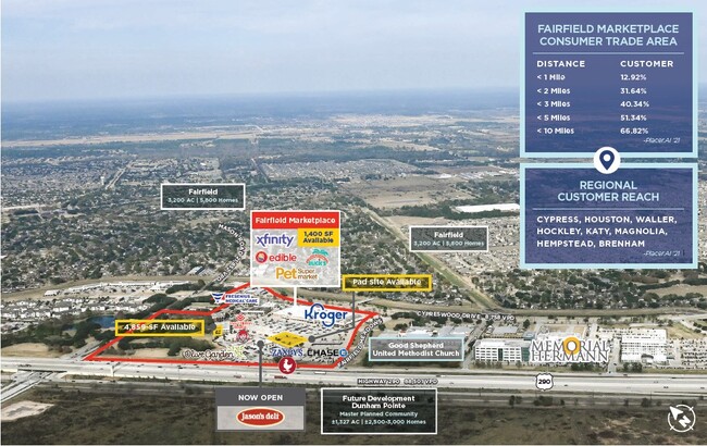
DEMOGRAPHICS near 28030 Highway 290
1 mile
3 mile
5 mile
2025 Total Population
10,248
57,453
128,763
2030 Population
10,918
61,412
139,328
Pop Growth 2025-2030
+ 6.54%
+ 6.89%
+ 8.20%
Average Age
36
36
36
2025 Total Households
3,245
17,757
40,154
HH Growth 2025-2030
+ 6.72%
+ 7.03%
+ 8.35%
Median Household Inc
$121,494
$139,174
$134,356
Avg Household Size
3.20
3.20
3.20
2025 Avg HH Vehicles
2.00
2.00
2.00
Median Home Value
$350,554
$386,394
$397,051
Median Year Built
2008
2008
2010
Nearby Places
Map Layers
Map Styles
 Street
 Aerial
Layers
 Traffic
 Biking
Places
Listings with unknown addresses are not visible on the map
- Restaurants
- Banks
- Shops
- Fitness
- Groceries
PUBLIC TRANSPORTATION
AIRPORT
George Bush Intcntl/Houston
Drive
Walk
Distance
George Bush Intcntl/Houston
43 min
30.2 mi
William P Hobby
Drive
Walk
Distance
William P Hobby
62 min
43.4 mi
Nearby Properties
Address
Land Use
TOTAL SIZE
Lot Size
Zoning
Address
Land Use
TOTAL SIZE
Lot Size
Zoning
621,523 SF
66.99 AC
Address
Land Use
TOTAL SIZE
Lot Size
Zoning
270,794 SF
30.38 AC
Address
Land Use
TOTAL SIZE
Lot Size
Zoning
443,219 SF
24.05 AC
Address
Land Use
TOTAL SIZE
Lot Size
Zoning
297,044 SF
15 AC
Address
Land Use
TOTAL SIZE
Lot Size
Zoning
321,055 SF
13.58 AC
Address
Land Use
TOTAL SIZE
Lot Size
Zoning
300,268 SF
14.85 AC
Address
Land Use
TOTAL SIZE
Lot Size
Zoning
277,343 SF
12.79 AC
Address
Land Use
TOTAL SIZE
Lot Size
Zoning
290,379 SF
17.81 AC
Address
Land Use
TOTAL SIZE
Lot Size
Zoning
172,309 SF
Address
Land Use
TOTAL SIZE
Lot Size
Zoning
237,172 SF
35.93 AC
Address
Land Use
TOTAL SIZE
Lot Size
Zoning
235,555 SF
9.74 AC
Address
Land Use
TOTAL SIZE
Lot Size
Zoning
146,694 SF
6.45 AC
Address
Land Use
TOTAL SIZE
Lot Size
Zoning
119,152 SF
12.56 AC
Address
Land Use
TOTAL SIZE
Lot Size
Zoning
266,820 SF
4.46 AC
Address
Land Use
TOTAL SIZE
Lot Size
Zoning
119,810 SF
14.25 AC
Address
Land Use
TOTAL SIZE
Lot Size
Zoning
154,676 SF
17.13 AC
Address
Land Use
TOTAL SIZE
Lot Size
Zoning
81,933 SF
9.38 AC
Address
Land Use
TOTAL SIZE
Lot Size
Zoning
267,645 SF
14.20 AC
Address
Land Use
TOTAL SIZE
Lot Size
Zoning
209,305 SF
21.77 AC
Address
Land Use
TOTAL SIZE
Lot Size
Zoning
1,207.31 AC
Address
Land Use
TOTAL SIZE
Lot Size
Zoning
116,800 SF
9.99 AC
Address
Land Use
TOTAL SIZE
Lot Size
Zoning
159,182 SF
5.96 AC
Address
Land Use
TOTAL SIZE
Lot Size
Zoning
61,242 SF
30 AC
Address
Land Use
TOTAL SIZE
Lot Size
Zoning
108.28 AC
Address
Land Use
TOTAL SIZE
Lot Size
Zoning
24,111 SF
2.11 AC
Address
Land Use
TOTAL SIZE
Lot Size
Zoning
122,276 SF
11.53 AC
Address
Land Use
TOTAL SIZE
Lot Size
Zoning
137,533 SF
14.63 AC
Address
Land Use
TOTAL SIZE
Lot Size
Zoning
698.98 AC
Address
Land Use
TOTAL SIZE
Lot Size
Zoning
75,900 SF
2.95 AC
Address
Land Use
TOTAL SIZE
Lot Size
Zoning
40,058 SF
3.69 AC
The World's #1 Commercial Real Estate Marketplace
Connect with us
© 2026 CoStar Group
The information above has been obtained from sources believed reliable. While we do not doubt its accuracy we have not verified it and make no guarantee, warranty or representation about it. It is your responsibility to independently confirm its accuracy and completeness. Any projections, opinions, assumptions, or estimates used are for example only and do not represent the current or future performance of the property. The value of this transaction to you depends on tax and other factors which should be evaluated by your tax, financial, and legal advisors. You and your advisors should conduct a careful, independent investigation of the property to determine to your satisfaction the suitability of the property for your needs.