Property Record
2804 Main St, Union Gap, WA 98903
NEARBY LISTINGS FOR SALE OR LEASE
Property Detail
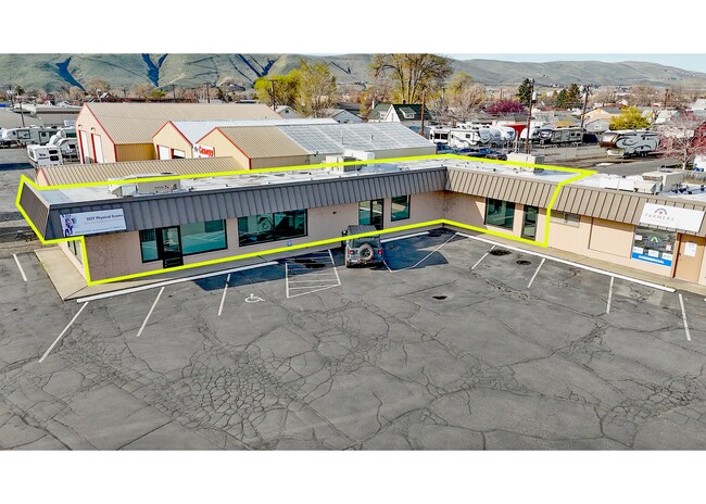
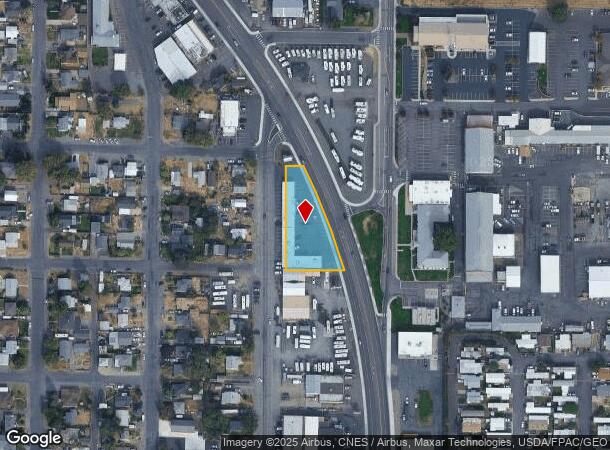
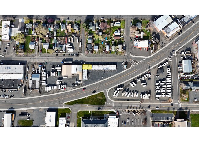
2804 Main St
191205-23405
Laubers Add.To Union Gap
Storebuilding
LAUBERS ADD.TO UNION GAP TH PT LY W OF ST.HIWAY,ALSO PT OF VAC OAK ST.ADJ.
X
Yakima
53077C1061F
Washington
2025
0.72 AC
2025
Union Gap
001400
Yakima
7,280 SF
Yakima, WA
DEMOGRAPHICS near 2804 Main St
1 Mile
3 Mile
5 Mile
2024 Total Population
3,250
34,080
92,474
2029 Population
3,239
34,129
92,697
Pop Growth 2024-2029
(0.34%)
+ 0.14%
+ 0.24%
Average Age
35
34
35
2024 Total Households
1,072
11,067
32,082
HH Growth 2024-2029
(0.47%)
+ 0.10%
+ 0.19%
Median Household Inc
$57,065
$44,319
$51,742
Avg Household Size
3.00
2.90
2.70
2024 Avg HH Vehicles
2.00
2.00
2.00
Median Home Value
$200,922
$162,928
$224,764
Median Year Built
1970
1969
1969
Nearby Places
Map Layers
Map Styles
 Street
 Aerial
- Restaurants
- Banks
- Shops
- Fitness
- Groceries
PUBLIC TRANSPORTATION
AIRPORT
Yakima Air Trml/McAllister Field
DRIVE
WALK
Distance
Yakima Air Trml/McAllister Field
8 min
3.6 mi
Freight Ports
Port of Tacoma
DRIVE
WALK
Distance
Port of Tacoma
186 min
158.9 mi
SALE & LEASE HISTORY
LISTING DATE
SALE/LEASE

May 08, 2017
For Lease
Mar 15, 2023
For Lease
Apr 09, 2025
For Lease
Nearby Properties
Address
Land Use
TOTAL SIZE
Lot Size
Zoning
Address
Land Use
TOTAL SIZE
Lot Size
Zoning
347,665 SF
37.77 AC
B2
Address
Land Use
TOTAL SIZE
Lot Size
Zoning
208,322 SF
3.69 AC
PUB
Address
Land Use
TOTAL SIZE
Lot Size
Zoning
106,878 SF
3.46 AC
RD
Address
Land Use
TOTAL SIZE
Lot Size
Zoning
129,042 SF
6.53 AC
R3
Address
Land Use
TOTAL SIZE
Lot Size
Zoning
82,436 SF
11 AC
RD
Address
Land Use
TOTAL SIZE
Lot Size
Zoning
121,488 SF
5.97 AC
R3
Address
Land Use
TOTAL SIZE
Lot Size
Zoning
345,698 SF
3.52 AC
C1
Address
Land Use
TOTAL SIZE
Lot Size
Zoning
100,992 SF
9.15 AC
RD
Address
Land Use
TOTAL SIZE
Lot Size
Zoning
91,856 SF
9.17 AC
RD
Address
Land Use
TOTAL SIZE
Lot Size
Zoning
57,009 SF
212.58 AC
AS
Address
Land Use
TOTAL SIZE
Lot Size
Zoning
97,056 SF
5.80 AC
R3
Address
Land Use
TOTAL SIZE
Lot Size
Zoning
64,171 SF
48.08 AC
PUB
Address
Land Use
TOTAL SIZE
Lot Size
Zoning
197,263 SF
18.08 AC
C1
Address
Land Use
TOTAL SIZE
Lot Size
Zoning
128,789 SF
6.65 AC
R3
Address
Land Use
TOTAL SIZE
Lot Size
Zoning
135,634 SF
9.84 AC
C1
Address
Land Use
TOTAL SIZE
Lot Size
Zoning
84,714 SF
4.40 AC
R3
Address
Land Use
TOTAL SIZE
Lot Size
Zoning
325,959 SF
11.95 AC
M2
Address
Land Use
TOTAL SIZE
Lot Size
Zoning
83,856 SF
4.23 AC
R3
Address
Land Use
TOTAL SIZE
Lot Size
Zoning
80,374 SF
8.99 AC
C1
Address
Land Use
TOTAL SIZE
Lot Size
Zoning
114,406 SF
15.50 AC
PUB
Address
Land Use
TOTAL SIZE
Lot Size
Zoning
151,831 SF
21.08 AC
M1
Address
Land Use
TOTAL SIZE
Lot Size
Zoning
43,687 SF
3.33 AC
C1
Address
Land Use
TOTAL SIZE
Lot Size
Zoning
195,753 SF
11.66 AC
M1
Address
Land Use
TOTAL SIZE
Lot Size
Zoning
82,422 SF
4.58 AC
C1
Address
Land Use
TOTAL SIZE
Lot Size
Zoning
38,498 SF
7 AC
C1
Address
Land Use
TOTAL SIZE
Lot Size
Zoning
76,160 SF
39.51 AC
M1
Address
Land Use
TOTAL SIZE
Lot Size
Zoning
69.87 AC
SR
Address
Land Use
TOTAL SIZE
Lot Size
Zoning
123,690 SF
12.02 AC
M1
Address
Land Use
TOTAL SIZE
Lot Size
Zoning
204,600 SF
12.54 AC
B2
Address
Land Use
TOTAL SIZE
Lot Size
Zoning
9,121 SF
0.22 AC
C1
The World's #1 Commercial Real Estate Marketplace
Connect with us
© 2025 CoStar Group
The information above has been obtained from sources believed reliable. While we do not doubt its accuracy we have not verified it and make no guarantee, warranty or representation about it. It is your responsibility to independently confirm its accuracy and completeness. Any projections, opinions, assumptions, or estimates used are for example only and do not represent the current or future performance of the property. The value of this transaction to you depends on tax and other factors which should be evaluated by your tax, financial, and legal advisors. You and your advisors should conduct a careful, independent investigation of the property to determine to your satisfaction the suitability of the property for your needs.