Property Record
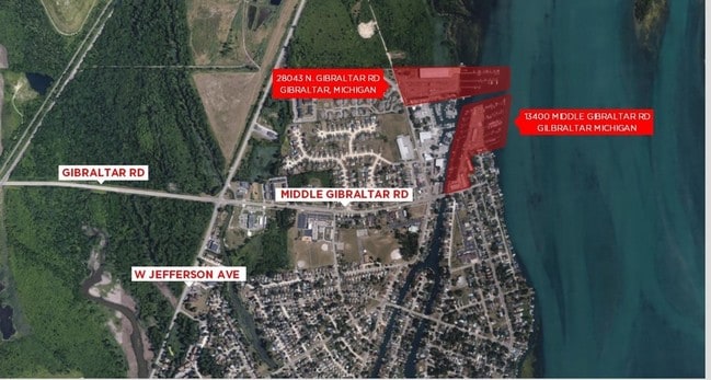
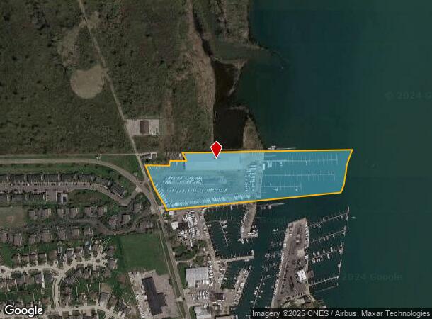
28043 N Gibraltar Rd, Gibraltar, MI 48173
NEARBY LISTINGS FOR SALE OR LEASE
Property Detail
28043 N Gibraltar Rd
36-010-99-0001-700
36D2C1 T4S PART OF FRAC SEC 36 T4S R10E DESC AS BEG AT A PT ON THE E'LY LINE OF N. GIBRALTAR ROAD WHICH IS DIST N 89D 09M 10S E 35.06 FT AND S 20D 34M 10S E 100 FT FROM INTERSECTION OF THE S LINE OF PC 345 AND THE CENTERLINE OF N GIBRALTAR RD; TH S 2
Commercialnec
Wayne
AE
Michigan
26163C0527F
0001
2025
15.10 AC
2025
Downriver South
597000
Detroit
66,279 SF
Detroit-Warren-Dearborn, MI
DEMOGRAPHICS near 28043 N Gibraltar Rd
1 Mile
3 Mile
5 Mile
2024 Total Population
3,027
28,961
75,286
2029 Population
2,913
27,730
72,340
Pop Growth 2024-2029
(3.77%)
(4.25%)
(3.91%)
Average Age
43
43
43
2024 Total Households
1,300
12,042
31,104
HH Growth 2024-2029
(3.85%)
(4.30%)
(3.94%)
Median Household Inc
$89,705
$83,146
$80,475
Avg Household Size
2.30
2.40
2.40
2024 Avg HH Vehicles
2.00
2.00
2.00
Median Home Value
$239,458
$212,126
$218,788
Median Year Built
1972
1973
1974
Nearby Places
Map Layers
Map Styles
 Street
 Aerial
- Restaurants
- Banks
- Shops
- Fitness
- Groceries
PUBLIC TRANSPORTATION
AIRPORT
Detroit Metro Wayne County
DRIVE
WALK
Distance
Detroit Metro Wayne County
32 min
18.8 mi
Windsor International
DRIVE
WALK
Distance
Windsor International
52 min
33.1 mi
Freight Ports
DRIVE
WALK
Distance
55 min
41.7 mi
Nearby Properties
Address
Land Use
TOTAL SIZE
Lot Size
Zoning
Address
Land Use
TOTAL SIZE
Lot Size
Zoning
3,189,689 SF
228.88 AC
Address
Land Use
TOTAL SIZE
Lot Size
Zoning
2,651,867 SF
137.23 AC
I-3
Address
Land Use
TOTAL SIZE
Lot Size
Zoning
155,600 SF
83.84 AC
R1
Address
Land Use
TOTAL SIZE
Lot Size
Zoning
235,489 SF
23.47 AC
Address
Land Use
TOTAL SIZE
Lot Size
Zoning
150,224 SF
15.45 AC
RM-1
Address
Land Use
TOTAL SIZE
Lot Size
Zoning
1,021,918 SF
163.58 AC
Address
Land Use
TOTAL SIZE
Lot Size
Zoning
178,682 SF
19.23 AC
Address
Land Use
TOTAL SIZE
Lot Size
Zoning
92,397 SF
12.63 AC
PUD
Address
Land Use
TOTAL SIZE
Lot Size
Zoning
169,192 SF
11.90 AC
R1
Address
Land Use
TOTAL SIZE
Lot Size
Zoning
59,427 SF
5.50 AC
Address
Land Use
TOTAL SIZE
Lot Size
Zoning
68,409 SF
64.56 AC
Address
Land Use
TOTAL SIZE
Lot Size
Zoning
2,368 SF
32.58 AC
Address
Land Use
TOTAL SIZE
Lot Size
Zoning
95,650 SF
73.78 AC
Address
Land Use
TOTAL SIZE
Lot Size
Zoning
48,760 SF
4.86 AC
Address
Land Use
TOTAL SIZE
Lot Size
Zoning
18,678 SF
3.10 AC
R1-ONE
Address
Land Use
TOTAL SIZE
Lot Size
Zoning
2,816 SF
86.70 AC
RESIDE
Address
Land Use
TOTAL SIZE
Lot Size
Zoning
146,300 SF
25.84 AC
Address
Land Use
TOTAL SIZE
Lot Size
Zoning
101,861 SF
15.33 AC
B-2
Address
Land Use
TOTAL SIZE
Lot Size
Zoning
62,039 SF
Address
Land Use
TOTAL SIZE
Lot Size
Zoning
44,733 SF
10.51 AC
Address
Land Use
TOTAL SIZE
Lot Size
Zoning
164,567 SF
13.78 AC
RESIDE
Address
Land Use
TOTAL SIZE
Lot Size
Zoning
60 SF
3.83 AC
PCA
Address
Land Use
TOTAL SIZE
Lot Size
Zoning
551,184 SF
RESIDE
Address
Land Use
TOTAL SIZE
Lot Size
Zoning
124,602 SF
10.20 AC
Address
Land Use
TOTAL SIZE
Lot Size
Zoning
52,085 SF
5 AC
RM-1
Address
Land Use
TOTAL SIZE
Lot Size
Zoning
551,184 SF
42.34 AC
RESIDE
Address
Land Use
TOTAL SIZE
Lot Size
Zoning
16.38 AC
OR-1
Address
Land Use
TOTAL SIZE
Lot Size
Zoning
40,136 SF
42.97 AC
R-1-D
Address
Land Use
TOTAL SIZE
Lot Size
Zoning
76,221 SF
25.86 AC
Address
Land Use
TOTAL SIZE
Lot Size
Zoning
92.87 AC
The World's #1 Commercial Real Estate Marketplace
Connect with us
© 2025 CoStar Group
The information above has been obtained from sources believed reliable. While we do not doubt its accuracy we have not verified it and make no guarantee, warranty or representation about it. It is your responsibility to independently confirm its accuracy and completeness. Any projections, opinions, assumptions, or estimates used are for example only and do not represent the current or future performance of the property. The value of this transaction to you depends on tax and other factors which should be evaluated by your tax, financial, and legal advisors. You and your advisors should conduct a careful, independent investigation of the property to determine to your satisfaction the suitability of the property for your needs.