Property Record
28044 Se Highway 212, Boring, OR 97009
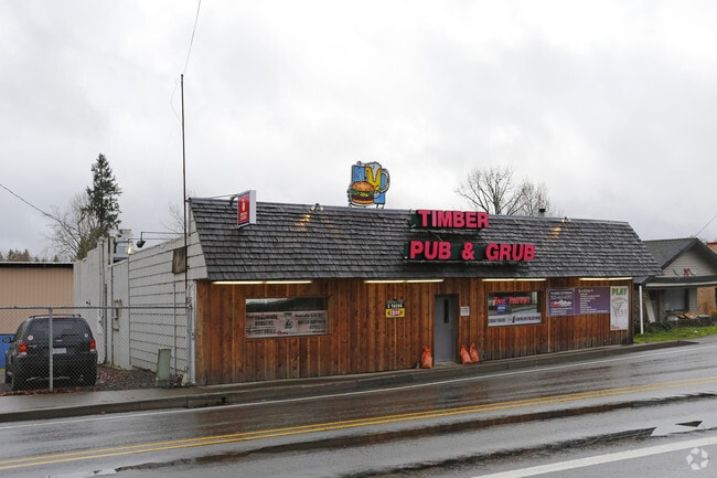

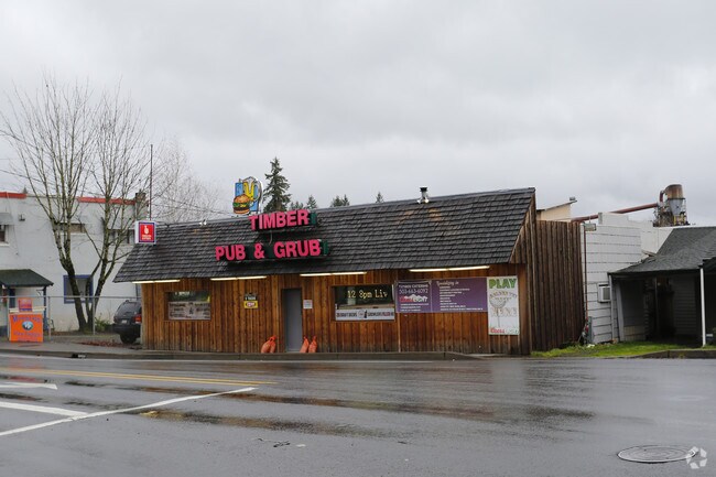

Property Detail
28044 Se Highway 212
00599089
143 BORING JUNCTION PT BLK 4
Commercialbuilding
CLACKAMAS
RC
Oregon
B and X Area of moderate flood hazard, usually the area between the limits of the 100-year and 500-year floods.
0.14 AC
2025
SE Outlying
2025
Portland
023300
Portland-Vancouver-Hillsboro, OR-WA
3,080 SF
NEARBY LISTINGS FOR SALE OR LEASE
DEMOGRAPHICS near 28044 Se Highway 212
1 mile
3 mile
5 mile
2025 Total Population
1,740
8,858
50,361
2030 Population
1,721
8,765
49,851
Pop Growth 2025-2030
(1.09%)
(1.05%)
(1.01%)
Average Age
45
45
42
2025 Total Households
608
3,047
17,140
HH Growth 2025-2030
(1.15%)
(1.21%)
(1.28%)
Median Household Inc
$124,166
$122,090
$100,632
Avg Household Size
2.80
2.80
2.80
2025 Avg HH Vehicles
3.00
3.00
3.00
Median Home Value
$721,186
$720,030
$603,324
Median Year Built
1975
1976
1985
Nearby Places
Map Layers
Map Styles
 Street
 Aerial
Transit
 Traffic
 Biking
Places
Listings with unknown addresses are not visible on the map
- Restaurants
- Banks
- Shops
- Fitness
- Groceries
PUBLIC TRANSPORTATION
AIRPORT
Portland International
Drive
Walk
Distance
Portland International
34 min
19.9 mi
Freight Ports
Port of Portland
Drive
Walk
Distance
Port of Portland
40 min
23.7 mi
Nearby Properties
Address
Land Use
TOTAL SIZE
Lot Size
Zoning
Address
Land Use
TOTAL SIZE
Lot Size
Zoning
102,431 SF
11.56 AC
RC
Address
Land Use
TOTAL SIZE
Lot Size
Zoning
7.80 AC
FF10
Address
Land Use
TOTAL SIZE
Lot Size
Zoning
1,015 SF
7.45 AC
FF10
Address
Land Use
TOTAL SIZE
Lot Size
Zoning
Address
Land Use
TOTAL SIZE
Lot Size
Zoning
5.62 AC
RI
Address
Land Use
TOTAL SIZE
Lot Size
Zoning
5,376 SF
9.60 AC
RRFF5
Address
Land Use
TOTAL SIZE
Lot Size
Zoning
3,176 SF
4 AC
RA1
Address
Land Use
TOTAL SIZE
Lot Size
Zoning
9.21 AC
RI
Address
Land Use
TOTAL SIZE
Lot Size
Zoning
9,345 SF
4.94 AC
MUA20
Address
Land Use
TOTAL SIZE
Lot Size
Zoning
4.23 AC
RI
Address
Land Use
TOTAL SIZE
Lot Size
Zoning
1,228 SF
2.75 AC
RI
Address
Land Use
TOTAL SIZE
Lot Size
Zoning
3.56 AC
RC
Address
Land Use
TOTAL SIZE
Lot Size
Zoning
400 SF
0.75 AC
RC
Address
Land Use
TOTAL SIZE
Lot Size
Zoning
8,000 SF
2 AC
RC
Address
Land Use
TOTAL SIZE
Lot Size
Zoning
2,300 SF
3.10 AC
RRFF5
Address
Land Use
TOTAL SIZE
Lot Size
Zoning
32,010 SF
2.53 AC
RC
Address
Land Use
TOTAL SIZE
Lot Size
Zoning
1,882 SF
9.55 AC
FF10
Address
Land Use
TOTAL SIZE
Lot Size
Zoning
1 AC
RC
Address
Land Use
TOTAL SIZE
Lot Size
Zoning
1.29 AC
RC
Address
Land Use
TOTAL SIZE
Lot Size
Zoning
1.79 AC
RI
Address
Land Use
TOTAL SIZE
Lot Size
Zoning
3,039 SF
13.68 AC
RI
Address
Land Use
TOTAL SIZE
Lot Size
Zoning
0.64 AC
RI
Address
Land Use
TOTAL SIZE
Lot Size
Zoning
5,760 SF
8.12 AC
RRFF5
Address
Land Use
TOTAL SIZE
Lot Size
Zoning
8.55 AC
RRFF5
Address
Land Use
TOTAL SIZE
Lot Size
Zoning
1.45 AC
RI
Address
Land Use
TOTAL SIZE
Lot Size
Zoning
3,162 SF
0.94 AC
RC
Address
Land Use
TOTAL SIZE
Lot Size
Zoning
2,216 SF
1.63 AC
RC
Address
Land Use
TOTAL SIZE
Lot Size
Zoning
3.45 AC
RI
Address
Land Use
TOTAL SIZE
Lot Size
Zoning
8,718 SF
34.33 AC
EFU
The World's #1 Commercial Real Estate Marketplace
Connect with us
© 2026 CoStar Group
The information above has been obtained from sources believed reliable. While we do not doubt its accuracy we have not verified it and make no guarantee, warranty or representation about it. It is your responsibility to independently confirm its accuracy and completeness. Any projections, opinions, assumptions, or estimates used are for example only and do not represent the current or future performance of the property. The value of this transaction to you depends on tax and other factors which should be evaluated by your tax, financial, and legal advisors. You and your advisors should conduct a careful, independent investigation of the property to determine to your satisfaction the suitability of the property for your needs.