Property Record
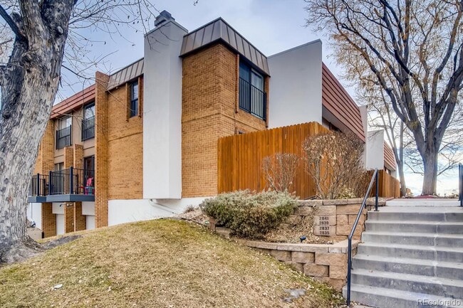
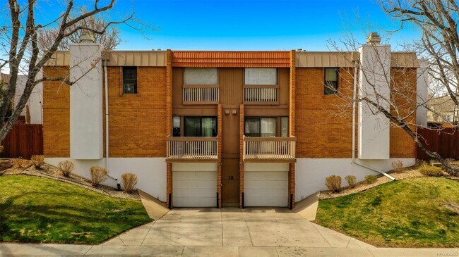
2879 S Locust St, Denver, CO 80222
This Property Is For Sale
NEARBY LISTINGS FOR SALE OR LEASE
Property Detail
2879 S Locust St
Denver-Aurora-Lakewood, CO
Plaza Iii Condos U-F B
6322-02-060
Denver
Condominium
Colorado
X
0.04 AC
0800460216H
Hampden
1,428 SF
Denver
DEMOGRAPHICS near 2879 S Locust St
1 Mile
3 Mile
5 Mile
2024 Total Population
19,361
165,975
399,823
2029 Population
19,448
168,194
404,240
Pop Growth 2024-2029
+ 0.45%
+ 1.34%
+ 1.10%
Average Age
42
39
40
2024 Total Households
8,910
77,406
183,564
HH Growth 2024-2029
+ 0.31%
+ 1.31%
+ 1.10%
Median Household Inc
$79,799
$73,501
$80,102
Avg Household Size
2.10
2.10
2.10
2024 Avg HH Vehicles
2.00
2.00
2.00
Median Home Value
$596,483
$593,966
$632,217
Median Year Built
1971
1978
1977
Nearby Places
- Restaurants
- Banks
- Shops
- Fitness
- Groceries
PUBLIC TRANSPORTATION
TRANSIT/SUBWAY
Yale (E Line - Denver Regional Transportation District Light Rail (TheRide), F Line - Denver Regional Transportation District Light Rail (TheRide), H Line - Denver Regional Transportation District Light Rail (TheRide))
DRIVE
WALK
Distance
Yale (E Line - Denver Regional Transportation District Light Rail (TheRide), F Line - Denver Regional Transportation District Light Rail (TheRide), H Line - Denver Regional Transportation District Light Rail (TheRide))
5 min
18 min
0.9 mi
COMMUTER RAIL
Central Park Station Track 1 (Union Station to Denver Airport Station - Regional Transportation District)
DRIVE
WALK
Distance
Central Park Station Track 1 (Union Station to Denver Airport Station - Regional Transportation District)
20 min
9.0 mi
Central Park Station Track 2 (Union Station to Denver Airport Station - Regional Transportation District)
DRIVE
WALK
Distance
Central Park Station Track 2 (Union Station to Denver Airport Station - Regional Transportation District)
20 min
9.1 mi
AIRPORT
Denver International
DRIVE
WALK
Distance
Denver International
36 min
28.2 mi
Freight Ports
Tulsa Port Of Catoosa
DRIVE
WALK
Distance
Tulsa Port Of Catoosa
732 min
710.9 mi
Nearby Properties
Address
Land Use
TOTAL SIZE
Lot Size
Zoning
Address
Land Use
TOTAL SIZE
Lot Size
Zoning
1,137,044 SF
35.49 AC
CMP-EI
Address
Land Use
TOTAL SIZE
Lot Size
Zoning
389,502 SF
2.32 AC
T-MU-30
Address
Land Use
TOTAL SIZE
Lot Size
Zoning
550,760 SF
13.25 AC
CMP-EI
Address
Land Use
TOTAL SIZE
Lot Size
Zoning
331,620 SF
2.03 AC
T-MU-30
Address
Land Use
TOTAL SIZE
Lot Size
Zoning
543,122 SF
13.43 AC
CMP-EI
Address
Land Use
TOTAL SIZE
Lot Size
Zoning
470,605 SF
13.68 AC
B-8
Address
Land Use
TOTAL SIZE
Lot Size
Zoning
898,130 SF
89.50 AC
Address
Land Use
TOTAL SIZE
Lot Size
Zoning
416,096 SF
5.20 AC
C-MX-20
Address
Land Use
TOTAL SIZE
Lot Size
Zoning
240,545 SF
2.35 AC
C-MX-20
Address
Land Use
TOTAL SIZE
Lot Size
Zoning
281,456 SF
36.55 AC
R-5
Address
Land Use
TOTAL SIZE
Lot Size
Zoning
249,331 SF
4.93 AC
B-8
Address
Land Use
TOTAL SIZE
Lot Size
Zoning
174,244 SF
17.26 AC
E-SU-DX
Address
Land Use
TOTAL SIZE
Lot Size
Zoning
191,152 SF
1.26 AC
S-MX-12
Address
Land Use
TOTAL SIZE
Lot Size
Zoning
359,561 SF
2.28 AC
B-8
Address
Land Use
TOTAL SIZE
Lot Size
Zoning
1,054,198 SF
6.62 AC
PUD
Address
Land Use
TOTAL SIZE
Lot Size
Zoning
379,927 SF
8.06 AC
PUD
Address
Land Use
TOTAL SIZE
Lot Size
Zoning
129,234 SF
0.95 AC
T-MU-30
Address
Land Use
TOTAL SIZE
Lot Size
Zoning
313,836 SF
5.90 AC
B-8
Address
Land Use
TOTAL SIZE
Lot Size
Zoning
372,593 SF
5.61 AC
S-MX-12
Address
Land Use
TOTAL SIZE
Lot Size
Zoning
14,878 SF
34.55 AC
OS-B
Address
Land Use
TOTAL SIZE
Lot Size
Zoning
320,589 SF
33.33 AC
S-SU-F
Address
Land Use
TOTAL SIZE
Lot Size
Zoning
396,041 SF
6.77 AC
B-8
Address
Land Use
TOTAL SIZE
Lot Size
Zoning
124,658 SF
2.13 AC
CMP-EI
Address
Land Use
TOTAL SIZE
Lot Size
Zoning
355,464 SF
6.20 AC
B-8
Address
Land Use
TOTAL SIZE
Lot Size
Zoning
231,867 SF
19.33 AC
S-MX-3A
Address
Land Use
TOTAL SIZE
Lot Size
Zoning
613,600 SF
29.40 AC
R-3
Address
Land Use
TOTAL SIZE
Lot Size
Zoning
158,805 SF
3.71 AC
CMP-EI
Address
Land Use
TOTAL SIZE
Lot Size
Zoning
193,299 SF
2.90 AC
S-MX-12
Address
Land Use
TOTAL SIZE
Lot Size
Zoning
479,448 SF
5.37 AC
Address
Land Use
TOTAL SIZE
Lot Size
Zoning
441,456 SF
21.82 AC
B-4
The World's #1 Commercial Real Estate Marketplace
Connect with us
© 2025 CoStar Group
The information above has been obtained from sources believed reliable. While we do not doubt its accuracy we have not verified it and make no guarantee, warranty or representation about it. It is your responsibility to independently confirm its accuracy and completeness. Any projections, opinions, assumptions, or estimates used are for example only and do not represent the current or future performance of the property. The value of this transaction to you depends on tax and other factors which should be evaluated by your tax, financial, and legal advisors. You and your advisors should conduct a careful, independent investigation of the property to determine to your satisfaction the suitability of the property for your needs.