Property Record
2805 Earls Bridge Rd, Easley, SC 29640
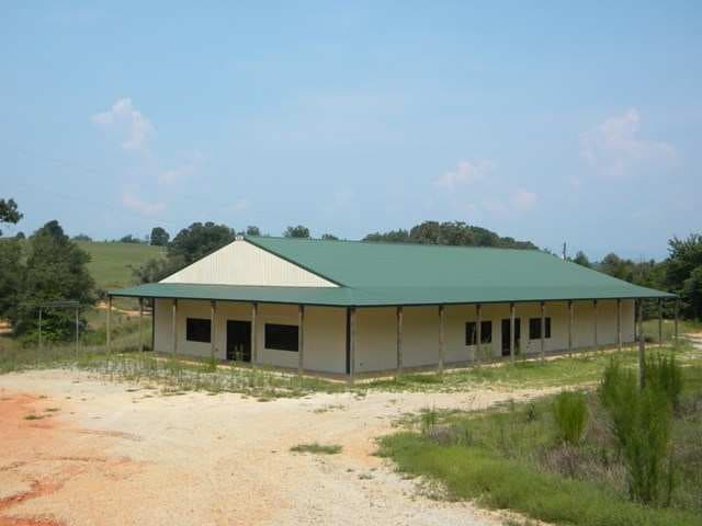

Property Detail
2805 Earls Bridge Rd
5133-03-44-2005
NW/SIDE EARLS BRIDGE RD PLAT 599/242 PLAT 275/3 PLAT 35/185 PLAT 213/8A, PLAT 599/241 TRACT C,
Warehouse
Pickens
B and X Area of moderate flood hazard, usually the area between the limits of the 100-year and 500-year floods.
South Carolina
2025
1 AC
2025
Outlying Pickens Co
010601
Greenville/Spartanburg
5,000 SF
Greenville-Anderson-Greer, SC
NEARBY LISTINGS FOR SALE OR LEASE
-
-
View all Easley listings for sale on LoopNet.com
DEMOGRAPHICS near 2805 Earls Bridge Rd
1 mile
3 mile
5 mile
2025 Total Population
709
4,158
12,934
2030 Population
755
4,413
13,788
Pop Growth 2025-2030
+ 6.49%
+ 6.13%
+ 6.60%
Average Age
43
43
42
2025 Total Households
275
1,613
4,967
HH Growth 2025-2030
+ 6.91%
+ 6.51%
+ 6.89%
Median Household Inc
$54,166
$52,931
$58,677
Avg Household Size
2.50
2.60
2.50
2025 Avg HH Vehicles
2.00
2.00
2.00
Median Home Value
$220,149
$217,847
$246,788
Median Year Built
1996
1993
1992
Nearby Places
Map Layers
Map Styles
 Street
 Aerial
Layers
 Traffic
 Biking
Places
Listings with unknown addresses are not visible on the map
- Restaurants
- Banks
- Shops
- Fitness
- Groceries
PUBLIC TRANSPORTATION
AIRPORT
Greenville Spartanburg International
Drive
Walk
Distance
Greenville Spartanburg International
45 min
27.4 mi
Asheville Regional
Drive
Walk
Distance
Asheville Regional
66 min
46.5 mi
Nearby Properties
Address
Land Use
TOTAL SIZE
Lot Size
Zoning
Address
Land Use
TOTAL SIZE
Lot Size
Zoning
225.50 AC
RS
Address
Land Use
TOTAL SIZE
Lot Size
Zoning
7,919 SF
2.93 AC
Address
Land Use
TOTAL SIZE
Lot Size
Zoning
3,238 SF
2.86 AC
Address
Land Use
TOTAL SIZE
Lot Size
Zoning
113.65 AC
Address
Land Use
TOTAL SIZE
Lot Size
Zoning
768 SF
37.41 AC
Address
Land Use
TOTAL SIZE
Lot Size
Zoning
4,160 SF
0.30 AC
Address
Land Use
TOTAL SIZE
Lot Size
Zoning
750 SF
2.86 AC
Address
Land Use
TOTAL SIZE
Lot Size
Zoning
10.15 AC
Address
Land Use
TOTAL SIZE
Lot Size
Zoning
1,550 SF
0.99 AC
Address
Land Use
TOTAL SIZE
Lot Size
Zoning
2,760 SF
102 AC
Address
Land Use
TOTAL SIZE
Lot Size
Zoning
4 AC
RS
Address
Land Use
TOTAL SIZE
Lot Size
Zoning
9,177 SF
4.44 AC
Address
Land Use
TOTAL SIZE
Lot Size
Zoning
4,000 SF
1.02 AC
Address
Land Use
TOTAL SIZE
Lot Size
Zoning
4,444 SF
1.79 AC
Address
Land Use
TOTAL SIZE
Lot Size
Zoning
Address
Land Use
TOTAL SIZE
Lot Size
Zoning
Address
Land Use
TOTAL SIZE
Lot Size
Zoning
3,250 SF
15.08 AC
Address
Land Use
TOTAL SIZE
Lot Size
Zoning
50.48 AC
Address
Land Use
TOTAL SIZE
Lot Size
Zoning
Address
Land Use
TOTAL SIZE
Lot Size
Zoning
66.10 AC
Address
Land Use
TOTAL SIZE
Lot Size
Zoning
2,146 SF
0.78 AC
Address
Land Use
TOTAL SIZE
Lot Size
Zoning
2,685 SF
22.98 AC
Address
Land Use
TOTAL SIZE
Lot Size
Zoning
6.28 AC
Address
Land Use
TOTAL SIZE
Lot Size
Zoning
2,956 SF
5.15 AC
Address
Land Use
TOTAL SIZE
Lot Size
Zoning
1.68 AC
Address
Land Use
TOTAL SIZE
Lot Size
Zoning
2,400 SF
2.87 AC
Address
Land Use
TOTAL SIZE
Lot Size
Zoning
1,613 SF
0.92 AC
Address
Land Use
TOTAL SIZE
Lot Size
Zoning
5,282 SF
1.34 AC
Address
Land Use
TOTAL SIZE
Lot Size
Zoning
4,906 SF
1 AC
Address
Land Use
TOTAL SIZE
Lot Size
Zoning
3,533 SF
15.17 AC
RS
The World's #1 Commercial Real Estate Marketplace
Connect with us
© 2026 CoStar Group
The information above has been obtained from sources believed reliable. While we do not doubt its accuracy we have not verified it and make no guarantee, warranty or representation about it. It is your responsibility to independently confirm its accuracy and completeness. Any projections, opinions, assumptions, or estimates used are for example only and do not represent the current or future performance of the property. The value of this transaction to you depends on tax and other factors which should be evaluated by your tax, financial, and legal advisors. You and your advisors should conduct a careful, independent investigation of the property to determine to your satisfaction the suitability of the property for your needs.