Property Record
2805 N 155Th Ter, Basehor, KS 66007
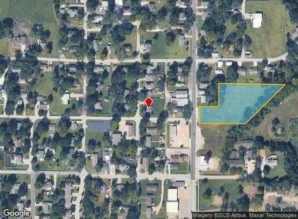

This Property Is For Sale
NEARBY LISTINGS FOR SALE OR LEASE
-
-
View all Basehor listings for sale on LoopNet.com
Property Detail
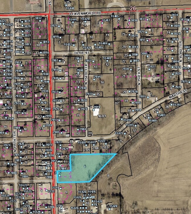
2805 N 155Th Ter
Kansas City, MO-KS
Basehor, Town Of
157-35-0-20-05-006.00-0
BASEHOR, TOWN OF, S35, T10, R22E, BLOCK 1, S3LT 5 & ALL LT 6 & 7 & ALSO PT NW1/4 NW1/4 BEG NE COR LT3 BLK1 1ST & 2ND ADD, E410(S), SW345(S), W170(S), N250 TO POB
Commercialnec
Leavenworth
X
Kansas
20209C0020E
6,7
2024
1.90 AC
2025
Leavenworth County
071204
Kansas City
DEMOGRAPHICS near 2805 N 155Th Ter
1 Mile
3 Mile
5 Mile
2024 Total Population
3,325
10,313
21,300
2029 Population
3,576
11,015
21,926
Pop Growth 2024-2029
+ 7.55%
+ 6.81%
+ 2.94%
Average Age
40
41
41
2024 Total Households
1,251
3,809
7,857
HH Growth 2024-2029
+ 7.83%
+ 7.06%
+ 3.02%
Median Household Inc
$83,561
$99,492
$107,451
Avg Household Size
2.60
2.70
2.70
2024 Avg HH Vehicles
2.00
2.00
2.00
Median Home Value
$277,175
$341,037
$350,105
Median Year Built
1994
1998
1999
Nearby Places
Map Layers
Map Styles
 Street
 Aerial
- Restaurants
- Banks
- Shops
- Fitness
- Groceries
PUBLIC TRANSPORTATION
AIRPORT
Kansas City International
DRIVE
WALK
Distance
Kansas City International
39 min
29.5 mi
Freight Ports
Tulsa Port Of Catoosa
DRIVE
WALK
Distance
Tulsa Port Of Catoosa
280 min
248.2 mi
Nearby Properties
Address
Land Use
TOTAL SIZE
Lot Size
Zoning
Address
Land Use
TOTAL SIZE
Lot Size
Zoning
169,410 SF
37.81 AC
Address
Land Use
TOTAL SIZE
Lot Size
Zoning
77,925 SF
11.31 AC
Address
Land Use
TOTAL SIZE
Lot Size
Zoning
52,047 SF
12.18 AC
Address
Land Use
TOTAL SIZE
Lot Size
Zoning
21,511 SF
5.23 AC
Address
Land Use
TOTAL SIZE
Lot Size
Zoning
27,279 SF
17.93 AC
Address
Land Use
TOTAL SIZE
Lot Size
Zoning
39,215 SF
18.35 AC
Address
Land Use
TOTAL SIZE
Lot Size
Zoning
48,590 SF
4.72 AC
Address
Land Use
TOTAL SIZE
Lot Size
Zoning
2.75 AC
Address
Land Use
TOTAL SIZE
Lot Size
Zoning
27,568 SF
6.57 AC
WR1
Address
Land Use
TOTAL SIZE
Lot Size
Zoning
19,753 SF
4.83 AC
Address
Land Use
TOTAL SIZE
Lot Size
Zoning
16,854 SF
2.60 AC
Address
Land Use
TOTAL SIZE
Lot Size
Zoning
14,834 SF
9.99 AC
Address
Land Use
TOTAL SIZE
Lot Size
Zoning
12,163 SF
3.31 AC
Address
Land Use
TOTAL SIZE
Lot Size
Zoning
9,100 SF
0.64 AC
Address
Land Use
TOTAL SIZE
Lot Size
Zoning
73.91 AC
Address
Land Use
TOTAL SIZE
Lot Size
Zoning
33,125 SF
5.20 AC
Address
Land Use
TOTAL SIZE
Lot Size
Zoning
5,262 SF
1.94 AC
Address
Land Use
TOTAL SIZE
Lot Size
Zoning
13,867 SF
3 AC
Address
Land Use
TOTAL SIZE
Lot Size
Zoning
43,170 SF
6.25 AC
Address
Land Use
TOTAL SIZE
Lot Size
Zoning
21,000 SF
5.47 AC
Address
Land Use
TOTAL SIZE
Lot Size
Zoning
26,626 SF
4.66 AC
Address
Land Use
TOTAL SIZE
Lot Size
Zoning
251,824 SF
137.79 AC
WAG
Address
Land Use
TOTAL SIZE
Lot Size
Zoning
Address
Land Use
TOTAL SIZE
Lot Size
Zoning
900 SF
12 AC
Address
Land Use
TOTAL SIZE
Lot Size
Zoning
5,600 SF
7.73 AC
Address
Land Use
TOTAL SIZE
Lot Size
Zoning
7,952 SF
1 AC
Address
Land Use
TOTAL SIZE
Lot Size
Zoning
9,300 SF
9.73 AC
Address
Land Use
TOTAL SIZE
Lot Size
Zoning
759 SF
15.03 AC
Address
Land Use
TOTAL SIZE
Lot Size
Zoning
10,500 SF
1.12 AC
Address
Land Use
TOTAL SIZE
Lot Size
Zoning
6,020 SF
0.75 AC
The World's #1 Commercial Real Estate Marketplace
Connect with us
© 2025 CoStar Group
The information above has been obtained from sources believed reliable. While we do not doubt its accuracy we have not verified it and make no guarantee, warranty or representation about it. It is your responsibility to independently confirm its accuracy and completeness. Any projections, opinions, assumptions, or estimates used are for example only and do not represent the current or future performance of the property. The value of this transaction to you depends on tax and other factors which should be evaluated by your tax, financial, and legal advisors. You and your advisors should conduct a careful, independent investigation of the property to determine to your satisfaction the suitability of the property for your needs.