Property Record
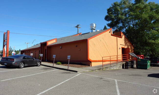
2805 Wheaton Way, Bremerton, WA 98310


Property Detail
2805 Wheaton Way
112401-1-087-2008
(LOT C CITY OF BREMERTON SHORT PLAT NO SP-8-88 RECORDED UNDER AUDITOR NO 8905220159, B-197) THAT PORTION OF THE NORTHEAST QUARTER OF THE NORTHEAST QUARTER OF SECTION 11, TOWNSHIP 24 NORTH, RANGE 1 EAST, W.M., IN KITSAP COUNTY, WASHINGTON, DESCRIBED A
Restaurantbuilding
Kitsap
GC
Washington
B and X Area of moderate flood hazard, usually the area between the limits of the 100-year and 500-year floods.
c
2025
2.72 AC
2026
East Bremerton
080102
Bremerton/Silverdale
3,040 SF
Bremerton-Silverdale-Port Orchard, WA
NEARBY LISTINGS FOR SALE OR LEASE
DEMOGRAPHICS near 2805 Wheaton Way
1 mile
3 mile
5 mile
2025 Total Population
15,413
65,928
124,110
2030 Population
15,874
67,564
127,143
Pop Growth 2025-2030
+ 2.99%
+ 2.48%
+ 2.44%
Average Age
40
39
40
2025 Total Households
6,490
25,462
47,879
HH Growth 2025-2030
+ 3.14%
+ 2.78%
+ 2.67%
Median Household Inc
$72,172
$78,233
$87,470
Avg Household Size
2.30
2.30
2.40
2025 Avg HH Vehicles
2.00
2.00
2.00
Median Home Value
$433,970
$456,178
$475,006
Median Year Built
1975
1973
1979
Nearby Places
Map Layers
Map Styles
 Street
 Aerial
Layers
 Traffic
 Biking
Places
Listings with unknown addresses are not visible on the map
- Restaurants
- Banks
- Shops
- Fitness
- Groceries
PUBLIC TRANSPORTATION
AIRPORT
Seattle Paine Field International
Drive
Walk
Distance
Seattle Paine Field International
90 min
40.8 mi
Nearby Properties
Address
Land Use
TOTAL SIZE
Lot Size
Zoning
Address
Land Use
TOTAL SIZE
Lot Size
Zoning
329,553 SF
18.89 AC
UM
Address
Land Use
TOTAL SIZE
Lot Size
Zoning
0.13 AC
UH
Address
Land Use
TOTAL SIZE
Lot Size
Zoning
21,408 SF
8.26 AC
BVSAP
Address
Land Use
TOTAL SIZE
Lot Size
Zoning
134,724 SF
6.85 AC
GC
Address
Land Use
TOTAL SIZE
Lot Size
Zoning
151,599 SF
5.44 AC
R-40
Address
Land Use
TOTAL SIZE
Lot Size
Zoning
2,672 SF
0.13 AC
UHUL
Address
Land Use
TOTAL SIZE
Lot Size
Zoning
214,450 SF
21.68 AC
R-40
Address
Land Use
TOTAL SIZE
Lot Size
Zoning
192,475 SF
16.26 AC
C
Address
Land Use
TOTAL SIZE
Lot Size
Zoning
1,716 SF
3.70 AC
UH
Address
Land Use
TOTAL SIZE
Lot Size
Zoning
Address
Land Use
TOTAL SIZE
Lot Size
Zoning
80,228 SF
7.03 AC
GC
Address
Land Use
TOTAL SIZE
Lot Size
Zoning
1,344 SF
5.47 AC
R-40
Address
Land Use
TOTAL SIZE
Lot Size
Zoning
79,615 SF
1.25 AC
DSAP
Address
Land Use
TOTAL SIZE
Lot Size
Zoning
75,390 SF
4.46 AC
R-18
Address
Land Use
TOTAL SIZE
Lot Size
Zoning
122,799 SF
4.48 AC
R-40
Address
Land Use
TOTAL SIZE
Lot Size
Zoning
63,213 SF
4.15 AC
R-10
Address
Land Use
TOTAL SIZE
Lot Size
Zoning
150,790 SF
26.33 AC
C
Address
Land Use
TOTAL SIZE
Lot Size
Zoning
58,376 SF
6.68 AC
R-18
Address
Land Use
TOTAL SIZE
Lot Size
Zoning
64,584 SF
4.92 AC
R-40
Address
Land Use
TOTAL SIZE
Lot Size
Zoning
68,079 SF
2.16 AC
BVSAP
Address
Land Use
TOTAL SIZE
Lot Size
Zoning
60,518 SF
2.62 AC
R-18
Address
Land Use
TOTAL SIZE
Lot Size
Zoning
55,412 SF
1.74 AC
R-18
Address
Land Use
TOTAL SIZE
Lot Size
Zoning
57,900 SF
3.90 AC
UH
Address
Land Use
TOTAL SIZE
Lot Size
Zoning
10.38 AC
Address
Land Use
TOTAL SIZE
Lot Size
Zoning
43,944 SF
2.64 AC
FC
Address
Land Use
TOTAL SIZE
Lot Size
Zoning
135,160 SF
1.14 AC
C
Address
Land Use
TOTAL SIZE
Lot Size
Zoning
84,193 SF
5.57 AC
DCC
Address
Land Use
TOTAL SIZE
Lot Size
Zoning
47,584 SF
3.76 AC
R-40
Address
Land Use
TOTAL SIZE
Lot Size
Zoning
126,276 SF
13.41 AC
UH
Address
Land Use
TOTAL SIZE
Lot Size
Zoning
45,682 SF
2.04 AC
GC
The World's #1 Commercial Real Estate Marketplace
Connect with us
© 2026 CoStar Group
The information above has been obtained from sources believed reliable. While we do not doubt its accuracy we have not verified it and make no guarantee, warranty or representation about it. It is your responsibility to independently confirm its accuracy and completeness. Any projections, opinions, assumptions, or estimates used are for example only and do not represent the current or future performance of the property. The value of this transaction to you depends on tax and other factors which should be evaluated by your tax, financial, and legal advisors. You and your advisors should conduct a careful, independent investigation of the property to determine to your satisfaction the suitability of the property for your needs.