Property Record
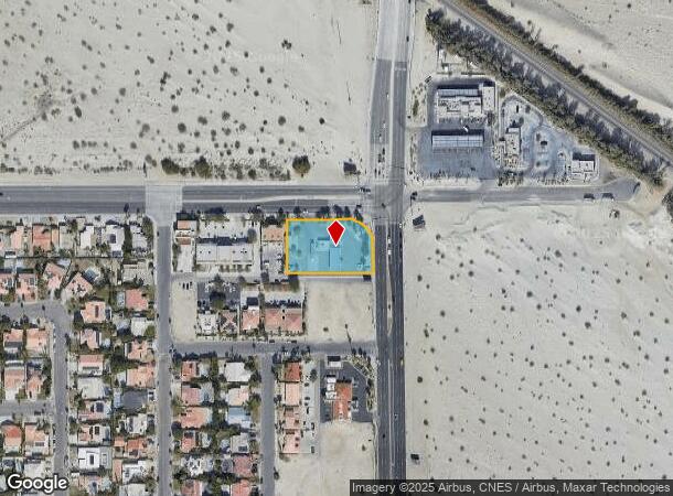
28051 Date Palm Dr, Cathedral City, CA 92234
NEARBY LISTINGS FOR SALE OR LEASE
Property Detail
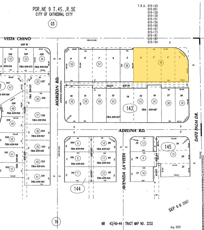
28051 Date Palm Dr
675-143-048
.94 ACRES M/L IN LOTS 1, 2, 3 & 4 MB 043/040 TR 2232
Servicestation
Riverside
A
California
06065C1577G
4
2024
0.94 AC
2025
Coachella Valley
044923
Inland Empire (California)
912 SF
Riverside-San Bernardino-Ontario, CA
DEMOGRAPHICS near 28051 Date Palm Dr
1 Mile
3 Mile
5 Mile
2024 Total Population
7,274
46,186
119,884
2029 Population
7,753
49,258
130,815
Pop Growth 2024-2029
+ 6.59%
+ 6.65%
+ 9.12%
Average Age
40
40
47
2024 Total Households
2,368
15,170
51,874
HH Growth 2024-2029
+ 6.46%
+ 6.88%
+ 9.63%
Median Household Inc
$88,496
$66,286
$65,979
Avg Household Size
3.00
2.90
2.20
2024 Avg HH Vehicles
2.00
2.00
2.00
Median Home Value
$447,702
$447,164
$567,207
Median Year Built
1991
1989
1985
Nearby Places
Map Layers
Map Styles
 Street
 Aerial
- Restaurants
- Banks
- Shops
- Fitness
- Groceries
PUBLIC TRANSPORTATION
COMMUTER RAIL
Palm Springs Amtrak (Sunset Limited - Amtrak, Texas Eagle - Amtrak)
DRIVE
WALK
Distance
Palm Springs Amtrak (Sunset Limited - Amtrak, Texas Eagle - Amtrak)
13 min
8.3 mi
AIRPORT
Palm Springs International
DRIVE
WALK
Distance
Palm Springs International
7 min
3.8 mi
Freight Ports
Port of San Diego
DRIVE
WALK
Distance
Port of San Diego
155 min
128.9 mi
Nearby Properties
Address
Land Use
TOTAL SIZE
Lot Size
Zoning
Address
Land Use
TOTAL SIZE
Lot Size
Zoning
225,833 SF
22 AC
Address
Land Use
TOTAL SIZE
Lot Size
Zoning
5,509 SF
10.06 AC
PCC
Address
Land Use
TOTAL SIZE
Lot Size
Zoning
120,754 SF
14.30 AC
Address
Land Use
TOTAL SIZE
Lot Size
Zoning
322,000 SF
19.09 AC
Address
Land Use
TOTAL SIZE
Lot Size
Zoning
133,920 SF
8.26 AC
R1
Address
Land Use
TOTAL SIZE
Lot Size
Zoning
103,526 SF
11.40 AC
Address
Land Use
TOTAL SIZE
Lot Size
Zoning
238,554 SF
13.31 AC
R1
Address
Land Use
TOTAL SIZE
Lot Size
Zoning
176,519 SF
12.60 AC
Address
Land Use
TOTAL SIZE
Lot Size
Zoning
Address
Land Use
TOTAL SIZE
Lot Size
Zoning
93,044 SF
5.81 AC
Address
Land Use
TOTAL SIZE
Lot Size
Zoning
124,636 SF
10.63 AC
Address
Land Use
TOTAL SIZE
Lot Size
Zoning
73,256 SF
21.69 AC
R2-B
Address
Land Use
TOTAL SIZE
Lot Size
Zoning
144,780 SF
15.36 AC
Address
Land Use
TOTAL SIZE
Lot Size
Zoning
114,017 SF
7.91 AC
R1
Address
Land Use
TOTAL SIZE
Lot Size
Zoning
102,579 SF
4.51 AC
M1P
Address
Land Use
TOTAL SIZE
Lot Size
Zoning
31,622 SF
3.37 AC
M1
Address
Land Use
TOTAL SIZE
Lot Size
Zoning
3,520 SF
2.63 AC
Address
Land Use
TOTAL SIZE
Lot Size
Zoning
4,026 SF
9.49 AC
R204M
Address
Land Use
TOTAL SIZE
Lot Size
Zoning
43,336 SF
6.79 AC
PUDA
Address
Land Use
TOTAL SIZE
Lot Size
Zoning
78,768 SF
8.95 AC
Address
Land Use
TOTAL SIZE
Lot Size
Zoning
60,822 SF
5.40 AC
Address
Land Use
TOTAL SIZE
Lot Size
Zoning
45,687 SF
4.15 AC
Address
Land Use
TOTAL SIZE
Lot Size
Zoning
Address
Land Use
TOTAL SIZE
Lot Size
Zoning
89,148 SF
4.88 AC
R2
Address
Land Use
TOTAL SIZE
Lot Size
Zoning
65,614 SF
6.62 AC
CPS
Address
Land Use
TOTAL SIZE
Lot Size
Zoning
28,440 SF
3.69 AC
MSC
Address
Land Use
TOTAL SIZE
Lot Size
Zoning
17,383 SF
1.67 AC
Address
Land Use
TOTAL SIZE
Lot Size
Zoning
18,949 SF
2.45 AC
Address
Land Use
TOTAL SIZE
Lot Size
Zoning
54,430 SF
2.92 AC
PCC
Address
Land Use
TOTAL SIZE
Lot Size
Zoning
18,887 SF
3.72 AC
The World's #1 Commercial Real Estate Marketplace
Connect with us
© 2025 CoStar Group
The information above has been obtained from sources believed reliable. While we do not doubt its accuracy we have not verified it and make no guarantee, warranty or representation about it. It is your responsibility to independently confirm its accuracy and completeness. Any projections, opinions, assumptions, or estimates used are for example only and do not represent the current or future performance of the property. The value of this transaction to you depends on tax and other factors which should be evaluated by your tax, financial, and legal advisors. You and your advisors should conduct a careful, independent investigation of the property to determine to your satisfaction the suitability of the property for your needs.