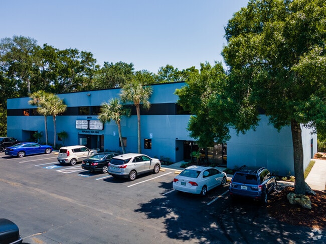
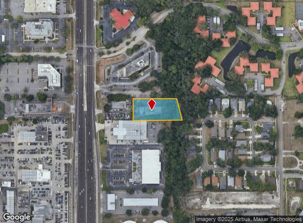
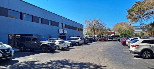
Property Record
28051 Us Highway 19 N, Clearwater, FL 33761

Current Lease Availabilities
NEARBY LISTINGS FOR SALE OR LEASE
Property Detail
28051 Us Highway 19 N
Tampa-St. Petersburg-Clearwater, FL
Belle Haven
30-28-16-07218-000-2201
BELLE HAVEN PT LOT 22 BEG NE COR SD LOT 22 FOR POB TH S13D0750E 155.57FT TH N89D5427W 339.22FT TH N00D0538E 151.40FT TH S89D5338E 303.54FT TO POB
Officebuilding
Pinellas
X
Florida
12103C0088G
22
2024
1.12 AC
2025
North Pinellas
026820
Tampa/St Petersburg
15,000 SF
DEMOGRAPHICS near 28051 Us Highway 19 N
1 Mile
3 Mile
5 Mile
2024 Total Population
13,206
103,659
218,184
2029 Population
13,295
103,556
217,709
Pop Growth 2024-2029
+ 0.67%
(0.10%)
(0.22%)
Average Age
51
49
47
2024 Total Households
7,088
48,816
98,488
HH Growth 2024-2029
+ 0.40%
(0.24%)
(0.35%)
Median Household Inc
$52,401
$61,728
$61,443
Avg Household Size
1.80
2.00
2.10
2024 Avg HH Vehicles
1.00
2.00
2.00
Median Home Value
$201,952
$275,762
$291,618
Median Year Built
1981
1981
1980
Nearby Places
- Restaurants
- Banks
- Shops
- Fitness
- Groceries
PUBLIC TRANSPORTATION
AIRPORT
St Pete-Clearwater International
DRIVE
WALK
Distance
St Pete-Clearwater International
28 min
14.6 mi
Tampa International
DRIVE
WALK
Distance
Tampa International
31 min
18.7 mi
Freight Ports
Port of Tampa Bay
DRIVE
WALK
Distance
Port of Tampa Bay
45 min
27.2 mi
Nearby Properties
Address
Land Use
TOTAL SIZE
Lot Size
Zoning
Address
Land Use
TOTAL SIZE
Lot Size
Zoning
661,982 SF
19.26 AC
Address
Land Use
TOTAL SIZE
Lot Size
Zoning
675,202 SF
43.24 AC
Address
Land Use
TOTAL SIZE
Lot Size
Zoning
724,220 SF
22.95 AC
Address
Land Use
TOTAL SIZE
Lot Size
Zoning
460,041 SF
44.28 AC
Address
Land Use
TOTAL SIZE
Lot Size
Zoning
385,080 SF
22.84 AC
Address
Land Use
TOTAL SIZE
Lot Size
Zoning
356,262 SF
15.48 AC
Address
Land Use
TOTAL SIZE
Lot Size
Zoning
167,201 SF
63.11 AC
AE
Address
Land Use
TOTAL SIZE
Lot Size
Zoning
406,729 SF
29.79 AC
CP1
Address
Land Use
TOTAL SIZE
Lot Size
Zoning
412,099 SF
49.21 AC
Address
Land Use
TOTAL SIZE
Lot Size
Zoning
326,008 SF
53.12 AC
Address
Land Use
TOTAL SIZE
Lot Size
Zoning
302,915 SF
55.33 AC
RPD75
Address
Land Use
TOTAL SIZE
Lot Size
Zoning
662,010 SF
33.76 AC
Address
Land Use
TOTAL SIZE
Lot Size
Zoning
236,972 SF
19.07 AC
Address
Land Use
TOTAL SIZE
Lot Size
Zoning
311,117 SF
16.96 AC
Address
Land Use
TOTAL SIZE
Lot Size
Zoning
241,867 SF
19.54 AC
Address
Land Use
TOTAL SIZE
Lot Size
Zoning
242,708 SF
26.17 AC
RPD10
Address
Land Use
TOTAL SIZE
Lot Size
Zoning
321,395 SF
25.22 AC
Address
Land Use
TOTAL SIZE
Lot Size
Zoning
362,238 SF
13.80 AC
Address
Land Use
TOTAL SIZE
Lot Size
Zoning
258,472 SF
18.23 AC
Address
Land Use
TOTAL SIZE
Lot Size
Zoning
239,480 SF
18.89 AC
RPD5
Address
Land Use
TOTAL SIZE
Lot Size
Zoning
215,081 SF
16.60 AC
Address
Land Use
TOTAL SIZE
Lot Size
Zoning
117,024 SF
56.52 AC
Address
Land Use
TOTAL SIZE
Lot Size
Zoning
241,170 SF
17.23 AC
Address
Land Use
TOTAL SIZE
Lot Size
Zoning
161,404 SF
18.48 AC
CP2
Address
Land Use
TOTAL SIZE
Lot Size
Zoning
294,022 SF
15.75 AC
RPD5
Address
Land Use
TOTAL SIZE
Lot Size
Zoning
191,375 SF
13.58 AC
AE
Address
Land Use
TOTAL SIZE
Lot Size
Zoning
186,967 SF
16.86 AC
Address
Land Use
TOTAL SIZE
Lot Size
Zoning
199,825 SF
22.75 AC
R2
Address
Land Use
TOTAL SIZE
Lot Size
Zoning
250,113 SF
39.50 AC
Address
Land Use
TOTAL SIZE
Lot Size
Zoning
145,000 SF
1.26 AC
The World's #1 Commercial Real Estate Marketplace
Connect with us
© 2025 CoStar Group
The information above has been obtained from sources believed reliable. While we do not doubt its accuracy we have not verified it and make no guarantee, warranty or representation about it. It is your responsibility to independently confirm its accuracy and completeness. Any projections, opinions, assumptions, or estimates used are for example only and do not represent the current or future performance of the property. The value of this transaction to you depends on tax and other factors which should be evaluated by your tax, financial, and legal advisors. You and your advisors should conduct a careful, independent investigation of the property to determine to your satisfaction the suitability of the property for your needs.