Property Record
28067 State Highway 74, Perris, CA 92570

Save to a Folder
{{folder.Name}}
{{folder.ListingIds.length}} Properties
{{folder.ListingIds.length}} Property
Create a New Folder
Property Detail
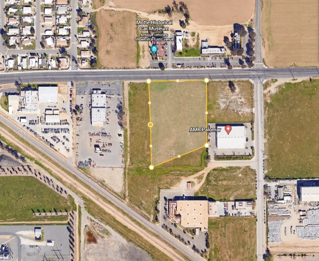
28067 State Highway 74
Riverside-San Bernardino-Ontario, CA
5.22 ACRES M/L IN POR LOTS 758, 759, 774 & 775 MB 014/063 ROMOLA FARMS 6A
331-190-033
RIVERSIDE
Residentialacreage
California
RR
758
B and X Area of moderate flood hazard, usually the area between the limits of the 100-year and 500-year floods.
5.22 AC
2025
South Riverside
2026
Inland Empire (California)
042728
NEARBY LISTINGS FOR SALE OR LEASE
DEMOGRAPHICS near 28067 State Highway 74
1 mile
3 mile
5 mile
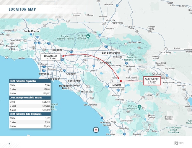
2025 Total Population
4,781
44,618
131,397
2030 Population
4,993
46,545
136,935
Pop Growth 2025-2030
+ 4.43%
+ 4.32%
+ 4.21%
Average Age
37
41
39
2025 Total Households
1,321
15,059
41,371
HH Growth 2025-2030
+ 4.47%
+ 3.71%
+ 3.70%
Median Household Inc
$80,000
$77,089
$81,795
Avg Household Size
3.40
2.90
3.10
2025 Avg HH Vehicles
3.00
2.00
2.00
Median Home Value
$486,653
$471,310
$499,122
Median Year Built
1993
1994
1996
Nearby Places
Map Layers
Map Styles
 Street
 Aerial
Layers
 Traffic
 Biking
Places
Listings with unknown addresses are not visible on the map
- Restaurants
- Banks
- Shops
- Fitness
- Groceries
PUBLIC TRANSPORTATION
COMMUTER RAIL
South Perris (Metrolink 91-Perris Valley Line - Metrolink Trains)
Drive
Walk
Distance
South Perris (Metrolink 91-Perris Valley Line - Metrolink Trains)
6 min
3.2 mi
Perris Downtown (Metrolink 91-Perris Valley Line - Metrolink Trains)
Drive
Walk
Distance
Perris Downtown (Metrolink 91-Perris Valley Line - Metrolink Trains)
9 min
5.9 mi
Freight Ports
Port of Long Beach
Drive
Walk
Distance
Port of Long Beach
99 min
73.8 mi
SALE & LEASE HISTORY
LISTING DATE
SALE/LEASE

May 05, 2022
For Sale
Jul 19, 2023
For Sale
Jul 13, 2026
For Sale
Aug 14, 2024
For Sale
Nearby Properties
Address
Land Use
TOTAL SIZE
Lot Size
Zoning
Address
Land Use
TOTAL SIZE
Lot Size
Zoning
123,058 SF
Address
Land Use
TOTAL SIZE
Lot Size
Zoning
123,058 SF
17.09 AC
R3
Address
Land Use
TOTAL SIZE
Lot Size
Zoning
27.07 AC
Address
Land Use
TOTAL SIZE
Lot Size
Zoning
Address
Land Use
TOTAL SIZE
Lot Size
Zoning
9.22 AC
CBOOK
Address
Land Use
TOTAL SIZE
Lot Size
Zoning
150,372 SF
Address
Land Use
TOTAL SIZE
Lot Size
Zoning
40,349 SF
9.89 AC
R3
Address
Land Use
TOTAL SIZE
Lot Size
Zoning
61,487 SF
5.73 AC
Address
Land Use
TOTAL SIZE
Lot Size
Zoning
104,208 SF
10.96 AC
Address
Land Use
TOTAL SIZE
Lot Size
Zoning
13.95 AC
Address
Land Use
TOTAL SIZE
Lot Size
Zoning
83,814 SF
8.87 AC
CPS
Address
Land Use
TOTAL SIZE
Lot Size
Zoning
97,942 SF
11 AC
Address
Land Use
TOTAL SIZE
Lot Size
Zoning
86,590 SF
10.97 AC
MM
Address
Land Use
TOTAL SIZE
Lot Size
Zoning
27,252 SF
5.42 AC
R6
Address
Land Use
TOTAL SIZE
Lot Size
Zoning
41,840 SF
8.92 AC
Address
Land Use
TOTAL SIZE
Lot Size
Zoning
86,403 SF
6.17 AC
R2
Address
Land Use
TOTAL SIZE
Lot Size
Zoning
29,598 SF
3.26 AC
Address
Land Use
TOTAL SIZE
Lot Size
Zoning
24,889 SF
42.36 AC
Address
Land Use
TOTAL SIZE
Lot Size
Zoning
59,066 SF
Address
Land Use
TOTAL SIZE
Lot Size
Zoning
59,066 SF
4.80 AC
C1CP
Address
Land Use
TOTAL SIZE
Lot Size
Zoning
70,680 SF
4.59 AC
M-M
Address
Land Use
TOTAL SIZE
Lot Size
Zoning
68,986 SF
7.21 AC
CPS
Address
Land Use
TOTAL SIZE
Lot Size
Zoning
28,428 SF
1.97 AC
CICP
Address
Land Use
TOTAL SIZE
Lot Size
Zoning
13,808 SF
2.82 AC
R2
Address
Land Use
TOTAL SIZE
Lot Size
Zoning
11,200 SF
11.05 AC
MM
Address
Land Use
TOTAL SIZE
Lot Size
Zoning
54,282 SF
3.87 AC
MSC
Address
Land Use
TOTAL SIZE
Lot Size
Zoning
6,100 SF
Address
Land Use
TOTAL SIZE
Lot Size
Zoning
6,100 SF
3.14 AC
The World's #1 Commercial Real Estate Marketplace
Connect with us
© 2026 CoStar Group
The information above has been obtained from sources believed reliable. While we do not doubt its accuracy we have not verified it and make no guarantee, warranty or representation about it. It is your responsibility to independently confirm its accuracy and completeness. Any projections, opinions, assumptions, or estimates used are for example only and do not represent the current or future performance of the property. The value of this transaction to you depends on tax and other factors which should be evaluated by your tax, financial, and legal advisors. You and your advisors should conduct a careful, independent investigation of the property to determine to your satisfaction the suitability of the property for your needs.