Property Record
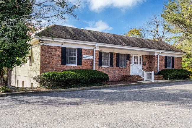
2807 Hurley Pond Rd, Wall Township, NJ 07719


This Property Is For Sale
NEARBY LISTINGS FOR SALE OR LEASE
Property Detail
2807 Hurley Pond Rd
52-00772-0000-00027
Monmouth
Commercialnec
New Jersey
X
27
34025C0340F
1.49 AC
2024
Southern Monmouth
2025
Northern New Jersey
808600
Lakewood-New Brunswick, NJ
5,120 SF
DEMOGRAPHICS near 2807 Hurley Pond Rd
1 Mile
3 Mile
5 Mile
2024 Total Population
4,968
49,296
133,347
2029 Population
4,986
50,047
135,758
Pop Growth 2024-2029
+ 0.36%
+ 1.52%
+ 1.81%
Average Age
45
45
45
2024 Total Households
1,793
20,459
56,141
HH Growth 2024-2029
+ 0.11%
+ 1.46%
+ 1.85%
Median Household Inc
$149,756
$116,194
$110,549
Avg Household Size
2.60
2.30
2.30
2024 Avg HH Vehicles
2.00
2.00
2.00
Median Home Value
$685,873
$683,065
$699,983
Median Year Built
1982
1969
1969
Nearby Places
Map Layers
Map Styles
 Street
 Aerial
- Restaurants
- Banks
- Shops
- Fitness
- Groceries
PUBLIC TRANSPORTATION
COMMUTER RAIL
Belmar (North Jersey Coast Line - NJ Transit Commuter Rail (NJ Transit))
DRIVE
WALK
Distance
Belmar (North Jersey Coast Line - NJ Transit Commuter Rail (NJ Transit))
7 min
3.3 mi
Bradley Beach (North Jersey Coast Line - NJ Transit Commuter Rail (NJ Transit))
DRIVE
WALK
Distance
Bradley Beach (North Jersey Coast Line - NJ Transit Commuter Rail (NJ Transit))
9 min
4.8 mi
Freight Ports
New York Container Terminal
DRIVE
WALK
Distance
New York Container Terminal
60 min
45.0 mi
Nearby Properties
Address
Land Use
TOTAL SIZE
Lot Size
Zoning
Address
Land Use
TOTAL SIZE
Lot Size
Zoning
1,846 SF
23.23 AC
R-2
Address
Land Use
TOTAL SIZE
Lot Size
Zoning
23,868 SF
137.35 AC
R-1
Address
Land Use
TOTAL SIZE
Lot Size
Zoning
190,893 SF
36.69 AC
POS
Address
Land Use
TOTAL SIZE
Lot Size
Zoning
49,657 SF
11.22 AC
HB80
Address
Land Use
TOTAL SIZE
Lot Size
Zoning
3,094 SF
277.60 AC
C
Address
Land Use
TOTAL SIZE
Lot Size
Zoning
7.79 AC
MLCC
Address
Land Use
TOTAL SIZE
Lot Size
Zoning
9.30 AC
SF05
Address
Land Use
TOTAL SIZE
Lot Size
Zoning
3.44 AC
SF05
Address
Land Use
TOTAL SIZE
Lot Size
Zoning
13,200 SF
18.63 AC
PUDR
Address
Land Use
TOTAL SIZE
Lot Size
Zoning
17,586 SF
386.01 AC
POS
Address
Land Use
TOTAL SIZE
Lot Size
Zoning
84,297 SF
42.37 AC
CR40
Address
Land Use
TOTAL SIZE
Lot Size
Zoning
145,918 SF
20.31 AC
OR-5
Address
Land Use
TOTAL SIZE
Lot Size
Zoning
8.82 AC
R2
Address
Land Use
TOTAL SIZE
Lot Size
Zoning
49,170 SF
8.38 AC
HB80
Address
Land Use
TOTAL SIZE
Lot Size
Zoning
45,236 SF
48.30 AC
POS
Address
Land Use
TOTAL SIZE
Lot Size
Zoning
27,328 SF
6.79 AC
HB12
Address
Land Use
TOTAL SIZE
Lot Size
Zoning
28,819 SF
13.59 AC
ES
Address
Land Use
TOTAL SIZE
Lot Size
Zoning
26.05 AC
SF10
Address
Land Use
TOTAL SIZE
Lot Size
Zoning
0.86 AC
R-1
Address
Land Use
TOTAL SIZE
Lot Size
Zoning
7.39 AC
R2
Address
Land Use
TOTAL SIZE
Lot Size
Zoning
8.76 AC
R1
Address
Land Use
TOTAL SIZE
Lot Size
Zoning
86,051 SF
9.41 AC
HB12
Address
Land Use
TOTAL SIZE
Lot Size
Zoning
6.43 AC
SF05
Address
Land Use
TOTAL SIZE
Lot Size
Zoning
115,960 SF
17.93 AC
OR-5
Address
Land Use
TOTAL SIZE
Lot Size
Zoning
111,580 SF
25 AC
POS
Address
Land Use
TOTAL SIZE
Lot Size
Zoning
3,400 SF
262.97 AC
AI
Address
Land Use
TOTAL SIZE
Lot Size
Zoning
8.83 AC
R-2
Address
Land Use
TOTAL SIZE
Lot Size
Zoning
8,749 SF
5.73 AC
OPML
Address
Land Use
TOTAL SIZE
Lot Size
Zoning
1,284 SF
6.97 AC
R-2
Address
Land Use
TOTAL SIZE
Lot Size
Zoning
13,094 SF
HB80
The World's #1 Commercial Real Estate Marketplace
Connect with us
© 2026 CoStar Group
The information above has been obtained from sources believed reliable. While we do not doubt its accuracy we have not verified it and make no guarantee, warranty or representation about it. It is your responsibility to independently confirm its accuracy and completeness. Any projections, opinions, assumptions, or estimates used are for example only and do not represent the current or future performance of the property. The value of this transaction to you depends on tax and other factors which should be evaluated by your tax, financial, and legal advisors. You and your advisors should conduct a careful, independent investigation of the property to determine to your satisfaction the suitability of the property for your needs.