Property Record
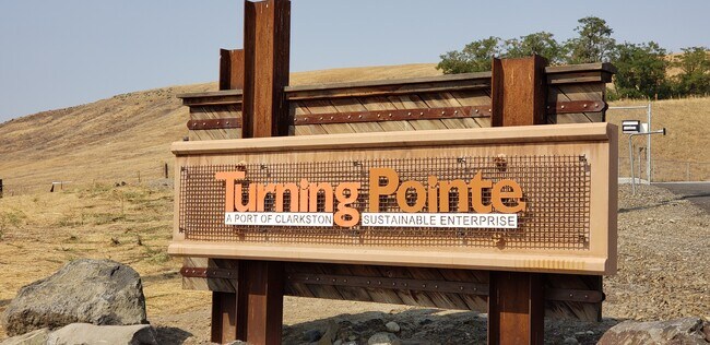
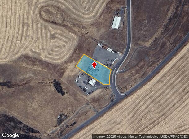
2807 Turning Pointe Loop, Clarkston, WA 99403
NEARBY LISTINGS FOR SALE OR LEASE
-
-
View all Clarkston listings for sale on LoopNet.com
Property Detail
2807 Turning Pointe Loop
Coeur D'Alene
Turning Pointe Business
Lewiston, ID-WA
TURNING POINTE BUSINESS PARK ADDN BLK 4 LOT 2
1-767-00-002-0000-0000
Asotin
Commercialnec
Washington
2024
2
2025
0.94 AC
960200
Asotin
DEMOGRAPHICS near 2807 Turning Pointe Loop
1 Mile
3 Mile
5 Mile
2024 Total Population
1,155
14,760
34,822
2029 Population
1,194
15,293
36,206
Pop Growth 2024-2029
+ 3.38%
+ 3.61%
+ 3.97%
Average Age
47
45
42
2024 Total Households
458
6,147
14,404
HH Growth 2024-2029
+ 3.49%
+ 3.63%
+ 3.96%
Median Household Inc
$92,058
$65,292
$62,202
Avg Household Size
2.50
2.40
2.30
2024 Avg HH Vehicles
3.00
2.00
2.00
Median Home Value
$361,724
$297,179
$273,436
Median Year Built
1994
1981
1971
Nearby Places
Map Layers
Map Styles
 Street
 Aerial
- Restaurants
- Banks
- Shops
- Fitness
- Groceries
PUBLIC TRANSPORTATION
AIRPORT
Lewiston/Nez Perce County
DRIVE
WALK
Distance
Lewiston/Nez Perce County
19 min
8.6 mi
Pullman/Moscow Regional
DRIVE
WALK
Distance
Pullman/Moscow Regional
65 min
45.1 mi
Freight Ports
Port of Tacoma
DRIVE
WALK
Distance
Port of Tacoma
419 min
318.9 mi
SALE & LEASE HISTORY
LISTING DATE
SALE/LEASE

Aug 24, 2021
For Sale
Nearby Properties
Address
Land Use
TOTAL SIZE
Lot Size
Zoning
Address
Land Use
TOTAL SIZE
Lot Size
Zoning
0.48 AC
Address
Land Use
TOTAL SIZE
Lot Size
Zoning
18.85 AC
11
Address
Land Use
TOTAL SIZE
Lot Size
Zoning
25,810 SF
2.21 AC
Address
Land Use
TOTAL SIZE
Lot Size
Zoning
2.24 AC
Address
Land Use
TOTAL SIZE
Lot Size
Zoning
6.83 AC
Address
Land Use
TOTAL SIZE
Lot Size
Zoning
41,940 SF
1.68 AC
Address
Land Use
TOTAL SIZE
Lot Size
Zoning
16,126 SF
2.88 AC
Address
Land Use
TOTAL SIZE
Lot Size
Zoning
22,660 SF
7.43 AC
Address
Land Use
TOTAL SIZE
Lot Size
Zoning
22,264 SF
0.50 AC
Address
Land Use
TOTAL SIZE
Lot Size
Zoning
30,002 SF
1.51 AC
Address
Land Use
TOTAL SIZE
Lot Size
Zoning
11,574 SF
1.66 AC
Address
Land Use
TOTAL SIZE
Lot Size
Zoning
42,579 SF
5.74 AC
Address
Land Use
TOTAL SIZE
Lot Size
Zoning
1,647 SF
2.48 AC
Address
Land Use
TOTAL SIZE
Lot Size
Zoning
38,340 SF
2.67 AC
Address
Land Use
TOTAL SIZE
Lot Size
Zoning
45,476 SF
2.56 AC
Address
Land Use
TOTAL SIZE
Lot Size
Zoning
Address
Land Use
TOTAL SIZE
Lot Size
Zoning
1.45 AC
Address
Land Use
TOTAL SIZE
Lot Size
Zoning
3,360 SF
1.29 AC
Address
Land Use
TOTAL SIZE
Lot Size
Zoning
10,974 SF
4.33 AC
Address
Land Use
TOTAL SIZE
Lot Size
Zoning
3,360 SF
1.29 AC
Address
Land Use
TOTAL SIZE
Lot Size
Zoning
3,616 SF
2.33 AC
Address
Land Use
TOTAL SIZE
Lot Size
Zoning
12,504 SF
1.59 AC
Address
Land Use
TOTAL SIZE
Lot Size
Zoning
10,800 SF
3.73 AC
Address
Land Use
TOTAL SIZE
Lot Size
Zoning
65,472 SF
5.21 AC
1
Address
Land Use
TOTAL SIZE
Lot Size
Zoning
11.34 AC
Address
Land Use
TOTAL SIZE
Lot Size
Zoning
1,791 SF
0.63 AC
Address
Land Use
TOTAL SIZE
Lot Size
Zoning
133.22 AC
3
Address
Land Use
TOTAL SIZE
Lot Size
Zoning
3,132 SF
1.68 AC
Address
Land Use
TOTAL SIZE
Lot Size
Zoning
12,100 SF
4.71 AC
Address
Land Use
TOTAL SIZE
Lot Size
Zoning
17,500 SF
4.43 AC
The World's #1 Commercial Real Estate Marketplace
Connect with us
© 2025 CoStar Group
The information above has been obtained from sources believed reliable. While we do not doubt its accuracy we have not verified it and make no guarantee, warranty or representation about it. It is your responsibility to independently confirm its accuracy and completeness. Any projections, opinions, assumptions, or estimates used are for example only and do not represent the current or future performance of the property. The value of this transaction to you depends on tax and other factors which should be evaluated by your tax, financial, and legal advisors. You and your advisors should conduct a careful, independent investigation of the property to determine to your satisfaction the suitability of the property for your needs.