Property Record
28080 Waltz Rd, New Boston, MI 48164


This Property Is For Sale
NEARBY LISTINGS FOR SALE OR LEASE
-
-
View all New Boston listings for sale on LoopNet.com
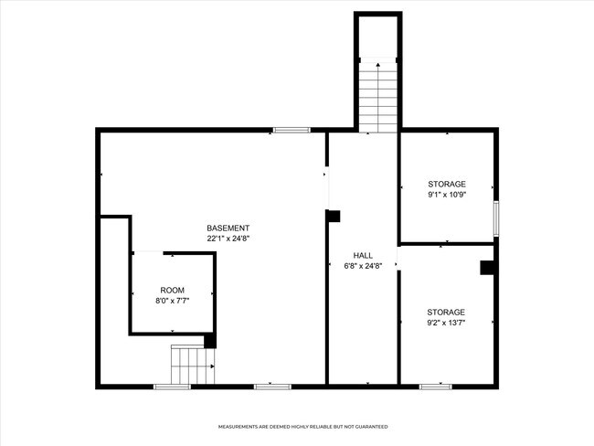
Property Detail
28080 Waltz Rd
Detroit-Warren-Dearborn, MI
Supervisors Huron Plat No 6
75-127-01-0276-000
32A276 LOT 276 SUPERVISORS HURON PLAT NO. 6 T4S R9E L68 P30 WCR
Restaurantbuilding
Wayne
X
Michigan
26115C0085E
276
2024
0.20 AC
2025
Airport District
590401
Detroit
3,200 SF
DEMOGRAPHICS near 28080 Waltz Rd
1 Mile
3 Mile
5 Mile
2024 Total Population
1,013
7,456
23,131
2029 Population
978
7,312
22,759
Pop Growth 2024-2029
(3.46%)
(1.93%)
(1.61%)
Average Age
43
41
42
2024 Total Households
383
2,733
8,790
HH Growth 2024-2029
(3.66%)
(1.68%)
(1.40%)
Median Household Inc
$143,269
$85,116
$80,771
Avg Household Size
2.60
2.70
2.60
2024 Avg HH Vehicles
2.00
2.00
2.00
Median Home Value
$298,900
$269,518
$264,207
Median Year Built
1980
1990
1989
Nearby Places
Map Layers
Map Styles
 Street
 Aerial
- Restaurants
- Banks
- Shops
- Fitness
- Groceries
PUBLIC TRANSPORTATION
AIRPORT
Detroit Metro Wayne County
DRIVE
WALK
Distance
Detroit Metro Wayne County
20 min
12.3 mi
Windsor International
DRIVE
WALK
Distance
Windsor International
60 min
36.7 mi
Nearby Properties
Address
Land Use
TOTAL SIZE
Lot Size
Zoning
Address
Land Use
TOTAL SIZE
Lot Size
Zoning
323,057 SF
Address
Land Use
TOTAL SIZE
Lot Size
Zoning
323,057 SF
39.75 AC
I3 PLAN
Address
Land Use
TOTAL SIZE
Lot Size
Zoning
169,300 SF
229.95 AC
Address
Land Use
TOTAL SIZE
Lot Size
Zoning
285,251 SF
17.27 AC
I3 PLAN
Address
Land Use
TOTAL SIZE
Lot Size
Zoning
195,000 SF
31.38 AC
Address
Land Use
TOTAL SIZE
Lot Size
Zoning
381,545 SF
30.90 AC
I3 PLAN
Address
Land Use
TOTAL SIZE
Lot Size
Zoning
796,126 SF
54 AC
Address
Land Use
TOTAL SIZE
Lot Size
Zoning
96,940 SF
10.02 AC
I3 PLAN
Address
Land Use
TOTAL SIZE
Lot Size
Zoning
46,948 SF
19.70 AC
I2 HEAV
Address
Land Use
TOTAL SIZE
Lot Size
Zoning
54,852 SF
26.46 AC
I3 PLAN
Address
Land Use
TOTAL SIZE
Lot Size
Zoning
91,075 SF
9.07 AC
Address
Land Use
TOTAL SIZE
Lot Size
Zoning
43,724 SF
7.79 AC
I3 PLAN
Address
Land Use
TOTAL SIZE
Lot Size
Zoning
26.54 AC
MHP MOB
Address
Land Use
TOTAL SIZE
Lot Size
Zoning
Address
Land Use
TOTAL SIZE
Lot Size
Zoning
Address
Land Use
TOTAL SIZE
Lot Size
Zoning
2,304 SF
50.50 AC
Address
Land Use
TOTAL SIZE
Lot Size
Zoning
75.90 AC
Address
Land Use
TOTAL SIZE
Lot Size
Zoning
1,422 SF
84.24 AC
Address
Land Use
TOTAL SIZE
Lot Size
Zoning
37,661 SF
10.02 AC
Address
Land Use
TOTAL SIZE
Lot Size
Zoning
27,567 SF
11.46 AC
Address
Land Use
TOTAL SIZE
Lot Size
Zoning
77.45 AC
Address
Land Use
TOTAL SIZE
Lot Size
Zoning
2,589 SF
10.75 AC
MHP MOB
Address
Land Use
TOTAL SIZE
Lot Size
Zoning
1,422 SF
74.65 AC
Address
Land Use
TOTAL SIZE
Lot Size
Zoning
72,151 SF
8.47 AC
Address
Land Use
TOTAL SIZE
Lot Size
Zoning
1,463 SF
70.93 AC
Address
Land Use
TOTAL SIZE
Lot Size
Zoning
6,141 SF
5.07 AC
B2 GENE
Address
Land Use
TOTAL SIZE
Lot Size
Zoning
19,133 SF
19.61 AC
Address
Land Use
TOTAL SIZE
Lot Size
Zoning
81.31 AC
AG AGRI
Address
Land Use
TOTAL SIZE
Lot Size
Zoning
8.65 AC
MHP MOB
Address
Land Use
TOTAL SIZE
Lot Size
Zoning
59.39 AC
The World's #1 Commercial Real Estate Marketplace
Connect with us
© 2026 CoStar Group
The information above has been obtained from sources believed reliable. While we do not doubt its accuracy we have not verified it and make no guarantee, warranty or representation about it. It is your responsibility to independently confirm its accuracy and completeness. Any projections, opinions, assumptions, or estimates used are for example only and do not represent the current or future performance of the property. The value of this transaction to you depends on tax and other factors which should be evaluated by your tax, financial, and legal advisors. You and your advisors should conduct a careful, independent investigation of the property to determine to your satisfaction the suitability of the property for your needs.