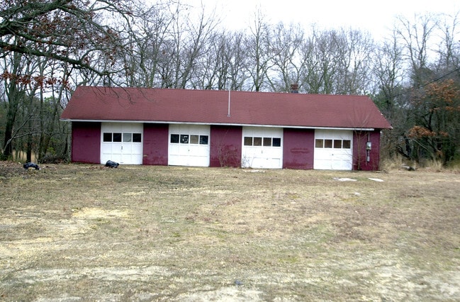
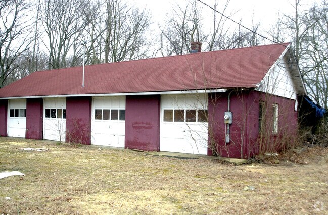
Property Record
2809 W Bangs Ave, Neptune, NJ 07753


NEARBY LISTINGS FOR SALE OR LEASE
Property Detail
2809 W Bangs Ave
35-02101-0000-00001
Monmouth
Autorepair
New Jersey
X
1
34025C0331F
1.03 AC
2024
Southern Monmouth
2025
Northern New Jersey
807800
New York-Jersey City-White Plains, NY-NJ
1,500 SF
DEMOGRAPHICS near 2809 W Bangs Ave
1 Mile
3 Mile
5 Mile
2024 Total Population
9,406
86,465
144,213
2029 Population
9,434
86,796
145,635
Pop Growth 2024-2029
+ 0.30%
+ 0.38%
+ 0.99%
Average Age
45
44
44
2024 Total Households
3,551
37,644
61,023
HH Growth 2024-2029
+ 0.11%
+ 0.37%
+ 0.92%
Median Household Inc
$99,203
$85,963
$91,809
Avg Household Size
2.50
2.20
2.30
2024 Avg HH Vehicles
2.00
2.00
2.00
Median Home Value
$395,237
$450,379
$503,272
Median Year Built
1978
1968
1969
Nearby Places
Map Layers
Map Styles
 Street
 Aerial
- Restaurants
- Banks
- Shops
- Fitness
- Groceries
PUBLIC TRANSPORTATION
COMMUTER RAIL
Asbury Park (North Jersey Coast Line - NJ Transit Commuter Rail (NJ Transit))
DRIVE
WALK
Distance
Asbury Park (North Jersey Coast Line - NJ Transit Commuter Rail (NJ Transit))
8 min
2.8 mi
Bradley Beach (North Jersey Coast Line - NJ Transit Commuter Rail (NJ Transit))
DRIVE
WALK
Distance
Bradley Beach (North Jersey Coast Line - NJ Transit Commuter Rail (NJ Transit))
7 min
3.0 mi
AIRPORT
Newark Liberty International
DRIVE
WALK
Distance
Newark Liberty International
62 min
46.1 mi
Freight Ports
New York Container Terminal
DRIVE
WALK
Distance
New York Container Terminal
55 min
40.5 mi
Nearby Properties
Address
Land Use
TOTAL SIZE
Lot Size
Zoning
Address
Land Use
TOTAL SIZE
Lot Size
Zoning
26,282 SF
4.59 AC
C
Address
Land Use
TOTAL SIZE
Lot Size
Zoning
434,405 SF
52.92 AC
RT66
Address
Land Use
TOTAL SIZE
Lot Size
Zoning
4,289 SF
94.37 AC
CCRC
Address
Land Use
TOTAL SIZE
Lot Size
Zoning
739,651 SF
27.89 AC
C
Address
Land Use
TOTAL SIZE
Lot Size
Zoning
65,668 SF
111.60 AC
C50
Address
Land Use
TOTAL SIZE
Lot Size
Zoning
35.50 AC
R-7
Address
Land Use
TOTAL SIZE
Lot Size
Zoning
37.47 AC
AH
Address
Land Use
TOTAL SIZE
Lot Size
Zoning
320,341 SF
57.85 AC
C
Address
Land Use
TOTAL SIZE
Lot Size
Zoning
1,100 SF
37.83 AC
C-2
Address
Land Use
TOTAL SIZE
Lot Size
Zoning
32.19 AC
R-7
Address
Land Use
TOTAL SIZE
Lot Size
Zoning
25.37 AC
C-1
Address
Land Use
TOTAL SIZE
Lot Size
Zoning
1.61 AC
R1
Address
Land Use
TOTAL SIZE
Lot Size
Zoning
201,455 SF
79.34 AC
R-1
Address
Land Use
TOTAL SIZE
Lot Size
Zoning
20.62 AC
AR3P
Address
Land Use
TOTAL SIZE
Lot Size
Zoning
1,152 SF
87 SF
WPRA
Address
Land Use
TOTAL SIZE
Lot Size
Zoning
108,641 SF
10.64 AC
C-6
Address
Land Use
TOTAL SIZE
Lot Size
Zoning
181,064 SF
14.62 AC
IL
Address
Land Use
TOTAL SIZE
Lot Size
Zoning
1,288 SF
25.49 AC
HD-R
Address
Land Use
TOTAL SIZE
Lot Size
Zoning
5,407 SF
25.60 AC
C-3
Address
Land Use
TOTAL SIZE
Lot Size
Zoning
1,178 SF
21.78 AC
R-7
Address
Land Use
TOTAL SIZE
Lot Size
Zoning
3,094 SF
277.60 AC
C
Address
Land Use
TOTAL SIZE
Lot Size
Zoning
224,683 SF
21.56 AC
CHS
Address
Land Use
TOTAL SIZE
Lot Size
Zoning
91,173 SF
4.07 AC
R3
Address
Land Use
TOTAL SIZE
Lot Size
Zoning
Address
Land Use
TOTAL SIZE
Lot Size
Zoning
183,932 SF
23.51 AC
IL
Address
Land Use
TOTAL SIZE
Lot Size
Zoning
13,200 SF
18.63 AC
PUDR
Address
Land Use
TOTAL SIZE
Lot Size
Zoning
1,487 SF
7.50 AC
R-B
Address
Land Use
TOTAL SIZE
Lot Size
Zoning
15 AC
R-7
Address
Land Use
TOTAL SIZE
Lot Size
Zoning
34,590 SF
18.38 AC
C-2
Address
Land Use
TOTAL SIZE
Lot Size
Zoning
0.88 AC
STNB
The World's #1 Commercial Real Estate Marketplace
Connect with us
© 2026 CoStar Group
The information above has been obtained from sources believed reliable. While we do not doubt its accuracy we have not verified it and make no guarantee, warranty or representation about it. It is your responsibility to independently confirm its accuracy and completeness. Any projections, opinions, assumptions, or estimates used are for example only and do not represent the current or future performance of the property. The value of this transaction to you depends on tax and other factors which should be evaluated by your tax, financial, and legal advisors. You and your advisors should conduct a careful, independent investigation of the property to determine to your satisfaction the suitability of the property for your needs.