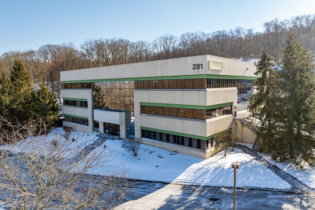
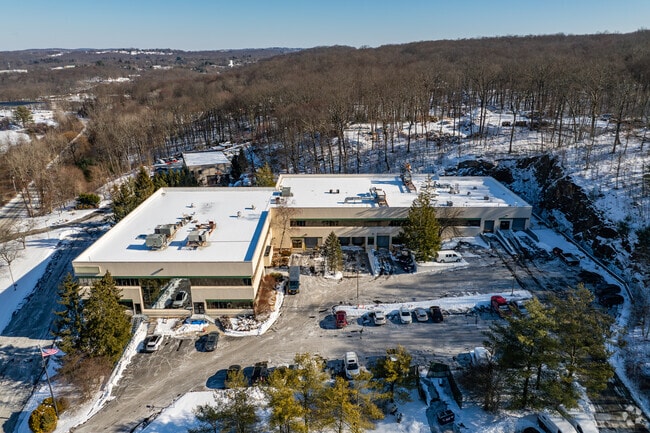
Property Record
281 Fields Ln, Brewster, NY 10509

Current Lease Availabilities
Property Detail
281 Fields Ln
373089-078-000-0002-094-000-0000
Putnam
Warehouse
New York
OP1
94.00
B and X Area of moderate flood hazard, usually the area between the limits of the 100-year and 500-year floods.
4.87 AC
2024
Brewster
2024
Westchester/So Connecticut
011700
New York-Jersey City-White Plains, NY-NJ
52,800 SF
NEARBY LISTINGS FOR SALE OR LEASE
-
-
View all Brewster listings for lease on LoopNet.com
DEMOGRAPHICS near 281 Fields Ln
1 mile
3 mile
5 mile
2025 Total Population
943
12,779
41,897
2030 Population
945
12,782
42,005
Pop Growth 2025-2030
+ 0.21%
+ 0.02%
+ 0.26%
Average Age
45
44
46
2025 Total Households
368
4,691
16,200
HH Growth 2025-2030
+ 0.27%
(0.06%)
+ 0.32%
Median Household Inc
$142,241
$140,070
$131,240
Avg Household Size
2.50
2.60
2.50
2025 Avg HH Vehicles
2.00
2.00
2.00
Median Home Value
$539,655
$587,398
$564,933
Median Year Built
1979
1969
1974
Nearby Places
Map Layers
Map Styles
 Street
 Aerial
Layers
 Traffic
 Biking
Places
Listings with unknown addresses are not visible on the map
- Restaurants
- Banks
- Shops
- Fitness
- Groceries
PUBLIC TRANSPORTATION
COMMUTER RAIL
Croton Falls Station (Harlem Line - Metro-North Commuter Railroad Company (Metro-North))
Drive
Walk
Distance
Croton Falls Station (Harlem Line - Metro-North Commuter Railroad Company (Metro-North))
8 min
2.5 mi
Brewster Station (Harlem Line - Metro-North Commuter Railroad Company (Metro-North))
Drive
Walk
Distance
Brewster Station (Harlem Line - Metro-North Commuter Railroad Company (Metro-North))
12 min
4.0 mi
AIRPORT
Westchester County
Drive
Walk
Distance
Westchester County
32 min
22.3 mi
New York Stewart International
Drive
Walk
Distance
New York Stewart International
60 min
42.2 mi
Freight Ports
Port of New Haven
Drive
Walk
Distance
Port of New Haven
76 min
49.9 mi
Nearby Properties
Address
Land Use
TOTAL SIZE
Lot Size
Zoning
Address
Land Use
TOTAL SIZE
Lot Size
Zoning
20,298 SF
331.64 AC
NW
Address
Land Use
TOTAL SIZE
Lot Size
Zoning
38.19 AC
Address
Land Use
TOTAL SIZE
Lot Size
Zoning
670.72 AC
SP Z
Address
Land Use
TOTAL SIZE
Lot Size
Zoning
1,193 SF
94.75 AC
NW
Address
Land Use
TOTAL SIZE
Lot Size
Zoning
306.87 AC
SP Z
Address
Land Use
TOTAL SIZE
Lot Size
Zoning
172,197 SF
43.18 AC
R
Address
Land Use
TOTAL SIZE
Lot Size
Zoning
110,970 SF
0.01 AC
R
Address
Land Use
TOTAL SIZE
Lot Size
Zoning
838.90 AC
Address
Land Use
TOTAL SIZE
Lot Size
Zoning
94,431 SF
0.01 AC
R
Address
Land Use
TOTAL SIZE
Lot Size
Zoning
99,900 SF
21.48 AC
OP1
Address
Land Use
TOTAL SIZE
Lot Size
Zoning
67.30 AC
Address
Land Use
TOTAL SIZE
Lot Size
Zoning
42.30 AC
Address
Land Use
TOTAL SIZE
Lot Size
Zoning
22,338 SF
2.37 AC
C
Address
Land Use
TOTAL SIZE
Lot Size
Zoning
3,060 SF
2.47 AC
R40
Address
Land Use
TOTAL SIZE
Lot Size
Zoning
66,037 SF
1.61 AC
R
Address
Land Use
TOTAL SIZE
Lot Size
Zoning
34.20 AC
Address
Land Use
TOTAL SIZE
Lot Size
Zoning
69.71 AC
Address
Land Use
TOTAL SIZE
Lot Size
Zoning
163.38 AC
Address
Land Use
TOTAL SIZE
Lot Size
Zoning
122,160 SF
6.84 AC
OP1
Address
Land Use
TOTAL SIZE
Lot Size
Zoning
426.60 AC
NW
Address
Land Use
TOTAL SIZE
Lot Size
Zoning
159.80 AC
Address
Land Use
TOTAL SIZE
Lot Size
Zoning
Address
Land Use
TOTAL SIZE
Lot Size
Zoning
10 AC
Address
Land Use
TOTAL SIZE
Lot Size
Zoning
40,500 SF
3.91 AC
OP1
Address
Land Use
TOTAL SIZE
Lot Size
Zoning
864 SF
4.77 AC
R
Address
Land Use
TOTAL SIZE
Lot Size
Zoning
88,960 SF
4.20 AC
OP1
Address
Land Use
TOTAL SIZE
Lot Size
Zoning
39.20 AC
Address
Land Use
TOTAL SIZE
Lot Size
Zoning
51,200 SF
8.71 AC
OP1
Address
Land Use
TOTAL SIZE
Lot Size
Zoning
59,080 SF
6.40 AC
OP1
The World's #1 Commercial Real Estate Marketplace
Connect with us
© 2026 CoStar Group
The information above has been obtained from sources believed reliable. While we do not doubt its accuracy we have not verified it and make no guarantee, warranty or representation about it. It is your responsibility to independently confirm its accuracy and completeness. Any projections, opinions, assumptions, or estimates used are for example only and do not represent the current or future performance of the property. The value of this transaction to you depends on tax and other factors which should be evaluated by your tax, financial, and legal advisors. You and your advisors should conduct a careful, independent investigation of the property to determine to your satisfaction the suitability of the property for your needs.