Property Record
281 Kentucky Rd, Orange, VA 22960
Save to a Folder
{{folder.Name}}
{{folder.ListingIds.length}} Properties
{{folder.ListingIds.length}} Property
Create a New Folder
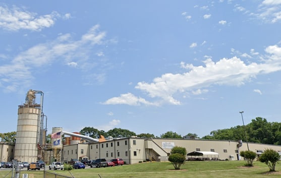
Property Detail
281 Kentucky Rd
044-A2-00-31-0009-0
44A2 BK 31-10B&13A
Commercialnec
Orange
I INDUSTRI
Virginia
B and X Area of moderate flood hazard, usually the area between the limits of the 100-year and 500-year floods.
10-b
2025
17.40 AC
2025
Virginia Regional
110200
Other Market Areas
140,515 SF
Lake of the Woods, VA
NEARBY LISTINGS FOR SALE OR LEASE
-
-
View all Orange listings for sale on LoopNet.com
DEMOGRAPHICS near 281 Kentucky Rd
1 mile
3 mile
5 mile
2025 Total Population
4,754
6,255
9,142
2030 Population
4,980
6,564
9,600
Pop Growth 2025-2030
+ 4.75%
+ 4.94%
+ 5.01%
Average Age
42
42
42
2025 Total Households
1,946
2,547
3,648
HH Growth 2025-2030
+ 4.93%
+ 5.10%
+ 5.15%
Median Household Inc
$71,144
$72,210
$74,147
Avg Household Size
2.40
2.40
2.40
2025 Avg HH Vehicles
2.00
2.00
2.00
Median Home Value
$278,271
$281,853
$290,376
Median Year Built
1982
1982
1983
Nearby Places
Map Layers
Map Styles
 Street
 Aerial
Layers
 Traffic
 Biking
Places
Listings with unknown addresses are not visible on the map
- Restaurants
- Banks
- Shops
- Fitness
- Groceries
PUBLIC TRANSPORTATION
AIRPORT
Charlottesville-Albemarle
Drive
Walk
Distance
Charlottesville-Albemarle
49 min
26.8 mi
SALE & LEASE HISTORY
LISTING DATE
SALE/LEASE

Jan 30, 2025
For Sale
Nearby Properties
Address
Land Use
TOTAL SIZE
Lot Size
Zoning
Address
Land Use
TOTAL SIZE
Lot Size
Zoning
1,830 SF
144.24 AC
A1FP
Address
Land Use
TOTAL SIZE
Lot Size
Zoning
220,613 SF
15.48 AC
RR RURAL R
Address
Land Use
TOTAL SIZE
Lot Size
Zoning
83,804 SF
41 AC
R2 GENERAL
Address
Land Use
TOTAL SIZE
Lot Size
Zoning
84,396 SF
4.50 AC
TAC TOWN A
Address
Land Use
TOTAL SIZE
Lot Size
Zoning
74,742 SF
12.56 AC
GR LEGACY
Address
Land Use
TOTAL SIZE
Lot Size
Zoning
4,240 SF
297.26 AC
A1FP
Address
Land Use
TOTAL SIZE
Lot Size
Zoning
40,230 SF
1.58 AC
C COMMERCI
Address
Land Use
TOTAL SIZE
Lot Size
Zoning
23,833 SF
41.74 AC
R1 LIMITED
Address
Land Use
TOTAL SIZE
Lot Size
Zoning
114,525 SF
11.57 AC
C2 GENERAL
Address
Land Use
TOTAL SIZE
Lot Size
Zoning
25,469 SF
3.35 AC
C2 GENERAL
Address
Land Use
TOTAL SIZE
Lot Size
Zoning
132,796 SF
15.55 AC
I INDUSTRI
Address
Land Use
TOTAL SIZE
Lot Size
Zoning
11,008 SF
4.34 AC
MF MULTIFA
Address
Land Use
TOTAL SIZE
Lot Size
Zoning
44,055 SF
8.30 AC
TAC TOWN A
Address
Land Use
TOTAL SIZE
Lot Size
Zoning
28,160 SF
1.01 AC
C COMMERCI
Address
Land Use
TOTAL SIZE
Lot Size
Zoning
14,614 SF
1.65 AC
C2 GENERAL
Address
Land Use
TOTAL SIZE
Lot Size
Zoning
21,259 SF
2.86 AC
TRH TRAD R
Address
Land Use
TOTAL SIZE
Lot Size
Zoning
42,416 SF
2.07 AC
C2 GENERAL
Address
Land Use
TOTAL SIZE
Lot Size
Zoning
21,259 SF
3.91 AC
TRH TRAD R
Address
Land Use
TOTAL SIZE
Lot Size
Zoning
64,878 SF
9.81 AC
C COMMERCI
Address
Land Use
TOTAL SIZE
Lot Size
Zoning
144,383 SF
5.93 AC
I INDUSTRI
Address
Land Use
TOTAL SIZE
Lot Size
Zoning
1,495 SF
3.37 AC
TRH TRAD R
Address
Land Use
TOTAL SIZE
Lot Size
Zoning
533.52 AC
A AGRICULT
Address
Land Use
TOTAL SIZE
Lot Size
Zoning
15,521 SF
1.93 AC
C2 GENERAL
Address
Land Use
TOTAL SIZE
Lot Size
Zoning
65,232 SF
10.56 AC
C2 GENERAL
Address
Land Use
TOTAL SIZE
Lot Size
Zoning
7,169 SF
0.49 AC
C COMMERCI
Address
Land Use
TOTAL SIZE
Lot Size
Zoning
3,106 SF
212.34 AC
A1FP
Address
Land Use
TOTAL SIZE
Lot Size
Zoning
69,305 SF
10.88 AC
C2 GENERAL
Address
Land Use
TOTAL SIZE
Lot Size
Zoning
428.58 AC
A AGRICULT
Address
Land Use
TOTAL SIZE
Lot Size
Zoning
20,975 SF
2.49 AC
C2 GENERAL
The World's #1 Commercial Real Estate Marketplace
Connect with us
© 2026 CoStar Group
The information above has been obtained from sources believed reliable. While we do not doubt its accuracy we have not verified it and make no guarantee, warranty or representation about it. It is your responsibility to independently confirm its accuracy and completeness. Any projections, opinions, assumptions, or estimates used are for example only and do not represent the current or future performance of the property. The value of this transaction to you depends on tax and other factors which should be evaluated by your tax, financial, and legal advisors. You and your advisors should conduct a careful, independent investigation of the property to determine to your satisfaction the suitability of the property for your needs.