Property Record
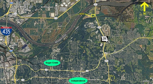
2810 N M 291 Hwy, Sugar Creek, MO 64050

This Property Is For Sale
NEARBY LISTINGS FOR SALE OR LEASE
-
-
View all Sugar Creek listings for sale on LoopNet.com
Property Detail
2810 N M 291 Hwy
11-700-02-22-00-0-00-000
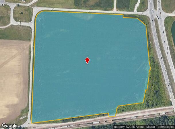
SEC-13 TWP-50 RNG-32---PT NW 1/4 NW 1/4 DAF: BEG NW COR TH S 87 DEG 32 MIN 46 SEC E 947.68 TH S 02 DEG 41 MIN 19 SEC W 54.28 TH S 87 DEG 18 MIN 41 SEC E 150 TH S 49 DEG 57 MIN 0
Agriculturalland
Jackson
AE
Missouri
29095C0167G
32.50 AC
2024
East Jackson County
2025
Kansas City
011502
Kansas City, MO-KS
DEMOGRAPHICS near 2810 N M 291 Hwy
1 Mile
3 Mile
5 Mile
2024 Total Population
48
9,031
50,333
2029 Population
48
8,925
50,322
Pop Growth 2024-2029
0.00%
(1.17%)
(0.02%)
Average Age
42
38
39
2024 Total Households
16
3,314
19,361
HH Growth 2024-2029
0.00%
(1.30%)
(0.13%)
Median Household Inc
$78,125
$64,910
$60,278
Avg Household Size
2.40
2.70
2.50
2024 Avg HH Vehicles
3.00
2.00
2.00
Median Home Value
$181,249
$169,324
$162,148
Median Year Built
1971
1968
1966
Nearby Places
Map Layers
Map Styles
 Street
 Aerial
- Restaurants
- Banks
- Shops
- Fitness
- Groceries
PUBLIC TRANSPORTATION
COMMUTER RAIL
Independence Amtrak Station (Lincoln Service Missouri River Runner - Amtrak, Missouri River Runner - Amtrak)
DRIVE
WALK
Distance
Independence Amtrak Station (Lincoln Service Missouri River Runner - Amtrak, Missouri River Runner - Amtrak)
14 min
6.8 mi
AIRPORT
Kansas City International
DRIVE
WALK
Distance
Kansas City International
36 min
25.8 mi
Freight Ports
Tulsa Port Of Catoosa
DRIVE
WALK
Distance
Tulsa Port Of Catoosa
286 min
255.6 mi
Nearby Properties
Address
Land Use
TOTAL SIZE
Lot Size
Zoning
Address
Land Use
TOTAL SIZE
Lot Size
Zoning
Address
Land Use
TOTAL SIZE
Lot Size
Zoning
96.58 AC
Address
Land Use
TOTAL SIZE
Lot Size
Zoning
84.66 AC
Address
Land Use
TOTAL SIZE
Lot Size
Zoning
23.13 AC
Address
Land Use
TOTAL SIZE
Lot Size
Zoning
20.82 AC
Address
Land Use
TOTAL SIZE
Lot Size
Zoning
68.64 AC
Address
Land Use
TOTAL SIZE
Lot Size
Zoning
22.99 AC
Address
Land Use
TOTAL SIZE
Lot Size
Zoning
21.38 AC
Address
Land Use
TOTAL SIZE
Lot Size
Zoning
108.96 AC
Address
Land Use
TOTAL SIZE
Lot Size
Zoning
1 SF
1.44 AC
Address
Land Use
TOTAL SIZE
Lot Size
Zoning
18,407 SF
28.30 AC
Address
Land Use
TOTAL SIZE
Lot Size
Zoning
Address
Land Use
TOTAL SIZE
Lot Size
Zoning
69.90 AC
Address
Land Use
TOTAL SIZE
Lot Size
Zoning
41.57 AC
Address
Land Use
TOTAL SIZE
Lot Size
Zoning
155,098 SF
94.87 AC
Address
Land Use
TOTAL SIZE
Lot Size
Zoning
89.72 AC
Address
Land Use
TOTAL SIZE
Lot Size
Zoning
Address
Land Use
TOTAL SIZE
Lot Size
Zoning
158,109 SF
2.77 AC
Address
Land Use
TOTAL SIZE
Lot Size
Zoning
33.05 AC
Address
Land Use
TOTAL SIZE
Lot Size
Zoning
223.76 AC
Address
Land Use
TOTAL SIZE
Lot Size
Zoning
7,948 SF
186.06 AC
Address
Land Use
TOTAL SIZE
Lot Size
Zoning
Address
Land Use
TOTAL SIZE
Lot Size
Zoning
63.19 AC
Address
Land Use
TOTAL SIZE
Lot Size
Zoning
Address
Land Use
TOTAL SIZE
Lot Size
Zoning
Address
Land Use
TOTAL SIZE
Lot Size
Zoning
4,200,000 SF
0.66 AC
Address
Land Use
TOTAL SIZE
Lot Size
Zoning
97,385 SF
1.70 AC
Address
Land Use
TOTAL SIZE
Lot Size
Zoning
10.54 AC
Address
Land Use
TOTAL SIZE
Lot Size
Zoning
15,015 SF
1.96 AC
Address
Land Use
TOTAL SIZE
Lot Size
Zoning
1.65 AC
The World's #1 Commercial Real Estate Marketplace
Connect with us
© 2025 CoStar Group
The information above has been obtained from sources believed reliable. While we do not doubt its accuracy we have not verified it and make no guarantee, warranty or representation about it. It is your responsibility to independently confirm its accuracy and completeness. Any projections, opinions, assumptions, or estimates used are for example only and do not represent the current or future performance of the property. The value of this transaction to you depends on tax and other factors which should be evaluated by your tax, financial, and legal advisors. You and your advisors should conduct a careful, independent investigation of the property to determine to your satisfaction the suitability of the property for your needs.