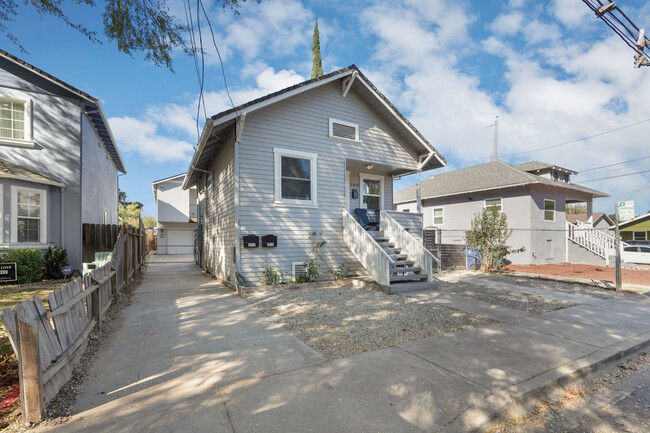
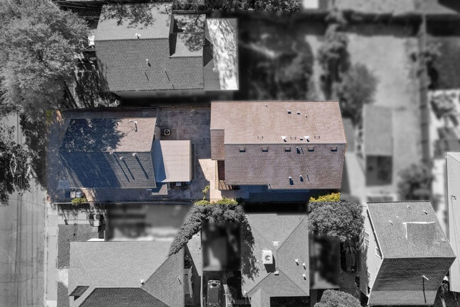
Property Record
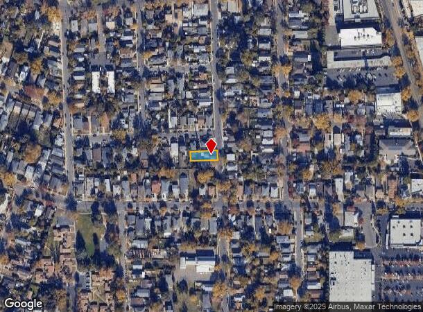
2810 42Nd St, Sacramento, CA 95817
NEARBY LISTINGS FOR SALE OR LEASE
Property Detail
2810 42Nd St
Sacramento--Roseville--Arden-Arcade, CA
Venado Place
014-0114-002
Sacramento
Sfr
California
X
0.11 AC
06067C0190H
North Oak Park
2,380 SF
Sacramento
DEMOGRAPHICS near 2810 42Nd St
1 Mile
3 Mile
5 Mile
2024 Total Population
22,237
182,164
423,304
2029 Population
22,527
184,719
427,880
Pop Growth 2024-2029
+ 1.30%
+ 1.40%
+ 1.08%
Average Age
38
39
38
2024 Total Households
9,314
77,109
163,163
HH Growth 2024-2029
+ 1.29%
+ 1.66%
+ 1.32%
Median Household Inc
$62,448
$72,851
$66,043
Avg Household Size
2.20
2.20
2.40
2024 Avg HH Vehicles
2.00
2.00
2.00
Median Home Value
$455,697
$545,303
$453,199
Median Year Built
1954
1956
1966
Nearby Places
Map Layers
Map Styles
 Street
 Aerial
- Restaurants
- Banks
- Shops
- Fitness
- Groceries
PUBLIC TRANSPORTATION
TRANSIT/SUBWAY
39Th Street (Gold Line - Sacramento Regional Transit District Light Rail (The RT))
DRIVE
WALK
Distance
39Th Street (Gold Line - Sacramento Regional Transit District Light Rail (The RT))
3 min
18 min
1.0 mi
COMMUTER RAIL
Sacramento (Capitol Corridor - Capitol Corridor Joint Powers Authority)
DRIVE
WALK
Distance
Sacramento (Capitol Corridor - Capitol Corridor Joint Powers Authority)
9 min
4.7 mi
AIRPORT
Sacramento International
DRIVE
WALK
Distance
Sacramento International
23 min
15.6 mi
Freight Ports
Port of Stockton
DRIVE
WALK
Distance
Port of Stockton
57 min
47.0 mi
SALE & LEASE HISTORY
LISTING DATE
SALE/LEASE

Nov 02, 2024
For Sale
Nearby Properties
Address
Land Use
TOTAL SIZE
Lot Size
Zoning
Address
Land Use
TOTAL SIZE
Lot Size
Zoning
1,095,507 SF
1.39 AC
H-SPD C-2-
Address
Land Use
TOTAL SIZE
Lot Size
Zoning
10.28 AC
H
Address
Land Use
TOTAL SIZE
Lot Size
Zoning
299,943 SF
4.95 AC
H
Address
Land Use
TOTAL SIZE
Lot Size
Zoning
1.33 AC
R-1
Address
Land Use
TOTAL SIZE
Lot Size
Zoning
756,831 SF
1.39 AC
C-2-SPD
Address
Land Use
TOTAL SIZE
Lot Size
Zoning
9.29 AC
R-1 OB-R-P
Address
Land Use
TOTAL SIZE
Lot Size
Zoning
1.15 AC
R-1
Address
Land Use
TOTAL SIZE
Lot Size
Zoning
366,730 SF
0.89 AC
C-3-SPD
Address
Land Use
TOTAL SIZE
Lot Size
Zoning
200,616 SF
2.54 AC
C-2-SPD
Address
Land Use
TOTAL SIZE
Lot Size
Zoning
31,163 SF
1.57 AC
C-2-TO-SPD
Address
Land Use
TOTAL SIZE
Lot Size
Zoning
350,049 SF
8.51 AC
MRD-SWR
Address
Land Use
TOTAL SIZE
Lot Size
Zoning
339,329 SF
6.40 AC
R-5-PUD-SP
Address
Land Use
TOTAL SIZE
Lot Size
Zoning
281,448 SF
13.42 AC
RMX-TO R-2
Address
Land Use
TOTAL SIZE
Lot Size
Zoning
0.65 AC
C-4-SPD
Address
Land Use
TOTAL SIZE
Lot Size
Zoning
410,420 SF
0.95 AC
C-3-SPD
Address
Land Use
TOTAL SIZE
Lot Size
Zoning
320,072 SF
2.65 AC
C-2
Address
Land Use
TOTAL SIZE
Lot Size
Zoning
508,916 SF
0.71 AC
C-3-SPD
Address
Land Use
TOTAL SIZE
Lot Size
Zoning
246,417 SF
1.19 AC
C-3-SPD
Address
Land Use
TOTAL SIZE
Lot Size
Zoning
119,055 SF
1.18 AC
C-2-SPD
Address
Land Use
TOTAL SIZE
Lot Size
Zoning
383,000 SF
25.52 AC
M-1
Address
Land Use
TOTAL SIZE
Lot Size
Zoning
576,291 SF
C-3-SPD
Address
Land Use
TOTAL SIZE
Lot Size
Zoning
179,178 SF
3.35 AC
RO
Address
Land Use
TOTAL SIZE
Lot Size
Zoning
2.59 AC
OB-R
Address
Land Use
TOTAL SIZE
Lot Size
Zoning
122,425 SF
0.59 AC
C-2-SPD
Address
Land Use
TOTAL SIZE
Lot Size
Zoning
926 SF
0.07 AC
C-2-SPD
Address
Land Use
TOTAL SIZE
Lot Size
Zoning
240,548 SF
0.86 AC
C-3-SPD
Address
Land Use
TOTAL SIZE
Lot Size
Zoning
0.66 AC
C-3-SPD
Address
Land Use
TOTAL SIZE
Lot Size
Zoning
1.15 AC
R-1
Address
Land Use
TOTAL SIZE
Lot Size
Zoning
171,926 SF
0.34 AC
C-3-SPD
Address
Land Use
TOTAL SIZE
Lot Size
Zoning
156,462 SF
8.36 AC
R-3
The World's #1 Commercial Real Estate Marketplace
Connect with us
© 2025 CoStar Group
The information above has been obtained from sources believed reliable. While we do not doubt its accuracy we have not verified it and make no guarantee, warranty or representation about it. It is your responsibility to independently confirm its accuracy and completeness. Any projections, opinions, assumptions, or estimates used are for example only and do not represent the current or future performance of the property. The value of this transaction to you depends on tax and other factors which should be evaluated by your tax, financial, and legal advisors. You and your advisors should conduct a careful, independent investigation of the property to determine to your satisfaction the suitability of the property for your needs.