Property Record
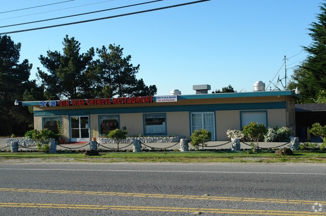
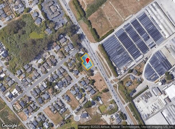
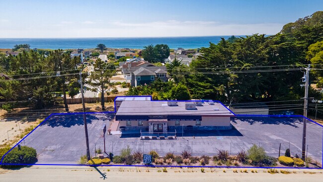
2810 Cabrillo Hwy N, Half Moon Bay, CA 94019

NEARBY LISTINGS FOR SALE OR LEASE
Property Detail
2810 Cabrillo Hwy N
San Francisco-Redwood City-South San Francisco, CA
Map Of City Of Naples
048-124-120
LOTS 10 11 12 13 14 & 15 BLOCK 13 LESS PTN TO HWY CITY OFNAPLES RSM 5/30
Storebuilding
San Mateo
X
California
06081C0252F
10
2024
0.33 AC
2025
Peninsula Coastline
613502
San Francisco
DEMOGRAPHICS near 2810 Cabrillo Hwy N
1 Mile
3 Mile
5 Mile
2024 Total Population
2,489
14,260
20,436
2029 Population
2,337
13,302
18,954
Pop Growth 2024-2029
(6.11%)
(6.72%)
(7.25%)
Average Age
45
44
46
2024 Total Households
892
5,160
7,601
HH Growth 2024-2029
(6.50%)
(7.09%)
(7.55%)
Median Household Inc
$153,873
$137,459
$145,341
Avg Household Size
2.70
2.60
2.60
2024 Avg HH Vehicles
2.00
2.00
2.00
Median Home Value
$1,131,826
$1,111,942
$1,116,125
Median Year Built
1980
1978
1979
Nearby Places
Map Layers
Map Styles
 Street
 Aerial
- Restaurants
- Banks
- Shops
- Fitness
- Groceries
PUBLIC TRANSPORTATION
AIRPORT
San Francisco International
DRIVE
WALK
Distance
San Francisco International
34 min
19.3 mi
Metro Oakland International
DRIVE
WALK
Distance
Metro Oakland International
54 min
38.4 mi
Norman Y Mineta San Jose International
DRIVE
WALK
Distance
Norman Y Mineta San Jose International
55 min
39.7 mi
Freight Ports
Port of Redwood City
DRIVE
WALK
Distance
Port of Redwood City
35 min
22.5 mi
SALE & LEASE HISTORY
LISTING DATE
SALE/LEASE

Nov 08, 2021
For Lease
Nearby Properties
Address
Land Use
TOTAL SIZE
Lot Size
Zoning
Address
Land Use
TOTAL SIZE
Lot Size
Zoning
94,688 SF
3.54 AC
H10000
Address
Land Use
TOTAL SIZE
Lot Size
Zoning
4.86 AC
Address
Land Use
TOTAL SIZE
Lot Size
Zoning
33,500 SF
3.23 AC
CH0000
Address
Land Use
TOTAL SIZE
Lot Size
Zoning
295,300 SF
2.90 AC
CH0000
Address
Land Use
TOTAL SIZE
Lot Size
Zoning
Address
Land Use
TOTAL SIZE
Lot Size
Zoning
20.61 AC
Address
Land Use
TOTAL SIZE
Lot Size
Zoning
2.17 AC
CH0000
Address
Land Use
TOTAL SIZE
Lot Size
Zoning
164.23 AC
RM0000
Address
Land Use
TOTAL SIZE
Lot Size
Zoning
2,014 SF
1.40 AC
Address
Land Use
TOTAL SIZE
Lot Size
Zoning
Address
Land Use
TOTAL SIZE
Lot Size
Zoning
18,075 SF
1.65 AC
C200R2
Address
Land Use
TOTAL SIZE
Lot Size
Zoning
1.65 AC
CH00C2
Address
Land Use
TOTAL SIZE
Lot Size
Zoning
15,724 SF
0.37 AC
R300S3
Address
Land Use
TOTAL SIZE
Lot Size
Zoning
31,437 SF
1.89 AC
Address
Land Use
TOTAL SIZE
Lot Size
Zoning
2.09 AC
Address
Land Use
TOTAL SIZE
Lot Size
Zoning
Address
Land Use
TOTAL SIZE
Lot Size
Zoning
10,883 SF
0.25 AC
R20000
Address
Land Use
TOTAL SIZE
Lot Size
Zoning
24,275 SF
1.74 AC
Address
Land Use
TOTAL SIZE
Lot Size
Zoning
38,620 SF
3.62 AC
C20000
Address
Land Use
TOTAL SIZE
Lot Size
Zoning
5,290 SF
0.31 AC
R300S
Address
Land Use
TOTAL SIZE
Lot Size
Zoning
860 SF
0.23 AC
R30000
Address
Land Use
TOTAL SIZE
Lot Size
Zoning
15,764 SF
1.08 AC
CH0000
Address
Land Use
TOTAL SIZE
Lot Size
Zoning
2.23 AC
ML00M1
Address
Land Use
TOTAL SIZE
Lot Size
Zoning
Address
Land Use
TOTAL SIZE
Lot Size
Zoning
1.29 AC
C200R2
Address
Land Use
TOTAL SIZE
Lot Size
Zoning
12,675 SF
0.60 AC
Address
Land Use
TOTAL SIZE
Lot Size
Zoning
13,912 SF
0.41 AC
R30000
Address
Land Use
TOTAL SIZE
Lot Size
Zoning
0.12 AC
Address
Land Use
TOTAL SIZE
Lot Size
Zoning
10,295 SF
0.17 AC
CH00C2
The World's #1 Commercial Real Estate Marketplace
Connect with us
© 2025 CoStar Group
The information above has been obtained from sources believed reliable. While we do not doubt its accuracy we have not verified it and make no guarantee, warranty or representation about it. It is your responsibility to independently confirm its accuracy and completeness. Any projections, opinions, assumptions, or estimates used are for example only and do not represent the current or future performance of the property. The value of this transaction to you depends on tax and other factors which should be evaluated by your tax, financial, and legal advisors. You and your advisors should conduct a careful, independent investigation of the property to determine to your satisfaction the suitability of the property for your needs.