Property Record
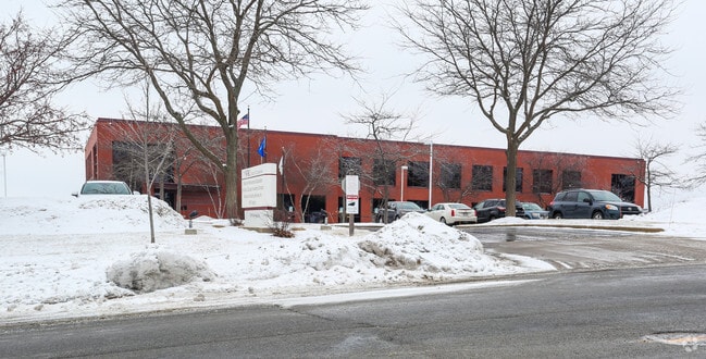
2810 City View Dr, Madison, WI 53718


NEARBY LISTINGS FOR SALE OR LEASE
Property Detail
2810 City View Dr
Madison, WI
High Crossing First Addition
0810-271-0309-3
HIGH CROSSING FIRST ADDITION, LOTS 32, 33 & 34
Commercialnec
Dane
X
Wisconsin
55025C0268H
32
2024
4.52 AC
2024
Northeast Madison
011405
Milwaukee/Madison
36,778 SF
DEMOGRAPHICS near 2810 City View Dr
1 Mile
3 Mile
5 Mile
2024 Total Population
5,755
37,011
121,573
2029 Population
6,073
38,583
126,445
Pop Growth 2024-2029
+ 5.53%
+ 4.25%
+ 4.01%
Average Age
37
38
40
2024 Total Households
2,769
16,404
54,234
HH Growth 2024-2029
+ 5.63%
+ 4.36%
+ 4.10%
Median Household Inc
$69,173
$71,712
$73,263
Avg Household Size
2.00
2.20
2.20
2024 Avg HH Vehicles
2.00
2.00
2.00
Median Home Value
$235,285
$265,242
$278,231
Median Year Built
1996
1994
1980
Nearby Places
Map Layers
Map Styles
 Street
 Aerial
- Restaurants
- Banks
- Shops
- Fitness
- Groceries
PUBLIC TRANSPORTATION
AIRPORT
Dane County Regional/Truax Field
DRIVE
WALK
Distance
Dane County Regional/Truax Field
13 min
5.6 mi
SALE & LEASE HISTORY
LISTING DATE
SALE/LEASE

Mar 04, 2024
For Sale
Nearby Properties
Address
Land Use
TOTAL SIZE
Lot Size
Zoning
Address
Land Use
TOTAL SIZE
Lot Size
Zoning
27.70 AC
SEC
Address
Land Use
TOTAL SIZE
Lot Size
Zoning
509,946 SF
40.17 AC
IL
Address
Land Use
TOTAL SIZE
Lot Size
Zoning
81,771 SF
7.76 AC
CC-T
Address
Land Use
TOTAL SIZE
Lot Size
Zoning
344,415 SF
7.45 AC
SEC
Address
Land Use
TOTAL SIZE
Lot Size
Zoning
385,400 SF
62.07 AC
IL
Address
Land Use
TOTAL SIZE
Lot Size
Zoning
8.49 AC
SFR
Address
Land Use
TOTAL SIZE
Lot Size
Zoning
289,884 SF
19.36 AC
SR-V2
Address
Land Use
TOTAL SIZE
Lot Size
Zoning
107,751 SF
22.34 AC
IL
Address
Land Use
TOTAL SIZE
Lot Size
Zoning
921,697 SF
24.28 AC
SEC
Address
Land Use
TOTAL SIZE
Lot Size
Zoning
97,580 SF
6.86 AC
TR-U1
Address
Land Use
TOTAL SIZE
Lot Size
Zoning
357,427 SF
12.77 AC
PD
Address
Land Use
TOTAL SIZE
Lot Size
Zoning
372,177 SF
19.47 AC
SR-V2
Address
Land Use
TOTAL SIZE
Lot Size
Zoning
1,318,936 SF
25.96 AC
SEC
Address
Land Use
TOTAL SIZE
Lot Size
Zoning
8.56 AC
Address
Land Use
TOTAL SIZE
Lot Size
Zoning
294,106 SF
29.06 AC
CC
Address
Land Use
TOTAL SIZE
Lot Size
Zoning
1,322 SF
59.57 AC
SEC
Address
Land Use
TOTAL SIZE
Lot Size
Zoning
104,000 SF
11.21 AC
CC-T
Address
Land Use
TOTAL SIZE
Lot Size
Zoning
46,902 SF
5.28 AC
PD
Address
Land Use
TOTAL SIZE
Lot Size
Zoning
222,532 SF
18.02 AC
PD
Address
Land Use
TOTAL SIZE
Lot Size
Zoning
327,302 SF
8.24 AC
PD
Address
Land Use
TOTAL SIZE
Lot Size
Zoning
316,954 SF
24.96 AC
SEC
Address
Land Use
TOTAL SIZE
Lot Size
Zoning
3.03 AC
RH-35
Address
Land Use
TOTAL SIZE
Lot Size
Zoning
101,348 SF
6.37 AC
SEC
Address
Land Use
TOTAL SIZE
Lot Size
Zoning
4,542 SF
10.01 AC
PD
Address
Land Use
TOTAL SIZE
Lot Size
Zoning
6.76 AC
SEC
Address
Land Use
TOTAL SIZE
Lot Size
Zoning
167,519 SF
4.51 AC
PD
Address
Land Use
TOTAL SIZE
Lot Size
Zoning
105,743 SF
9.50 AC
IG
Address
Land Use
TOTAL SIZE
Lot Size
Zoning
64,900 SF
4.21 AC
PD
Address
Land Use
TOTAL SIZE
Lot Size
Zoning
11.48 AC
SEC
Address
Land Use
TOTAL SIZE
Lot Size
Zoning
37,133 SF
4.71 AC
CC-T
The World's #1 Commercial Real Estate Marketplace
Connect with us
© 2026 CoStar Group
The information above has been obtained from sources believed reliable. While we do not doubt its accuracy we have not verified it and make no guarantee, warranty or representation about it. It is your responsibility to independently confirm its accuracy and completeness. Any projections, opinions, assumptions, or estimates used are for example only and do not represent the current or future performance of the property. The value of this transaction to you depends on tax and other factors which should be evaluated by your tax, financial, and legal advisors. You and your advisors should conduct a careful, independent investigation of the property to determine to your satisfaction the suitability of the property for your needs.