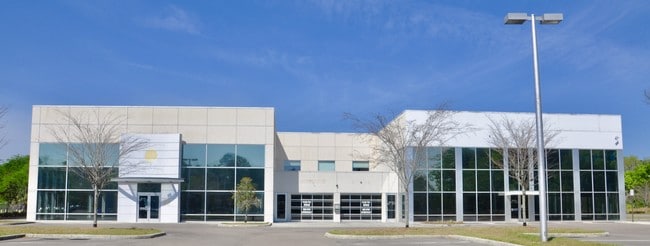
Property Record
2810 N Main St, Gainesville, FL 32609

Property Detail
2810 N Main St
08243-002-000
COM NW COR OF SW1/4 SEC S 500.97 FT POB E 941.01 FT TO W R/W OF SR 329 S/LY 751.59 FT W/LY 35.0 FT SLY 87.68 FT W 807.22 FT N 823 M/L TO POB DB 358/235 OR 619/152 OR 619/158 OR 671/396 LESS 3.91 ACRE PARCEL PER OR 1236/649 & LESS R/W PER OR 1238/376)
Vehiclerentalsvehiclesales
Alachua
I1
Florida
A Areas with a 1% annual chance of flooding and a 26% chance of flooding over the life of a 30-year mortgage.
12.03 AC
2025
Northwest Gainesville
2025
Other Market Areas
000302
Gainesville, FL
39,980 SF
NEARBY LISTINGS FOR SALE OR LEASE
DEMOGRAPHICS near 2810 N Main St
1 mile
3 mile
5 mile
2025 Total Population
7,114
65,720
137,637
2030 Population
7,335
67,744
142,181
Pop Growth 2025-2030
+ 3.11%
+ 3.08%
+ 3.30%
Average Age
38
34
35
2025 Total Households
3,253
25,888
55,329
HH Growth 2025-2030
+ 3.57%
+ 3.74%
+ 3.79%
Median Household Inc
$54,734
$43,885
$50,257
Avg Household Size
2.10
2.10
2.10
2025 Avg HH Vehicles
1.00
1.00
2.00
Median Home Value
$175,045
$235,804
$263,914
Median Year Built
1971
1976
1980
Nearby Places
Map Layers
Map Styles
 Street
 Aerial
Layers
 Traffic
 Biking
Places
Listings with unknown addresses are not visible on the map
- Restaurants
- Banks
- Shops
- Fitness
- Groceries
PUBLIC TRANSPORTATION
AIRPORT
Gainesville Regional
Drive
Walk
Distance
Gainesville Regional
12 min
4.3 mi
Freight Ports
Jacksonville Port
Drive
Walk
Distance
Jacksonville Port
97 min
74.1 mi
SALE & LEASE HISTORY
LISTING DATE
SALE/LEASE

Apr 03, 2017
For Sale
Nearby Properties
Address
Land Use
TOTAL SIZE
Lot Size
Zoning
Address
Land Use
TOTAL SIZE
Lot Size
Zoning
108,640 SF
20 AC
ED
Address
Land Use
TOTAL SIZE
Lot Size
Zoning
17.87 AC
ED
Address
Land Use
TOTAL SIZE
Lot Size
Zoning
430,590 SF
16.95 AC
ED
Address
Land Use
TOTAL SIZE
Lot Size
Zoning
682,400 SF
20 AC
ED
Address
Land Use
TOTAL SIZE
Lot Size
Zoning
959,910 SF
2.50 AC
PD
Address
Land Use
TOTAL SIZE
Lot Size
Zoning
399,130 SF
18.13 AC
ED
Address
Land Use
TOTAL SIZE
Lot Size
Zoning
416,200 SF
20 AC
ED
Address
Land Use
TOTAL SIZE
Lot Size
Zoning
334,819 SF
1.79 AC
U9
Address
Land Use
TOTAL SIZE
Lot Size
Zoning
325,519 SF
1.25 AC
U8
Address
Land Use
TOTAL SIZE
Lot Size
Zoning
582,311 SF
20 AC
ED
Address
Land Use
TOTAL SIZE
Lot Size
Zoning
372,990 SF
20 AC
ED
Address
Land Use
TOTAL SIZE
Lot Size
Zoning
357,020 SF
20 AC
ED
Address
Land Use
TOTAL SIZE
Lot Size
Zoning
25.64 AC
PS
Address
Land Use
TOTAL SIZE
Lot Size
Zoning
594,946 SF
4.47 AC
DT
Address
Land Use
TOTAL SIZE
Lot Size
Zoning
271,079 SF
0.94 AC
PD
Address
Land Use
TOTAL SIZE
Lot Size
Zoning
279,647 SF
1.66 AC
PD
Address
Land Use
TOTAL SIZE
Lot Size
Zoning
117,563 SF
1.61 AC
U8
Address
Land Use
TOTAL SIZE
Lot Size
Zoning
362,539 SF
2.11 AC
U8
Address
Land Use
TOTAL SIZE
Lot Size
Zoning
414,780 SF
1.99 AC
PD
Address
Land Use
TOTAL SIZE
Lot Size
Zoning
299,737 SF
1.14 AC
DT
Address
Land Use
TOTAL SIZE
Lot Size
Zoning
94,156 SF
3.65 AC
U9
Address
Land Use
TOTAL SIZE
Lot Size
Zoning
295,990 SF
20 AC
ED
Address
Land Use
TOTAL SIZE
Lot Size
Zoning
280,840 SF
20 AC
ED
Address
Land Use
TOTAL SIZE
Lot Size
Zoning
404,722 SF
2.82 AC
U6
Address
Land Use
TOTAL SIZE
Lot Size
Zoning
444,350 SF
4.38 AC
DT
Address
Land Use
TOTAL SIZE
Lot Size
Zoning
1,331,605 SF
32.61 AC
ED
Address
Land Use
TOTAL SIZE
Lot Size
Zoning
395,561 SF
19.11 AC
PD
Address
Land Use
TOTAL SIZE
Lot Size
Zoning
288,650 SF
20 AC
ED
Address
Land Use
TOTAL SIZE
Lot Size
Zoning
60,480 SF
117.68 AC
PS
Address
Land Use
TOTAL SIZE
Lot Size
Zoning
346,154 SF
22.02 AC
U6
The World's #1 Commercial Real Estate Marketplace
Connect with us
© 2026 CoStar Group
The information above has been obtained from sources believed reliable. While we do not doubt its accuracy we have not verified it and make no guarantee, warranty or representation about it. It is your responsibility to independently confirm its accuracy and completeness. Any projections, opinions, assumptions, or estimates used are for example only and do not represent the current or future performance of the property. The value of this transaction to you depends on tax and other factors which should be evaluated by your tax, financial, and legal advisors. You and your advisors should conduct a careful, independent investigation of the property to determine to your satisfaction the suitability of the property for your needs.