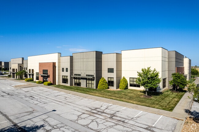
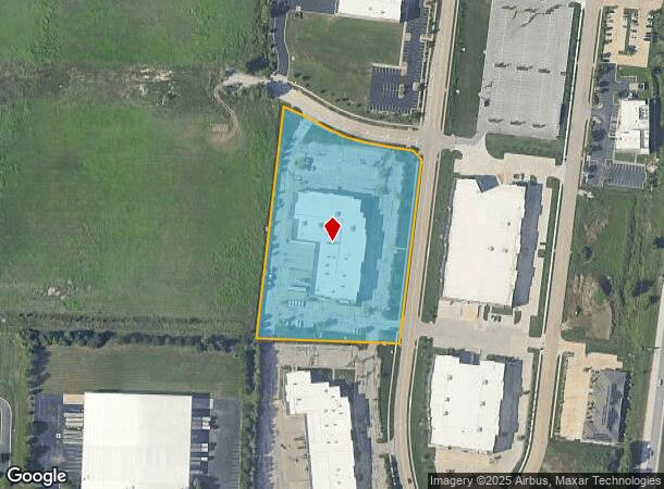
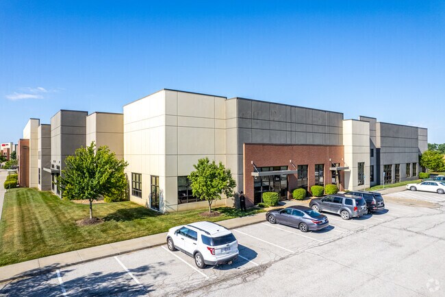
Property Record
2810 Ne Independence Ave, Lees Summit, MO 64064
Current Lease Availabilities
NEARBY LISTINGS FOR SALE OR LEASE
Property Detail
2810 Ne Independence Ave
Kansas City, MO-KS
Lakewood Business Center On I-470
52-200-01-28-00-0-00-000
LAKEWOOD BUSINESS CENTER ON I-470 - PLAT P---LOT 19
Warehouse
Jackson
X
Missouri
29095C0430G
19
2024
5.32 AC
2025
Lee's Summit
014205
Kansas City
50,052 SF
DEMOGRAPHICS near 2810 Ne Independence Ave
1 Mile
3 Mile
5 Mile
2024 Total Population
1,111
29,753
94,352
2029 Population
1,108
29,554
93,690
Pop Growth 2024-2029
(0.27%)
(0.67%)
(0.70%)
Average Age
40
40
41
2024 Total Households
435
11,559
37,191
HH Growth 2024-2029
0.00%
(0.68%)
(0.73%)
Median Household Inc
$63,194
$95,716
$92,400
Avg Household Size
2.30
2.50
2.50
2024 Avg HH Vehicles
2.00
2.00
2.00
Median Home Value
$232,692
$281,625
$265,678
Median Year Built
1995
1990
1988
Nearby Places
- Restaurants
- Banks
- Shops
- Fitness
- Groceries
PUBLIC TRANSPORTATION
COMMUTER RAIL
Lee's Summit Amtrak (Lincoln Service Missouri River Runner - Amtrak, Missouri River Runner - Amtrak)
DRIVE
WALK
Distance
Lee's Summit Amtrak (Lincoln Service Missouri River Runner - Amtrak, Missouri River Runner - Amtrak)
11 min
5.3 mi
AIRPORT
Kansas City International
DRIVE
WALK
Distance
Kansas City International
54 min
40.0 mi
Freight Ports
Tulsa Port Of Catoosa
DRIVE
WALK
Distance
Tulsa Port Of Catoosa
269 min
242.6 mi
Nearby Properties
Address
Land Use
TOTAL SIZE
Lot Size
Zoning
Address
Land Use
TOTAL SIZE
Lot Size
Zoning
474,121 SF
40.14 AC
Address
Land Use
TOTAL SIZE
Lot Size
Zoning
535,500 SF
54.13 AC
Address
Land Use
TOTAL SIZE
Lot Size
Zoning
480,000 SF
45.89 AC
Address
Land Use
TOTAL SIZE
Lot Size
Zoning
246,379 SF
51.99 AC
Address
Land Use
TOTAL SIZE
Lot Size
Zoning
438,125 SF
Address
Land Use
TOTAL SIZE
Lot Size
Zoning
195,589 SF
47.72 AC
Address
Land Use
TOTAL SIZE
Lot Size
Zoning
523,783 SF
1.61 AC
Address
Land Use
TOTAL SIZE
Lot Size
Zoning
52,030 SF
11.81 AC
Address
Land Use
TOTAL SIZE
Lot Size
Zoning
227,052 SF
12.78 AC
Address
Land Use
TOTAL SIZE
Lot Size
Zoning
104,368 SF
13.90 AC
Address
Land Use
TOTAL SIZE
Lot Size
Zoning
248,600 SF
Address
Land Use
TOTAL SIZE
Lot Size
Zoning
140,377 SF
27 AC
Address
Land Use
TOTAL SIZE
Lot Size
Zoning
96,980 SF
66.45 AC
Address
Land Use
TOTAL SIZE
Lot Size
Zoning
136,224 SF
15.25 AC
Address
Land Use
TOTAL SIZE
Lot Size
Zoning
104,704 SF
11.28 AC
Address
Land Use
TOTAL SIZE
Lot Size
Zoning
126,081 SF
21 AC
Address
Land Use
TOTAL SIZE
Lot Size
Zoning
192,014 SF
20.95 AC
Address
Land Use
TOTAL SIZE
Lot Size
Zoning
108,530 SF
17.95 AC
Address
Land Use
TOTAL SIZE
Lot Size
Zoning
82,704 SF
148.69 AC
Address
Land Use
TOTAL SIZE
Lot Size
Zoning
125,609 SF
9.32 AC
Address
Land Use
TOTAL SIZE
Lot Size
Zoning
128,393 SF
27.30 AC
Address
Land Use
TOTAL SIZE
Lot Size
Zoning
59,820 SF
6.22 AC
Address
Land Use
TOTAL SIZE
Lot Size
Zoning
251,085 SF
Address
Land Use
TOTAL SIZE
Lot Size
Zoning
12,788 SF
16.29 AC
Address
Land Use
TOTAL SIZE
Lot Size
Zoning
94,314 SF
20.02 AC
Address
Land Use
TOTAL SIZE
Lot Size
Zoning
22,500 SF
Address
Land Use
TOTAL SIZE
Lot Size
Zoning
33,136 SF
3.99 AC
Address
Land Use
TOTAL SIZE
Lot Size
Zoning
115,398 SF
14.52 AC
Address
Land Use
TOTAL SIZE
Lot Size
Zoning
67,800 SF
2.53 AC
Address
Land Use
TOTAL SIZE
Lot Size
Zoning
40,902 SF
8.69 AC
The World's #1 Commercial Real Estate Marketplace
Connect with us
© 2025 CoStar Group
The information above has been obtained from sources believed reliable. While we do not doubt its accuracy we have not verified it and make no guarantee, warranty or representation about it. It is your responsibility to independently confirm its accuracy and completeness. Any projections, opinions, assumptions, or estimates used are for example only and do not represent the current or future performance of the property. The value of this transaction to you depends on tax and other factors which should be evaluated by your tax, financial, and legal advisors. You and your advisors should conduct a careful, independent investigation of the property to determine to your satisfaction the suitability of the property for your needs.