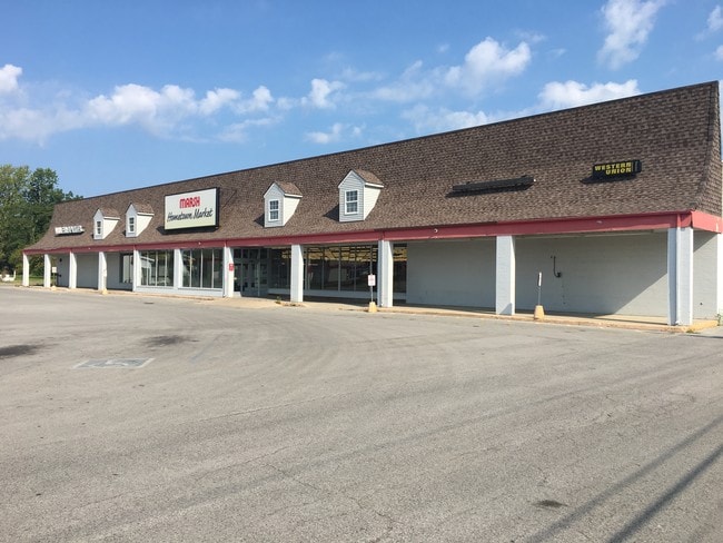
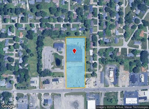
Property Record
2810 Nichol Ave, Anderson, IN 46011
NEARBY LISTINGS FOR SALE OR LEASE
Property Detail
2810 Nichol Ave
48-11-15-102-005.000-003
PT NW NE PLAT 56-1 3.5000ACRES STR: 15197 SECTION: PLAT: 00 IN: OUT:
Supermarket
Madison
X
Indiana
18095C0252D
3.50 AC
2024
Anderson/Madison Cnty
2025
Indianapolis
001700
Indianapolis-Carmel-Anderson, IN
39,479 SF
DEMOGRAPHICS near 2810 Nichol Ave
1 Mile
3 Mile
5 Mile
2024 Total Population
7,103
41,132
67,912
2029 Population
7,373
42,734
70,174
Pop Growth 2024-2029
+ 3.80%
+ 3.89%
+ 3.33%
Average Age
40
40
41
2024 Total Households
2,842
16,987
28,818
HH Growth 2024-2029
+ 3.84%
+ 4.06%
+ 3.45%
Median Household Inc
$46,957
$44,479
$46,317
Avg Household Size
2.40
2.30
2.20
2024 Avg HH Vehicles
2.00
2.00
2.00
Median Home Value
$114,201
$95,452
$111,210
Median Year Built
1958
1956
1960
Nearby Places
- Restaurants
- Banks
- Shops
- Fitness
- Groceries
SALE & LEASE HISTORY
LISTING DATE
SALE/LEASE

Jan 29, 2018
For Lease
Jan 29, 2018
For Sale
Aug 02, 2019
For Lease
Aug 02, 2019
For Sale
Nearby Properties
Address
Land Use
TOTAL SIZE
Lot Size
Zoning
Address
Land Use
TOTAL SIZE
Lot Size
Zoning
75,580 SF
21 AC
Address
Land Use
TOTAL SIZE
Lot Size
Zoning
28,980 SF
9 AC
Address
Land Use
TOTAL SIZE
Lot Size
Zoning
19,855 SF
10.64 AC
Address
Land Use
TOTAL SIZE
Lot Size
Zoning
1,431 SF
17.23 AC
Address
Land Use
TOTAL SIZE
Lot Size
Zoning
36,120 SF
22.78 AC
Address
Land Use
TOTAL SIZE
Lot Size
Zoning
148,490 SF
26 AC
Address
Land Use
TOTAL SIZE
Lot Size
Zoning
122,860 SF
20.24 AC
Address
Land Use
TOTAL SIZE
Lot Size
Zoning
49,033 SF
2.08 AC
Address
Land Use
TOTAL SIZE
Lot Size
Zoning
59,160 SF
59.78 AC
Address
Land Use
TOTAL SIZE
Lot Size
Zoning
13,032 SF
12.58 AC
Address
Land Use
TOTAL SIZE
Lot Size
Zoning
70,860 SF
0.25 AC
Address
Land Use
TOTAL SIZE
Lot Size
Zoning
79,422 SF
5.37 AC
Address
Land Use
TOTAL SIZE
Lot Size
Zoning
34,402 SF
5.85 AC
Address
Land Use
TOTAL SIZE
Lot Size
Zoning
7,566 SF
6.15 AC
Address
Land Use
TOTAL SIZE
Lot Size
Zoning
44,107 SF
5 AC
Address
Land Use
TOTAL SIZE
Lot Size
Zoning
2,936 SF
10.52 AC
Address
Land Use
TOTAL SIZE
Lot Size
Zoning
57,535 SF
4.18 AC
Address
Land Use
TOTAL SIZE
Lot Size
Zoning
35,734 SF
0.71 AC
Address
Land Use
TOTAL SIZE
Lot Size
Zoning
31,000 SF
17.65 AC
Address
Land Use
TOTAL SIZE
Lot Size
Zoning
31,214 SF
0.19 AC
Address
Land Use
TOTAL SIZE
Lot Size
Zoning
97,910 SF
2.80 AC
Address
Land Use
TOTAL SIZE
Lot Size
Zoning
421,323 SF
8.13 AC
Address
Land Use
TOTAL SIZE
Lot Size
Zoning
10,664 SF
8.53 AC
Address
Land Use
TOTAL SIZE
Lot Size
Zoning
44,891 SF
Address
Land Use
TOTAL SIZE
Lot Size
Zoning
3,510 SF
78.56 AC
Address
Land Use
TOTAL SIZE
Lot Size
Zoning
39,166 SF
7.50 AC
Address
Land Use
TOTAL SIZE
Lot Size
Zoning
49,536 SF
Address
Land Use
TOTAL SIZE
Lot Size
Zoning
131,853 SF
1.03 AC
Address
Land Use
TOTAL SIZE
Lot Size
Zoning
10,664 SF
6.17 AC
Address
Land Use
TOTAL SIZE
Lot Size
Zoning
23,834 SF
3.69 AC
The World's #1 Commercial Real Estate Marketplace
Connect with us
© 2025 CoStar Group
The information above has been obtained from sources believed reliable. While we do not doubt its accuracy we have not verified it and make no guarantee, warranty or representation about it. It is your responsibility to independently confirm its accuracy and completeness. Any projections, opinions, assumptions, or estimates used are for example only and do not represent the current or future performance of the property. The value of this transaction to you depends on tax and other factors which should be evaluated by your tax, financial, and legal advisors. You and your advisors should conduct a careful, independent investigation of the property to determine to your satisfaction the suitability of the property for your needs.