Property Record
2810 River Rd, River Grove, IL 60171
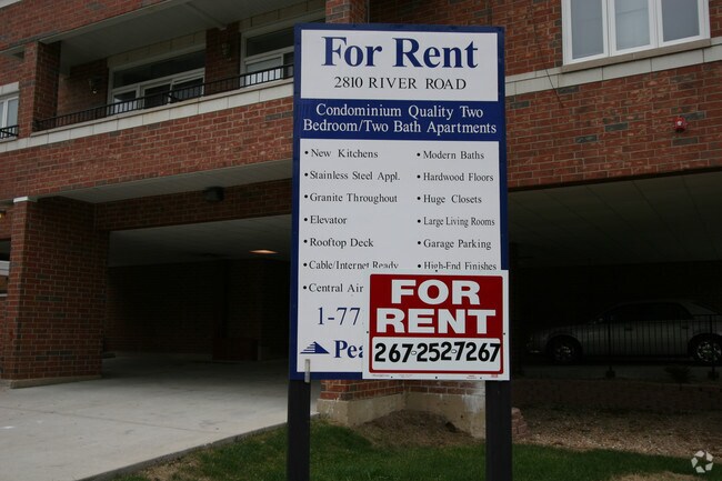

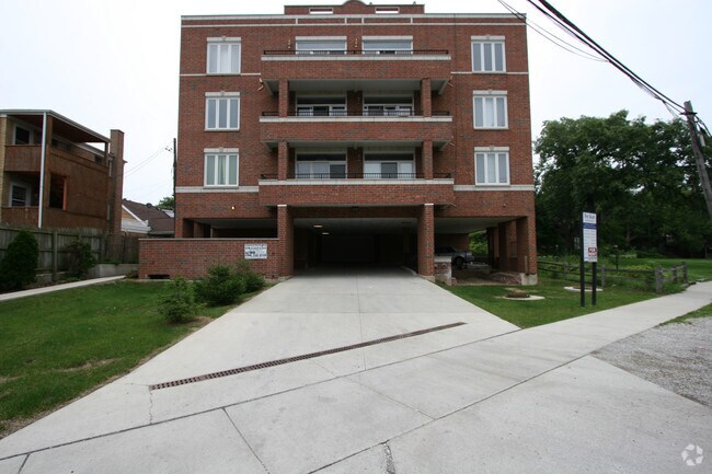

Property Detail
2810 River Rd
12-27-221-065-0000
Cook
Commercialnec
Illinois
AE The base floodplain where base flood elevations are provided. AE Zones are now used on new format FIRMs instead of A1-A30 Zones.
1
2023
0.27 AC
2025
River Grove
811200
Chicago
15,063 SF
Chicago-Naperville-Elgin, IL-IN
NEARBY LISTINGS FOR SALE OR LEASE
DEMOGRAPHICS near 2810 River Rd
1 mile
3 mile
5 mile
2025 Total Population
13,713
182,359
533,167
2030 Population
13,827
181,553
528,004
Pop Growth 2025-2030
+ 0.83%
(0.44%)
(0.97%)
Average Age
42
41
41
2025 Total Households
5,394
64,530
195,042
HH Growth 2025-2030
+ 0.65%
(0.65%)
(1.03%)
Median Household Inc
$73,234
$80,791
$82,479
Avg Household Size
2.50
2.70
2.60
2025 Avg HH Vehicles
2.00
2.00
2.00
Median Home Value
$262,491
$308,037
$322,607
Median Year Built
1958
1956
1953
Nearby Places
Map Layers
Map Styles
 Street
 Aerial
Layers
 Traffic
 Biking
Places
Listings with unknown addresses are not visible on the map
- Restaurants
- Banks
- Shops
- Fitness
- Groceries
PUBLIC TRANSPORTATION
COMMUTER RAIL
River Grove Station (Milwaukee District West Line - Northeast Illinois Regional Commuter Railroad (Metra), North Central Service - Northeast Illinois Regional Commuter Railroad (Metra))
Drive
Walk
Distance
River Grove Station (Milwaukee District West Line - Northeast Illinois Regional Commuter Railroad (Metra), North Central Service - Northeast Illinois Regional Commuter Railroad (Metra))
2 min
13 min
0.7 mi
Franklin Park-Belmont Ave Station (Ncs) (North Central Service - Northeast Illinois Regional Commuter Railroad (Metra))
Drive
Walk
Distance
Franklin Park-Belmont Ave Station (Ncs) (North Central Service - Northeast Illinois Regional Commuter Railroad (Metra))
2 min
20 min
1.1 mi
AIRPORT
Chicago O'Hare International
Drive
Walk
Distance
Chicago O'Hare International
12 min
6.5 mi
Chicago Midway International
Drive
Walk
Distance
Chicago Midway International
26 min
14.9 mi
Freight Ports
Port Milwaukee
Drive
Walk
Distance
Port Milwaukee
96 min
79.6 mi
Nearby Properties
Address
Land Use
TOTAL SIZE
Lot Size
Zoning
Address
Land Use
TOTAL SIZE
Lot Size
Zoning
86.63 AC
Address
Land Use
TOTAL SIZE
Lot Size
Zoning
Address
Land Use
TOTAL SIZE
Lot Size
Zoning
595,800 SF
9.40 AC
Address
Land Use
TOTAL SIZE
Lot Size
Zoning
9.90 AC
Address
Land Use
TOTAL SIZE
Lot Size
Zoning
396,650 SF
19.12 AC
Address
Land Use
TOTAL SIZE
Lot Size
Zoning
Address
Land Use
TOTAL SIZE
Lot Size
Zoning
Address
Land Use
TOTAL SIZE
Lot Size
Zoning
668,072 SF
4.19 AC
Address
Land Use
TOTAL SIZE
Lot Size
Zoning
548,206 SF
21.13 AC
Address
Land Use
TOTAL SIZE
Lot Size
Zoning
790,000 SF
31.71 AC
Address
Land Use
TOTAL SIZE
Lot Size
Zoning
531,227 SF
18.32 AC
Address
Land Use
TOTAL SIZE
Lot Size
Zoning
276,458 SF
16.14 AC
Address
Land Use
TOTAL SIZE
Lot Size
Zoning
194,219 SF
17.26 AC
Address
Land Use
TOTAL SIZE
Lot Size
Zoning
187,293 SF
6.22 AC
Address
Land Use
TOTAL SIZE
Lot Size
Zoning
Address
Land Use
TOTAL SIZE
Lot Size
Zoning
51.12 AC
Address
Land Use
TOTAL SIZE
Lot Size
Zoning
13.33 AC
PD 127
Address
Land Use
TOTAL SIZE
Lot Size
Zoning
325,045 SF
13.79 AC
Address
Land Use
TOTAL SIZE
Lot Size
Zoning
95,614 SF
4.20 AC
Address
Land Use
TOTAL SIZE
Lot Size
Zoning
281,212 SF
18.85 AC
Address
Land Use
TOTAL SIZE
Lot Size
Zoning
343,538 SF
13.54 AC
Address
Land Use
TOTAL SIZE
Lot Size
Zoning
432,777 SF
22.29 AC
Address
Land Use
TOTAL SIZE
Lot Size
Zoning
479,130 SF
15.80 AC
Address
Land Use
TOTAL SIZE
Lot Size
Zoning
348,133 SF
2.69 AC
Address
Land Use
TOTAL SIZE
Lot Size
Zoning
13.60 AC
Address
Land Use
TOTAL SIZE
Lot Size
Zoning
Address
Land Use
TOTAL SIZE
Lot Size
Zoning
141,095 SF
9.15 AC
PD 127
Address
Land Use
TOTAL SIZE
Lot Size
Zoning
139,665 SF
11.63 AC
Address
Land Use
TOTAL SIZE
Lot Size
Zoning
Address
Land Use
TOTAL SIZE
Lot Size
Zoning
367,389 SF
17.64 AC
The World's #1 Commercial Real Estate Marketplace
Connect with us
© 2026 CoStar Group
The information above has been obtained from sources believed reliable. While we do not doubt its accuracy we have not verified it and make no guarantee, warranty or representation about it. It is your responsibility to independently confirm its accuracy and completeness. Any projections, opinions, assumptions, or estimates used are for example only and do not represent the current or future performance of the property. The value of this transaction to you depends on tax and other factors which should be evaluated by your tax, financial, and legal advisors. You and your advisors should conduct a careful, independent investigation of the property to determine to your satisfaction the suitability of the property for your needs.