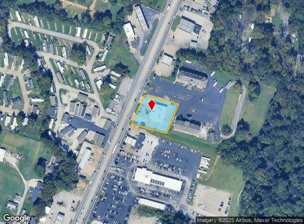
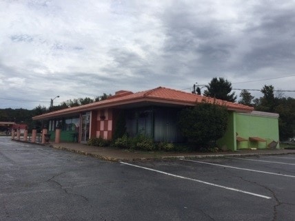
Property Record
2810 Us Highway 41 N, Henderson, KY 42420

NEARBY LISTINGS FOR SALE OR LEASE
Property Detail
2810 Us Highway 41 N
55F-96
RETAIL
Storebuilding
Henderson
X
Kentucky
21101C0089F
1 AC
2025
Henderson County
2025
Evansville
020701
Evansville, IN-KY
DEMOGRAPHICS near 2810 Us Highway 41 N
1 Mile
3 Mile
5 Mile
2024 Total Population
4,335
12,566
30,878
2029 Population
4,254
12,335
30,394
Pop Growth 2024-2029
(1.87%)
(1.84%)
(1.57%)
Average Age
41
43
41
2024 Total Households
1,864
5,705
13,074
HH Growth 2024-2029
(1.88%)
(1.84%)
(1.60%)
Median Household Inc
$52,342
$46,040
$47,355
Avg Household Size
2.20
2.10
2.20
2024 Avg HH Vehicles
2.00
2.00
2.00
Median Home Value
$141,637
$156,465
$143,034
Median Year Built
1981
1980
1974
Nearby Places
Map Layers
Map Styles
 Street
 Aerial
- Restaurants
- Banks
- Shops
- Fitness
- Groceries
PUBLIC TRANSPORTATION
AIRPORT
Evansville Regional
DRIVE
WALK
Distance
Evansville Regional
21 min
11.7 mi
Freight Ports
Port of Toledo
DRIVE
WALK
Distance
Port of Toledo
466 min
401.4 mi
SALE & LEASE HISTORY
LISTING DATE
SALE/LEASE

Jul 28, 2017
For Lease
Aug 10, 2017
For Sale
Apr 25, 2018
For Sale
Nearby Properties
Address
Land Use
TOTAL SIZE
Lot Size
Zoning
Address
Land Use
TOTAL SIZE
Lot Size
Zoning
524,000 SF
20.76 AC
Address
Land Use
TOTAL SIZE
Lot Size
Zoning
16.35 AC
Address
Land Use
TOTAL SIZE
Lot Size
Zoning
20.87 AC
Address
Land Use
TOTAL SIZE
Lot Size
Zoning
53,803 SF
4 AC
Address
Land Use
TOTAL SIZE
Lot Size
Zoning
25.17 AC
COMMERCIAL
Address
Land Use
TOTAL SIZE
Lot Size
Zoning
Address
Land Use
TOTAL SIZE
Lot Size
Zoning
126.50 AC
Address
Land Use
TOTAL SIZE
Lot Size
Zoning
3,306 SF
231.61 AC
Address
Land Use
TOTAL SIZE
Lot Size
Zoning
83,956 SF
8.85 AC
Address
Land Use
TOTAL SIZE
Lot Size
Zoning
13.71 AC
COMMERCIAL
Address
Land Use
TOTAL SIZE
Lot Size
Zoning
12,996 SF
1.97 AC
COMMERCIAL
Address
Land Use
TOTAL SIZE
Lot Size
Zoning
Address
Land Use
TOTAL SIZE
Lot Size
Zoning
89,082 SF
4.39 AC
Address
Land Use
TOTAL SIZE
Lot Size
Zoning
21,500 SF
1.25 AC
COMMERCIAL
Address
Land Use
TOTAL SIZE
Lot Size
Zoning
15,872 SF
12.11 AC
Address
Land Use
TOTAL SIZE
Lot Size
Zoning
1,872 SF
517.96 AC
Address
Land Use
TOTAL SIZE
Lot Size
Zoning
29,896 SF
1.32 AC
Address
Land Use
TOTAL SIZE
Lot Size
Zoning
1,473 SF
4 AC
Address
Land Use
TOTAL SIZE
Lot Size
Zoning
62,600 SF
5.65 AC
Address
Land Use
TOTAL SIZE
Lot Size
Zoning
11.79 AC
COMMERCIAL
Address
Land Use
TOTAL SIZE
Lot Size
Zoning
97,350 SF
4.76 AC
COMMERCIAL
Address
Land Use
TOTAL SIZE
Lot Size
Zoning
14,000 SF
1.49 AC
Address
Land Use
TOTAL SIZE
Lot Size
Zoning
1.55 AC
Address
Land Use
TOTAL SIZE
Lot Size
Zoning
1.37 AC
Address
Land Use
TOTAL SIZE
Lot Size
Zoning
Address
Land Use
TOTAL SIZE
Lot Size
Zoning
1.26 AC
COMMERCIAL
Address
Land Use
TOTAL SIZE
Lot Size
Zoning
34,452 SF
11.86 AC
Address
Land Use
TOTAL SIZE
Lot Size
Zoning
1,652 SF
6.84 AC
COMMERCIAL
Address
Land Use
TOTAL SIZE
Lot Size
Zoning
2,240 SF
0.86 AC
Address
Land Use
TOTAL SIZE
Lot Size
Zoning
21,136 SF
4.10 AC
The World's #1 Commercial Real Estate Marketplace
Connect with us
© 2026 CoStar Group
The information above has been obtained from sources believed reliable. While we do not doubt its accuracy we have not verified it and make no guarantee, warranty or representation about it. It is your responsibility to independently confirm its accuracy and completeness. Any projections, opinions, assumptions, or estimates used are for example only and do not represent the current or future performance of the property. The value of this transaction to you depends on tax and other factors which should be evaluated by your tax, financial, and legal advisors. You and your advisors should conduct a careful, independent investigation of the property to determine to your satisfaction the suitability of the property for your needs.