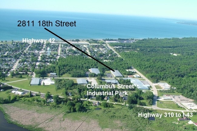
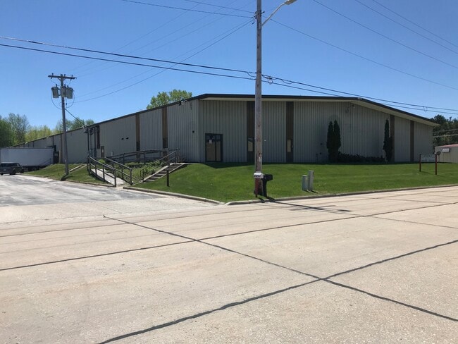
Property Record
2811 18Th St, Two Rivers, WI 54241

Property Detail
2811 18Th St
053-202-103-030.02
SW 1/4 NE 1/4 S2 T19N R24E TRACT 3 OF CSM V 10 P 3
Commercialnec
Manitowoc
I2
Wisconsin
B and X Area of moderate flood hazard, usually the area between the limits of the 100-year and 500-year floods.
3.87 AC
2024
Wisconsin South Area
2024
Other Market Areas
005400
Manitowoc, WI
93,600 SF
NEARBY LISTINGS FOR SALE OR LEASE
DEMOGRAPHICS near 2811 18Th St
1 mile
3 mile
5 mile
2025 Total Population
4,321
13,141
23,468
2030 Population
4,320
13,198
23,521
Pop Growth 2025-2030
(0.02%)
+ 0.43%
+ 0.23%
Average Age
43
45
45
2025 Total Households
1,946
5,997
10,746
HH Growth 2025-2030
(0.05%)
+ 0.45%
+ 0.22%
Median Household Inc
$51,081
$59,814
$60,484
Avg Household Size
2.20
2.10
2.10
2025 Avg HH Vehicles
2.00
2.00
2.00
Median Home Value
$131,737
$161,702
$170,996
Median Year Built
1950
1959
1959
Nearby Places
Map Layers
Map Styles
 Street
 Aerial
Transit
 Traffic
 Biking
Places
Listings with unknown addresses are not visible on the map
- Restaurants
- Banks
- Shops
- Fitness
- Groceries
PUBLIC TRANSPORTATION
AIRPORT
Green Bay/Austin Straubel International
Drive
Walk
Distance
Green Bay/Austin Straubel International
55 min
42.6 mi
SALE & LEASE HISTORY
LISTING DATE
SALE/LEASE

Sep 25, 2016
For Lease
Jun 14, 2022
For Lease
Dec 15, 2022
For Sale
Nearby Properties
Address
Land Use
TOTAL SIZE
Lot Size
Zoning
Address
Land Use
TOTAL SIZE
Lot Size
Zoning
97,963 SF
12.33 AC
B3
Address
Land Use
TOTAL SIZE
Lot Size
Zoning
105,564 SF
13.27 AC
Address
Land Use
TOTAL SIZE
Lot Size
Zoning
39.74 AC
I3
Address
Land Use
TOTAL SIZE
Lot Size
Zoning
30,576 SF
11.25 AC
Address
Land Use
TOTAL SIZE
Lot Size
Zoning
69,436 SF
18 AC
Address
Land Use
TOTAL SIZE
Lot Size
Zoning
30.22 AC
I2
Address
Land Use
TOTAL SIZE
Lot Size
Zoning
11.60 AC
Address
Land Use
TOTAL SIZE
Lot Size
Zoning
157,392 SF
7.54 AC
PUD
Address
Land Use
TOTAL SIZE
Lot Size
Zoning
71.56 AC
Address
Land Use
TOTAL SIZE
Lot Size
Zoning
33,012 SF
1.11 AC
B1
Address
Land Use
TOTAL SIZE
Lot Size
Zoning
164,517 SF
10.71 AC
IPF
Address
Land Use
TOTAL SIZE
Lot Size
Zoning
638,600 SF
20.47 AC
I2
Address
Land Use
TOTAL SIZE
Lot Size
Zoning
83,486 SF
3.82 AC
B2
Address
Land Use
TOTAL SIZE
Lot Size
Zoning
20,696 SF
2.27 AC
B1
Address
Land Use
TOTAL SIZE
Lot Size
Zoning
52,033 SF
2.19 AC
R4
Address
Land Use
TOTAL SIZE
Lot Size
Zoning
45,048 SF
1.35 AC
B1
Address
Land Use
TOTAL SIZE
Lot Size
Zoning
37,703 SF
1.76 AC
R4
Address
Land Use
TOTAL SIZE
Lot Size
Zoning
6.19 AC
I2
Address
Land Use
TOTAL SIZE
Lot Size
Zoning
3,700 SF
5.06 AC
R3
Address
Land Use
TOTAL SIZE
Lot Size
Zoning
90,778 SF
3.51 AC
B1
Address
Land Use
TOTAL SIZE
Lot Size
Zoning
45,360 SF
1.75 AC
PUD
Address
Land Use
TOTAL SIZE
Lot Size
Zoning
34,578 SF
0.62 AC
PUD
Address
Land Use
TOTAL SIZE
Lot Size
Zoning
46,080 SF
2.01 AC
PUD
Address
Land Use
TOTAL SIZE
Lot Size
Zoning
9,776 SF
1.14 AC
OSB
Address
Land Use
TOTAL SIZE
Lot Size
Zoning
84,696 SF
11.69 AC
Address
Land Use
TOTAL SIZE
Lot Size
Zoning
5.39 AC
I1
Address
Land Use
TOTAL SIZE
Lot Size
Zoning
29,268 SF
1.36 AC
R3
Address
Land Use
TOTAL SIZE
Lot Size
Zoning
46,800 SF
2.06 AC
I2
Address
Land Use
TOTAL SIZE
Lot Size
Zoning
41,256 SF
0.94 AC
R4
Address
Land Use
TOTAL SIZE
Lot Size
Zoning
12.25 AC
I2
The World's #1 Commercial Real Estate Marketplace
Connect with us
© 2026 CoStar Group
The information above has been obtained from sources believed reliable. While we do not doubt its accuracy we have not verified it and make no guarantee, warranty or representation about it. It is your responsibility to independently confirm its accuracy and completeness. Any projections, opinions, assumptions, or estimates used are for example only and do not represent the current or future performance of the property. The value of this transaction to you depends on tax and other factors which should be evaluated by your tax, financial, and legal advisors. You and your advisors should conduct a careful, independent investigation of the property to determine to your satisfaction the suitability of the property for your needs.