Property Record
2811 London Groveport Rd, Grove City, OH 43123


NEARBY LISTINGS FOR SALE OR LEASE
-
-
View all Grove City listings for sale on LoopNet.com
Property Detail
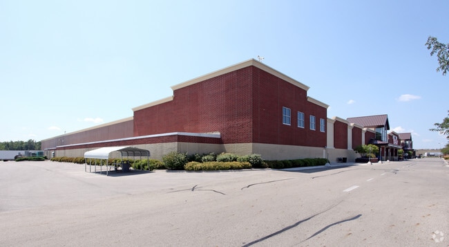
2811 London Groveport Rd
Columbus, OH
Vms 6115 (Destroyed By Fire)
040-008045
2811 LONDON-GROVEPORT RD O Q 3900 ENTRY 6115 15.342 ACRES
Agriculturalland
Franklin
2024
Ohio
2024
15.34 AC
009751
Southwest
210,930 SF
Columbus
DEMOGRAPHICS near 2811 London Groveport Rd
1 Mile
3 Mile
5 Mile
2024 Total Population
1,736
26,587
61,699
2029 Population
1,744
26,808
62,495
Pop Growth 2024-2029
+ 0.46%
+ 0.83%
+ 1.29%
Average Age
48
41
40
2024 Total Households
848
10,188
23,705
HH Growth 2024-2029
+ 0.47%
+ 0.80%
+ 1.20%
Median Household Inc
$72,742
$105,087
$85,278
Avg Household Size
2.00
2.50
2.50
2024 Avg HH Vehicles
2.00
2.00
2.00
Median Home Value
$258,745
$277,074
$254,076
Median Year Built
2003
1997
1993
Nearby Places
Map Layers
Map Styles
 Street
 Aerial
- Restaurants
- Banks
- Shops
- Fitness
- Groceries
PUBLIC TRANSPORTATION
AIRPORT
Rickenbacker International
DRIVE
WALK
Distance
Rickenbacker International
19 min
10.0 mi
John Glenn Columbus International
DRIVE
WALK
Distance
John Glenn Columbus International
26 min
18.4 mi
Nearby Properties
Address
Land Use
TOTAL SIZE
Lot Size
Zoning
Address
Land Use
TOTAL SIZE
Lot Size
Zoning
844,679 SF
61.71 AC
Address
Land Use
TOTAL SIZE
Lot Size
Zoning
227,844 SF
21.57 AC
Address
Land Use
TOTAL SIZE
Lot Size
Zoning
46,692 SF
22.40 AC
Address
Land Use
TOTAL SIZE
Lot Size
Zoning
227,576 SF
52.33 AC
Address
Land Use
TOTAL SIZE
Lot Size
Zoning
60,893 SF
19.92 AC
Address
Land Use
TOTAL SIZE
Lot Size
Zoning
227,826 SF
15.68 AC
Address
Land Use
TOTAL SIZE
Lot Size
Zoning
81,687 SF
10.19 AC
Address
Land Use
TOTAL SIZE
Lot Size
Zoning
110,447 SF
28.14 AC
Address
Land Use
TOTAL SIZE
Lot Size
Zoning
111,076 SF
15.98 AC
Address
Land Use
TOTAL SIZE
Lot Size
Zoning
82,538 SF
16.16 AC
Address
Land Use
TOTAL SIZE
Lot Size
Zoning
274,295 SF
37.25 AC
Address
Land Use
TOTAL SIZE
Lot Size
Zoning
102,950 SF
12.70 AC
Address
Land Use
TOTAL SIZE
Lot Size
Zoning
371,370 SF
26.31 AC
Address
Land Use
TOTAL SIZE
Lot Size
Zoning
132,107 SF
84.68 AC
Address
Land Use
TOTAL SIZE
Lot Size
Zoning
25,820 SF
22.25 AC
Address
Land Use
TOTAL SIZE
Lot Size
Zoning
208,320 SF
21.11 AC
Address
Land Use
TOTAL SIZE
Lot Size
Zoning
269,360 SF
15.06 AC
Address
Land Use
TOTAL SIZE
Lot Size
Zoning
192,600 SF
16.43 AC
Address
Land Use
TOTAL SIZE
Lot Size
Zoning
210,930 SF
28.12 AC
Address
Land Use
TOTAL SIZE
Lot Size
Zoning
123,352 SF
16.74 AC
Address
Land Use
TOTAL SIZE
Lot Size
Zoning
117,126 SF
5.51 AC
Address
Land Use
TOTAL SIZE
Lot Size
Zoning
104,647 SF
4.40 AC
Address
Land Use
TOTAL SIZE
Lot Size
Zoning
50,508 SF
3.43 AC
Address
Land Use
TOTAL SIZE
Lot Size
Zoning
98,323 SF
9.23 AC
Address
Land Use
TOTAL SIZE
Lot Size
Zoning
68,625 SF
19.11 AC
Address
Land Use
TOTAL SIZE
Lot Size
Zoning
52,456 SF
1.87 AC
Address
Land Use
TOTAL SIZE
Lot Size
Zoning
42,320 SF
94.62 AC
Address
Land Use
TOTAL SIZE
Lot Size
Zoning
66,740 SF
6.72 AC
Address
Land Use
TOTAL SIZE
Lot Size
Zoning
38,410 SF
4.30 AC
Address
Land Use
TOTAL SIZE
Lot Size
Zoning
31,455 SF
42.31 AC
The World's #1 Commercial Real Estate Marketplace
Connect with us
© 2025 CoStar Group
The information above has been obtained from sources believed reliable. While we do not doubt its accuracy we have not verified it and make no guarantee, warranty or representation about it. It is your responsibility to independently confirm its accuracy and completeness. Any projections, opinions, assumptions, or estimates used are for example only and do not represent the current or future performance of the property. The value of this transaction to you depends on tax and other factors which should be evaluated by your tax, financial, and legal advisors. You and your advisors should conduct a careful, independent investigation of the property to determine to your satisfaction the suitability of the property for your needs.