Property Record
28111 Vallie St, Pinehurst, TX 77362
Save to a Folder
{{folder.Name}}
{{folder.ListingIds.length}} Properties
{{folder.ListingIds.length}} Property
Create a New Folder
This Property Is For Sale
Property Detail
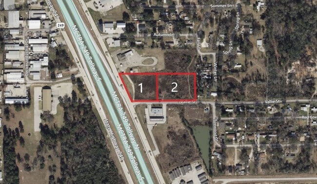
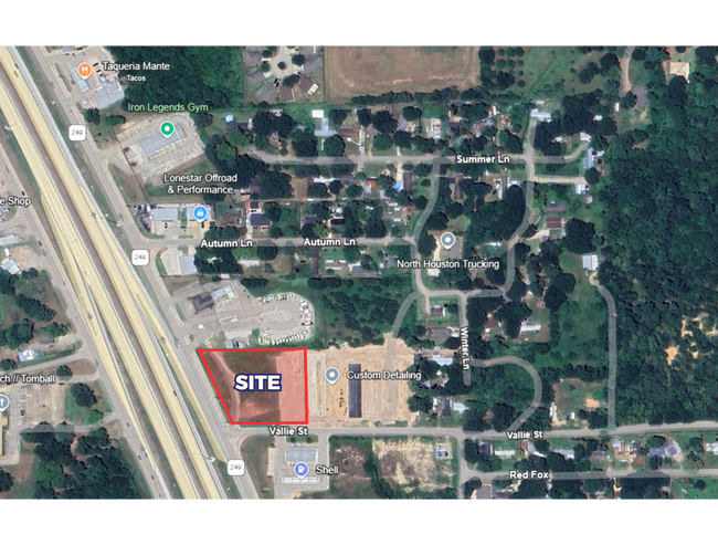
28111 Vallie St
0264-00-07810
A0264 HALE E R, TRACT 78-B, ACRES 1.240
Commercialnec
MONTGOMERY
2
Texas
C and X Area of minimal flood hazard, usually depicted on FIRMs as above the 500-year flood level.
0.33 AC
2024
Northwest Outlier
2025
Houston
690405
Houston-Pasadena-The Woodlands, TX
572 SF
NEARBY LISTINGS FOR SALE OR LEASE
DEMOGRAPHICS near 28111 Vallie St
1 mile
3 mile
5 mile
2025 Total Population
3,680
23,939
60,988
2030 Population
4,297
27,331
69,714
Pop Growth 2025-2030
+ 16.77%
+ 14.17%
+ 14.31%
Average Age
36
40
39
2025 Total Households
1,237
8,515
21,458
HH Growth 2025-2030
+ 17.30%
+ 14.22%
+ 14.39%
Median Household Inc
$82,766
$100,521
$97,775
Avg Household Size
2.90
2.80
2.80
2025 Avg HH Vehicles
2.00
2.00
2.00
Median Home Value
$286,196
$396,681
$399,412
Median Year Built
2007
2001
2006
Nearby Places
Map Layers
Map Styles
 Street
 Aerial
Layers
 Traffic
 Biking
Places
Listings with unknown addresses are not visible on the map
- Restaurants
- Banks
- Shops
- Fitness
- Groceries
PUBLIC TRANSPORTATION
AIRPORT
George Bush Intcntl/Houston
Drive
Walk
Distance
George Bush Intcntl/Houston
39 min
31.0 mi
William P Hobby
Drive
Walk
Distance
William P Hobby
67 min
46.1 mi
Freight Ports
Port of Houston
Drive
Walk
Distance
Port of Houston
59 min
41.7 mi
Nearby Properties
Address
Land Use
TOTAL SIZE
Lot Size
Zoning
Address
Land Use
TOTAL SIZE
Lot Size
Zoning
148,105 SF
19.73 AC
Address
Land Use
TOTAL SIZE
Lot Size
Zoning
179,083 SF
8.29 AC
Address
Land Use
TOTAL SIZE
Lot Size
Zoning
110,553 SF
10.34 AC
Address
Land Use
TOTAL SIZE
Lot Size
Zoning
176,180 SF
7.28 AC
Address
Land Use
TOTAL SIZE
Lot Size
Zoning
146,990 SF
7.02 AC
Address
Land Use
TOTAL SIZE
Lot Size
Zoning
59,119 SF
6.26 AC
Address
Land Use
TOTAL SIZE
Lot Size
Zoning
112,854 SF
5.80 AC
Address
Land Use
TOTAL SIZE
Lot Size
Zoning
118,004 SF
5.55 AC
Address
Land Use
TOTAL SIZE
Lot Size
Zoning
135,804 SF
15.33 AC
Address
Land Use
TOTAL SIZE
Lot Size
Zoning
65,475 SF
7.84 AC
Address
Land Use
TOTAL SIZE
Lot Size
Zoning
104,859 SF
5.29 AC
Address
Land Use
TOTAL SIZE
Lot Size
Zoning
73,992 SF
7.21 AC
Address
Land Use
TOTAL SIZE
Lot Size
Zoning
122,970 SF
11.79 AC
Address
Land Use
TOTAL SIZE
Lot Size
Zoning
81,277 SF
4.43 AC
Address
Land Use
TOTAL SIZE
Lot Size
Zoning
41,541 SF
3.93 AC
Address
Land Use
TOTAL SIZE
Lot Size
Zoning
24,483 SF
9.66 AC
Address
Land Use
TOTAL SIZE
Lot Size
Zoning
14,865 SF
1.98 AC
2
Address
Land Use
TOTAL SIZE
Lot Size
Zoning
64,986 SF
4.75 AC
Address
Land Use
TOTAL SIZE
Lot Size
Zoning
90,311 SF
10 AC
Address
Land Use
TOTAL SIZE
Lot Size
Zoning
7,800 SF
18.47 AC
Address
Land Use
TOTAL SIZE
Lot Size
Zoning
100,389 SF
5.47 AC
2
Address
Land Use
TOTAL SIZE
Lot Size
Zoning
1,184 SF
27.54 AC
Address
Land Use
TOTAL SIZE
Lot Size
Zoning
48,896 SF
2 AC
Address
Land Use
TOTAL SIZE
Lot Size
Zoning
10,946 SF
0.91 AC
Address
Land Use
TOTAL SIZE
Lot Size
Zoning
28,189 SF
2.07 AC
Address
Land Use
TOTAL SIZE
Lot Size
Zoning
12,798 SF
1.18 AC
Address
Land Use
TOTAL SIZE
Lot Size
Zoning
67,125 SF
10.41 AC
Address
Land Use
TOTAL SIZE
Lot Size
Zoning
1,722 SF
31.19 AC
2
Address
Land Use
TOTAL SIZE
Lot Size
Zoning
25,050 SF
2.16 AC
Address
Land Use
TOTAL SIZE
Lot Size
Zoning
12,276 SF
4.81 AC
The World's #1 Commercial Real Estate Marketplace
Connect with us
© 2026 CoStar Group
The information above has been obtained from sources believed reliable. While we do not doubt its accuracy we have not verified it and make no guarantee, warranty or representation about it. It is your responsibility to independently confirm its accuracy and completeness. Any projections, opinions, assumptions, or estimates used are for example only and do not represent the current or future performance of the property. The value of this transaction to you depends on tax and other factors which should be evaluated by your tax, financial, and legal advisors. You and your advisors should conduct a careful, independent investigation of the property to determine to your satisfaction the suitability of the property for your needs.