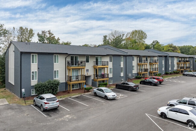
Property Record
2814 De Mel Ave, Louisville, KY 40214

NEARBY LISTINGS FOR SALE OR LEASE
Property Detail
2814 De Mel Ave
102101100000
Minor Sub 1
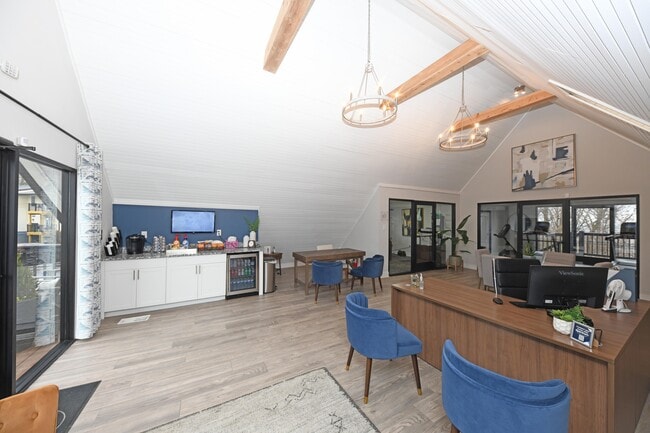
Apartment
13.67 AC+- TRACT 1 MINOR PLAT DB 7214 PG 484 WM SANDERS SHIVELY SKI LODGE APTS OFF GAGEL AVE THE SUMMIT APTS
X
Jefferson
21111C0073F
Kentucky
2025
13.67 AC
2025
South Louisville
012302
Louisville
15,928 SF
Louisville-Jefferson County, KY-IN
DEMOGRAPHICS near 2814 De Mel Ave
1 Mile
3 Mile
5 Mile
2024 Total Population
9,815
102,574
199,283
2029 Population
9,732
101,592
197,308
Pop Growth 2024-2029
(0.85%)
(0.96%)
(0.99%)
Average Age
40
39
38
2024 Total Households
3,929
41,519
80,642
HH Growth 2024-2029
(0.87%)
(1.01%)
(1.05%)
Median Household Inc
$54,930
$46,076
$45,629
Avg Household Size
2.40
2.40
2.30
2024 Avg HH Vehicles
2.00
2.00
2.00
Median Home Value
$165,659
$155,618
$153,245
Median Year Built
1965
1960
1960
Nearby Places
Map Layers
Map Styles
 Street
 Aerial
- Restaurants
- Banks
- Shops
- Fitness
- Groceries
PUBLIC TRANSPORTATION
AIRPORT
Louisville Muhammad Ali International
DRIVE
WALK
Distance
Louisville Muhammad Ali International
14 min
4.5 mi
Freight Ports
Port of Toledo
DRIVE
WALK
Distance
Port of Toledo
366 min
312.2 mi
Nearby Properties
Address
Land Use
TOTAL SIZE
Lot Size
Zoning
Address
Land Use
TOTAL SIZE
Lot Size
Zoning
22,113 SF
19.01 AC
R4-RESIDEN
Address
Land Use
TOTAL SIZE
Lot Size
Zoning
16.31 AC
OR1-OFFICE
Address
Land Use
TOTAL SIZE
Lot Size
Zoning
256,872 SF
23.71 AC
C1-COMMERC
Address
Land Use
TOTAL SIZE
Lot Size
Zoning
5,560 SF
Address
Land Use
TOTAL SIZE
Lot Size
Zoning
17,270 SF
4.74 AC
R5-RESIDEN
Address
Land Use
TOTAL SIZE
Lot Size
Zoning
5,568 SF
13.52 AC
C1-COMMERC
Address
Land Use
TOTAL SIZE
Lot Size
Zoning
285,378 SF
16.79 AC
EZ1-ENTERP
Address
Land Use
TOTAL SIZE
Lot Size
Zoning
308 SF
57.16 AC
EZ1-ENTERP
Address
Land Use
TOTAL SIZE
Lot Size
Zoning
164,677 SF
13.54 AC
EZ1-ENTERP
Address
Land Use
TOTAL SIZE
Lot Size
Zoning
29.54 AC
R5-RESIDEN
Address
Land Use
TOTAL SIZE
Lot Size
Zoning
19,032 SF
5.88 AC
C1-COMMERC
Address
Land Use
TOTAL SIZE
Lot Size
Zoning
13,600 SF
14.89 AC
R7-RESIDEN
Address
Land Use
TOTAL SIZE
Lot Size
Zoning
4,250 SF
2.83 AC
OR1-OFFICE
Address
Land Use
TOTAL SIZE
Lot Size
Zoning
142,900 SF
19.05 AC
EZ1-ENTERP
Address
Land Use
TOTAL SIZE
Lot Size
Zoning
11,136 SF
11.02 AC
R4-RESIDEN
Address
Land Use
TOTAL SIZE
Lot Size
Zoning
136,798 SF
6.31 AC
EZ1-ENTERP
Address
Land Use
TOTAL SIZE
Lot Size
Zoning
2,352 SF
2.42 AC
C2-COMMERC
Address
Land Use
TOTAL SIZE
Lot Size
Zoning
Address
Land Use
TOTAL SIZE
Lot Size
Zoning
24,896 SF
5.47 AC
C1-COMMERC
Address
Land Use
TOTAL SIZE
Lot Size
Zoning
19,375 SF
10.11 AC
C1-COMMERC
Address
Land Use
TOTAL SIZE
Lot Size
Zoning
121,509 SF
4.48 AC
Address
Land Use
TOTAL SIZE
Lot Size
Zoning
11.18 AC
Address
Land Use
TOTAL SIZE
Lot Size
Zoning
5,800 SF
9.20 AC
R7-RESIDEN
Address
Land Use
TOTAL SIZE
Lot Size
Zoning
3,600 SF
7.35 AC
R7-RESIDEN
Address
Land Use
TOTAL SIZE
Lot Size
Zoning
91,913 SF
2.46 AC
C2-COMMERC
Address
Land Use
TOTAL SIZE
Lot Size
Zoning
152,140 SF
8.44 AC
EZ1-ENTERP
Address
Land Use
TOTAL SIZE
Lot Size
Zoning
14,176 SF
14.04 AC
R6-RESIDEN
Address
Land Use
TOTAL SIZE
Lot Size
Zoning
49,817 SF
17.53 AC
M2-INDUSTR
Address
Land Use
TOTAL SIZE
Lot Size
Zoning
170,619 SF
6.35 AC
R7-RESIDEN
The World's #1 Commercial Real Estate Marketplace
Connect with us
© 2025 CoStar Group
The information above has been obtained from sources believed reliable. While we do not doubt its accuracy we have not verified it and make no guarantee, warranty or representation about it. It is your responsibility to independently confirm its accuracy and completeness. Any projections, opinions, assumptions, or estimates used are for example only and do not represent the current or future performance of the property. The value of this transaction to you depends on tax and other factors which should be evaluated by your tax, financial, and legal advisors. You and your advisors should conduct a careful, independent investigation of the property to determine to your satisfaction the suitability of the property for your needs.