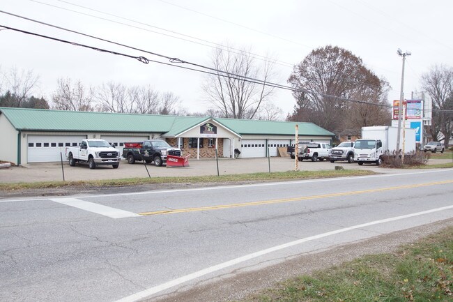
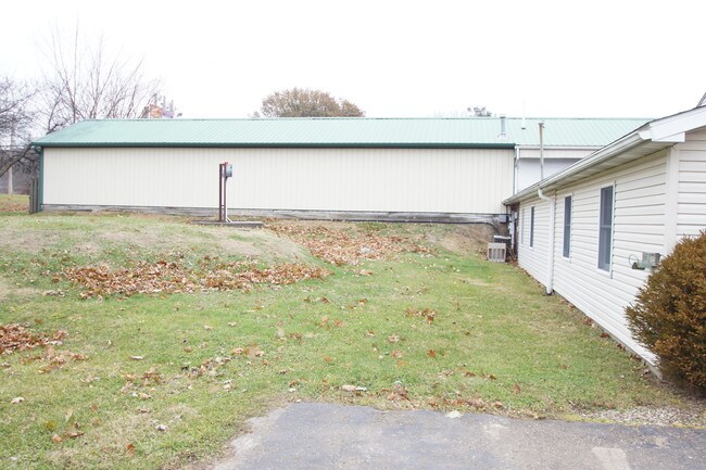
Property Record
2814 Edison St Nw, Uniontown, OH 44685

NEARBY LISTINGS FOR SALE OR LEASE
-
-
View all Uniontown listings for lease on LoopNet.com
Property Detail
2814 Edison St Nw
02202762
Daves Allotment
Officebuilding
8 NW 1.51A
X
Stark
39153C0285F
Ohio
0
1.51 AC
2025
Stark County
711112
Cleveland
6,250 SF
Canton-Massillon, OH
DEMOGRAPHICS near 2814 Edison St Nw
1 Mile
3 Mile
5 Mile
2024 Total Population
4,575
26,264
64,936
2029 Population
4,524
25,895
64,215
Pop Growth 2024-2029
(1.11%)
(1.40%)
(1.11%)
Average Age
41
42
42
2024 Total Households
1,679
10,227
26,142
HH Growth 2024-2029
(1.19%)
(1.44%)
(1.14%)
Median Household Inc
$81,933
$85,273
$76,426
Avg Household Size
2.70
2.50
2.40
2024 Avg HH Vehicles
2.00
2.00
2.00
Median Home Value
$197,383
$212,849
$201,052
Median Year Built
1975
1976
1976
Nearby Places
Map Layers
Map Styles
 Street
 Aerial
- Restaurants
- Banks
- Shops
- Fitness
- Groceries
PUBLIC TRANSPORTATION
AIRPORT
Akron-Canton Regional
DRIVE
WALK
Distance
Akron-Canton Regional
14 min
7.5 mi
Freight Ports
Port of Toledo
DRIVE
WALK
Distance
Port of Toledo
177 min
148.6 mi
SALE & LEASE HISTORY
LISTING DATE
SALE/LEASE

Nov 06, 2023
For Lease
Jul 28, 2020
For Lease
Jul 05, 2022
For Lease
Dec 04, 2019
For Sale
Nearby Properties
Address
Land Use
TOTAL SIZE
Lot Size
Zoning
Address
Land Use
TOTAL SIZE
Lot Size
Zoning
220,250 SF
15.78 AC
Address
Land Use
TOTAL SIZE
Lot Size
Zoning
Address
Land Use
TOTAL SIZE
Lot Size
Zoning
Address
Land Use
TOTAL SIZE
Lot Size
Zoning
146,057 SF
37.51 AC
Address
Land Use
TOTAL SIZE
Lot Size
Zoning
128,922 SF
17.84 AC
Address
Land Use
TOTAL SIZE
Lot Size
Zoning
286,697 SF
18.04 AC
Address
Land Use
TOTAL SIZE
Lot Size
Zoning
162,939 SF
14.22 AC
Address
Land Use
TOTAL SIZE
Lot Size
Zoning
127,106 SF
20.28 AC
Address
Land Use
TOTAL SIZE
Lot Size
Zoning
137,493 SF
11.61 AC
Address
Land Use
TOTAL SIZE
Lot Size
Zoning
68,325 SF
3.07 AC
Address
Land Use
TOTAL SIZE
Lot Size
Zoning
103,645 SF
29.83 AC
Address
Land Use
TOTAL SIZE
Lot Size
Zoning
46,002 SF
10.21 AC
Address
Land Use
TOTAL SIZE
Lot Size
Zoning
154,148 SF
15.85 AC
Address
Land Use
TOTAL SIZE
Lot Size
Zoning
23,797 SF
2.86 AC
Address
Land Use
TOTAL SIZE
Lot Size
Zoning
5.85 AC
Address
Land Use
TOTAL SIZE
Lot Size
Zoning
37,612 SF
7.65 AC
Address
Land Use
TOTAL SIZE
Lot Size
Zoning
10,417 SF
1.98 AC
Address
Land Use
TOTAL SIZE
Lot Size
Zoning
30,820 SF
5.59 AC
Address
Land Use
TOTAL SIZE
Lot Size
Zoning
30,389 SF
5.58 AC
Address
Land Use
TOTAL SIZE
Lot Size
Zoning
26,760 SF
11.16 AC
Address
Land Use
TOTAL SIZE
Lot Size
Zoning
77,366 SF
4.60 AC
Address
Land Use
TOTAL SIZE
Lot Size
Zoning
36,370 SF
9.09 AC
Address
Land Use
TOTAL SIZE
Lot Size
Zoning
Address
Land Use
TOTAL SIZE
Lot Size
Zoning
42,805 SF
26.69 AC
Address
Land Use
TOTAL SIZE
Lot Size
Zoning
30,044 SF
3.77 AC
Address
Land Use
TOTAL SIZE
Lot Size
Zoning
22,836 SF
4.15 AC
Address
Land Use
TOTAL SIZE
Lot Size
Zoning
24,749 SF
6.21 AC
Address
Land Use
TOTAL SIZE
Lot Size
Zoning
64,060 SF
7.96 AC
Address
Land Use
TOTAL SIZE
Lot Size
Zoning
2,446 SF
170.40 AC
Address
Land Use
TOTAL SIZE
Lot Size
Zoning
57,620 SF
2.62 AC
The World's #1 Commercial Real Estate Marketplace
Connect with us
© 2025 CoStar Group
The information above has been obtained from sources believed reliable. While we do not doubt its accuracy we have not verified it and make no guarantee, warranty or representation about it. It is your responsibility to independently confirm its accuracy and completeness. Any projections, opinions, assumptions, or estimates used are for example only and do not represent the current or future performance of the property. The value of this transaction to you depends on tax and other factors which should be evaluated by your tax, financial, and legal advisors. You and your advisors should conduct a careful, independent investigation of the property to determine to your satisfaction the suitability of the property for your needs.