Property Record
2815 Buford Dr, Buford, GA 30519
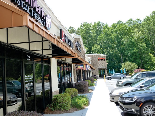

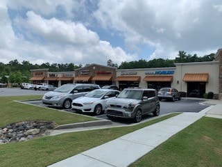
Property Detail
2815 Buford Dr
7-146-040
TRACT 3 GA HIGHWAY 20
Stripcommercialcenter
GWINNETT
C2
Georgia
B and X Area of moderate flood hazard, usually the area between the limits of the 100-year and 500-year floods.
2
2025
1.87 AC
2025
Suwanee/Buford
050611
Atlanta
18,589 SF
Atlanta-Sandy Springs-Roswell, GA
NEARBY LISTINGS FOR SALE OR LEASE
DEMOGRAPHICS near 2815 Buford Dr
1 mile
3 mile
5 mile
2024 Total Population
11,463
59,882
172,440
2029 Population
12,256
62,991
181,361
Pop Growth 2024-2029
+ 6.92%
+ 5.19%
+ 5.17%
Average Age
37
38
38
2024 Total Households
4,578
20,187
56,163
HH Growth 2024-2029
+ 7.14%
+ 5.45%
+ 5.38%
Median Household Inc
$80,110
$96,677
$99,327
Avg Household Size
2.50
2.90
3.00
2024 Avg HH Vehicles
2.00
2.00
2.00
Median Home Value
$375,329
$421,483
$427,149
Median Year Built
2005
2001
1999
Nearby Places
Map Layers
Map Styles
 Street
 Aerial
Transit
 Traffic
 Biking
Places
Listings with unknown addresses are not visible on the map
- Restaurants
- Banks
- Shops
- Fitness
- Groceries
PUBLIC TRANSPORTATION
AIRPORT
Hartsfield - Jackson Atlanta International
Drive
Walk
Distance
Hartsfield - Jackson Atlanta International
57 min
44.4 mi
SALE & LEASE HISTORY
LISTING DATE
SALE/LEASE

Oct 10, 2018
For Lease
Oct 10, 2018
For Sale
May 18, 2017
For Lease
Jul 11, 2019
For Lease
Feb 13, 2019
For Sale
Nearby Properties
Address
Land Use
TOTAL SIZE
Lot Size
Zoning
Address
Land Use
TOTAL SIZE
Lot Size
Zoning
1,435,842 SF
83.47 AC
C2
Address
Land Use
TOTAL SIZE
Lot Size
Zoning
563,718 SF
41.75 AC
RM13
Address
Land Use
TOTAL SIZE
Lot Size
Zoning
419,467 SF
665.75 AC
RZT
Address
Land Use
TOTAL SIZE
Lot Size
Zoning
455,605 SF
33.93 AC
RM13
Address
Land Use
TOTAL SIZE
Lot Size
Zoning
415,963 SF
48.86 AC
RM10
Address
Land Use
TOTAL SIZE
Lot Size
Zoning
461,593 SF
14.11 AC
MUR
Address
Land Use
TOTAL SIZE
Lot Size
Zoning
1,113,809 SF
57.50 AC
M1
Address
Land Use
TOTAL SIZE
Lot Size
Zoning
403,129 SF
126.91 AC
RA200
Address
Land Use
TOTAL SIZE
Lot Size
Zoning
330,562 SF
29.62 AC
RM13
Address
Land Use
TOTAL SIZE
Lot Size
Zoning
394,831 SF
16.37 AC
RM24
Address
Land Use
TOTAL SIZE
Lot Size
Zoning
684,003 SF
60.84 AC
M1
Address
Land Use
TOTAL SIZE
Lot Size
Zoning
415,609 SF
16.50 AC
RM24
Address
Land Use
TOTAL SIZE
Lot Size
Zoning
379,178 SF
39.27 AC
RM10
Address
Land Use
TOTAL SIZE
Lot Size
Zoning
367,419 SF
17.06 AC
RM24
Address
Land Use
TOTAL SIZE
Lot Size
Zoning
619,498 SF
51.81 AC
M1
Address
Land Use
TOTAL SIZE
Lot Size
Zoning
335,641 SF
28.90 AC
RM10
Address
Land Use
TOTAL SIZE
Lot Size
Zoning
439,723 SF
64.56 AC
R100
Address
Land Use
TOTAL SIZE
Lot Size
Zoning
282,431 SF
23.20 AC
RM13
Address
Land Use
TOTAL SIZE
Lot Size
Zoning
282,630 SF
11.83 AC
MUO
Address
Land Use
TOTAL SIZE
Lot Size
Zoning
514,956 SF
47.21 AC
M1
Address
Land Use
TOTAL SIZE
Lot Size
Zoning
335,438 SF
10.94 AC
MUR
Address
Land Use
TOTAL SIZE
Lot Size
Zoning
121,100 SF
3.74 AC
RM24
Address
Land Use
TOTAL SIZE
Lot Size
Zoning
192,805 SF
12.40 AC
RM24
Address
Land Use
TOTAL SIZE
Lot Size
Zoning
323,877 SF
29.14 AC
C2
Address
Land Use
TOTAL SIZE
Lot Size
Zoning
102,152 SF
20.95 AC
C2
Address
Land Use
TOTAL SIZE
Lot Size
Zoning
218,583 SF
2.21 AC
MUO
Address
Land Use
TOTAL SIZE
Lot Size
Zoning
223,096 SF
6.06 AC
MUR
Address
Land Use
TOTAL SIZE
Lot Size
Zoning
496,608 SF
29.68 AC
C2
Address
Land Use
TOTAL SIZE
Lot Size
Zoning
661,663 SF
50.64 AC
M1
Address
Land Use
TOTAL SIZE
Lot Size
Zoning
353,241 SF
33.16 AC
C2
The World's #1 Commercial Real Estate Marketplace
Connect with us
© 2026 CoStar Group
The information above has been obtained from sources believed reliable. While we do not doubt its accuracy we have not verified it and make no guarantee, warranty or representation about it. It is your responsibility to independently confirm its accuracy and completeness. Any projections, opinions, assumptions, or estimates used are for example only and do not represent the current or future performance of the property. The value of this transaction to you depends on tax and other factors which should be evaluated by your tax, financial, and legal advisors. You and your advisors should conduct a careful, independent investigation of the property to determine to your satisfaction the suitability of the property for your needs.